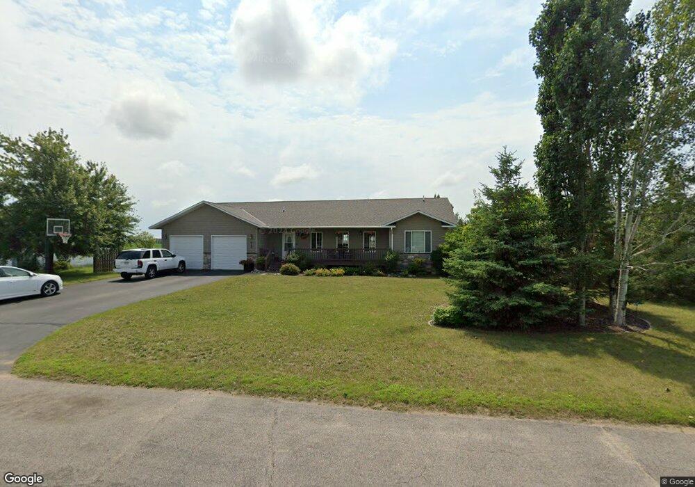
604 10th St W Park Rapids, MN 56470
Estimated Value: $365,875 - $571,000
5
Beds
3
Baths
1,805
Sq Ft
$235/Sq Ft
Est. Value
About This Home
This home is located at 604 10th St W, Park Rapids, MN 56470 and is currently estimated at $423,719, approximately $234 per square foot. 604 10th St W is a home located in Hubbard County with nearby schools including Century Elementary School, Century School, and Park Rapids Area High School.
Ownership History
Date
Name
Owned For
Owner Type
Purchase Details
Closed on
Apr 20, 2016
Sold by
Norby Stephen C and Norby Brenda J
Bought by
Perry Danielle
Current Estimated Value
Home Financials for this Owner
Home Financials are based on the most recent Mortgage that was taken out on this home.
Original Mortgage
$203,000
Outstanding Balance
$160,555
Interest Rate
3.71%
Mortgage Type
VA
Estimated Equity
$263,164
Purchase Details
Closed on
Feb 4, 2010
Sold by
Pearce James A and Pearce Christine L
Bought by
Norby Stephen C and Norby Brenda J
Home Financials for this Owner
Home Financials are based on the most recent Mortgage that was taken out on this home.
Original Mortgage
$135,000
Interest Rate
5.11%
Mortgage Type
New Conventional
Purchase Details
Closed on
Aug 6, 2007
Sold by
Smith Raymond W and Smith Darla A
Bought by
Pearce James A and Pearce Christine L
Create a Home Valuation Report for This Property
The Home Valuation Report is an in-depth analysis detailing your home's value as well as a comparison with similar homes in the area
Home Values in the Area
Average Home Value in this Area
Purchase History
| Date | Buyer | Sale Price | Title Company |
|---|---|---|---|
| Perry Danielle | $203,000 | None Available | |
| Norby Stephen C | $189,900 | None Available | |
| Pearce James A | $18,500 | None Available |
Source: Public Records
Mortgage History
| Date | Status | Borrower | Loan Amount |
|---|---|---|---|
| Open | Perry Danielle | $203,000 | |
| Previous Owner | Norby Stephen C | $135,000 |
Source: Public Records
Tax History
| Year | Tax Paid | Tax Assessment Tax Assessment Total Assessment is a certain percentage of the fair market value that is determined by local assessors to be the total taxable value of land and additions on the property. | Land | Improvement |
|---|---|---|---|---|
| 2024 | $4,498 | $360,500 | $18,400 | $342,100 |
| 2023 | $4,172 | $327,400 | $18,400 | $309,000 |
| 2022 | $3,552 | $307,300 | $18,400 | $288,900 |
| 2021 | $3,484 | $250,900 | $16,600 | $234,300 |
| 2020 | $3,300 | $233,100 | $17,389 | $215,711 |
| 2019 | $2,962 | $212,300 | $17,158 | $195,142 |
| 2018 | $2,812 | $180,700 | $14,554 | $166,146 |
| 2016 | $2,876 | $168,300 | $14,367 | $153,933 |
| 2015 | $2,510 | $174,200 | $15,445 | $158,755 |
| 2014 | $2,472 | $170,800 | $17,984 | $152,816 |
Source: Public Records
Map
Nearby Homes
- 1008 Sunrise Cir
- 605 7th St W
- 900 Pleasant Ave S
- 31282 U S Highway 71
- 800 Forest Ave
- 503 Lake Ave
- 300 Central Ave S
- 707 Bridge St
- 716 Park Ave N Unit 3
- 309 Birch Ct
- 900 Park Ave N Unit 5
- 900 Park Ave N Unit 6
- ABC Henrietta Ave
- 15919 Discovery Cir
- xxx 170th St
- DEF E River Dr
- ABC E River Dr
- Lot 17 Discovery Cir
- Lot 16 Discovery Cir
- 608 Forest View Ave
Your Personal Tour Guide
Ask me questions while you tour the home.