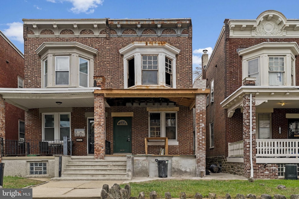
604 E Locust Ave Philadelphia, PA 19144
East Germantown NeighborhoodEstimated payment $932/month
About This Home
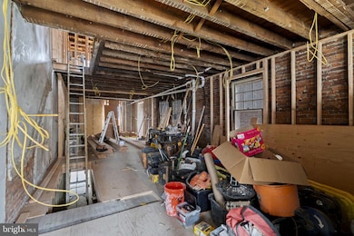
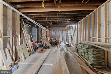
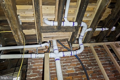
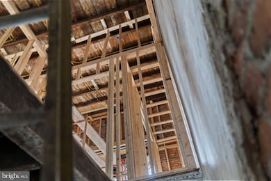
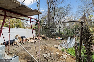
Calling all investors and visionaries to take a look at this twin on 604 E LOCUST STREET. Home has been fully gutted, framed, rough electrical and rough plumbing has been completed. It's waiting for that visionary to come and apply the finising touches to this layout..... 4 bedrooms and 3 full bathrooms. New flat roof was installed in August. For the right investor, completing this project would take 5-8 weeks. Please be advised, that there are no stairs or railings in the interior of the home (upstairs or downstairs). Please proceed with caution. Home is being sold as is. Cash or hard money financing preferred. Bring your contractor vision.
Listing Agent
gtzawolo@yahoo.com Realty Mark Associates License #RS372634 Listed on: 11/13/2025

Townhouse Details
Home Type
- Townhome
Est. Annual Taxes
- $2,358
Year Built
- Built in 1925
Lot Details
- 1,908 Sq Ft Lot
- Lot Dimensions are 19.00 x 100.00
Parking
- On-Street Parking
Home Design
- Semi-Detached or Twin Home
- Brick Foundation
- Masonry
Interior Spaces
- Property has 2 Levels
- Unfinished Basement
- Walk-Out Basement
Bedrooms and Bathrooms
Accessible Home Design
- Doors are 32 inches wide or more
Community Details
- No Home Owners Association
- Germantown Subdivision
Listing and Financial Details
- Tax Lot 117
- Assessor Parcel Number 122061800
Map
Home Values in the Area
Average Home Value in this Area
Tax History
| Year | Tax Paid | Tax Assessment Tax Assessment Total Assessment is a certain percentage of the fair market value that is determined by local assessors to be the total taxable value of land and additions on the property. | Land | Improvement |
|---|---|---|---|---|
| 2026 | $1,712 | $168,500 | $33,700 | $134,800 |
| 2025 | $1,712 | $168,500 | $33,700 | $134,800 |
| 2024 | $1,712 | $168,500 | $33,700 | $134,800 |
| 2023 | $1,712 | $122,300 | $24,460 | $97,840 |
| 2022 | $651 | $122,300 | $24,460 | $97,840 |
| 2021 | $651 | $0 | $0 | $0 |
| 2020 | $651 | $0 | $0 | $0 |
| 2019 | $680 | $0 | $0 | $0 |
| 2018 | $1,211 | $0 | $0 | $0 |
| 2017 | $1,211 | $0 | $0 | $0 |
| 2016 | $1,211 | $0 | $0 | $0 |
| 2015 | $1,159 | $0 | $0 | $0 |
| 2014 | -- | $86,500 | $11,257 | $75,243 |
| 2012 | -- | $7,520 | $2,003 | $5,517 |
Property History
| Date | Event | Price | List to Sale | Price per Sq Ft |
|---|---|---|---|---|
| 11/13/2025 11/13/25 | For Sale | $139,500 | -- | $68 / Sq Ft |
Purchase History
| Date | Type | Sale Price | Title Company |
|---|---|---|---|
| Special Warranty Deed | $55,000 | Choice One Abstract | |
| Deed | -- | -- |
Mortgage History
| Date | Status | Loan Amount | Loan Type |
|---|---|---|---|
| Open | $182,800 | Construction |
Source: Bright MLS
MLS Number: PAPH2559018
APN: 122061800
Disclaimer: Certain information contained herein is derived from information provided by parties other than Homes.com. All information provided is deemed reliable, but is not guaranteed to be accurate and should be independently verified.
![]() The data relating to real estate for sale on this website appears in part through the BRIGHT Internet Data Exchange program, a voluntary cooperative exchange of property listing data between licensed real estate brokerage firms, and is provided by BRIGHT through a licensing agreement.
The data relating to real estate for sale on this website appears in part through the BRIGHT Internet Data Exchange program, a voluntary cooperative exchange of property listing data between licensed real estate brokerage firms, and is provided by BRIGHT through a licensing agreement.
Listing information is from various brokers who participate in the Bright MLS IDX program and not all listings may be visible on the site.
The property information being provided on or through the website is for the personal, non-commercial use of consumers and such information may not be used for any purpose other than to identify prospective properties consumers may be interested in purchasing.
Some properties which appear for sale on the website may no longer be available because they are for instance, under contract, sold or are no longer being offered for sale.
Property information displayed is deemed reliable but is not guaranteed.
Copyright 2025 Bright MLS, Inc.
- 617 E Locust Ave
- 5610 Mcmahon St
- 1000 E Woodlawn St
- 5626 Mcmahon St
- 543 E Locust Ave
- 5625 Crowson St
- 5502 Crowson St
- 616 E Stafford St
- 626 E Stafford St
- 527 E Chelten Ave
- 809 E Locust Ave
- 5688 90 Magnolia St
- 863 E Chelten Ave
- 802 E Chelten Ave
- 436 E Chelten Ave
- 839 E Locust Ave
- 41-43 E Rittenhouse St
- 851 Church Ln
- 740 E Rittenhouse St
- 459 E Price St
- 557 E Church Ln
- 600 E Church Ln
- 710 E Chelten Ave Unit 1
- 5502 Crowson St
- 747 E Woodlawn St
- 5688 90 Magnolia St
- 540 E Penn St
- 363 E Chelten Ave Unit 2
- 849 E Chelten Ave Unit 1
- 849 E Chelten Ave Unit 5
- 2170 Conlyn St
- 525 E Armstrong St Unit 310
- 452 E Mechanic St
- 5504 Devon St
- 430 E High St
- 547 E High St
- 6043 Wister St Unit 1F
- 5581 Blakemore St
- 5524 Matthews St Unit 10
- 5548 Matthews St