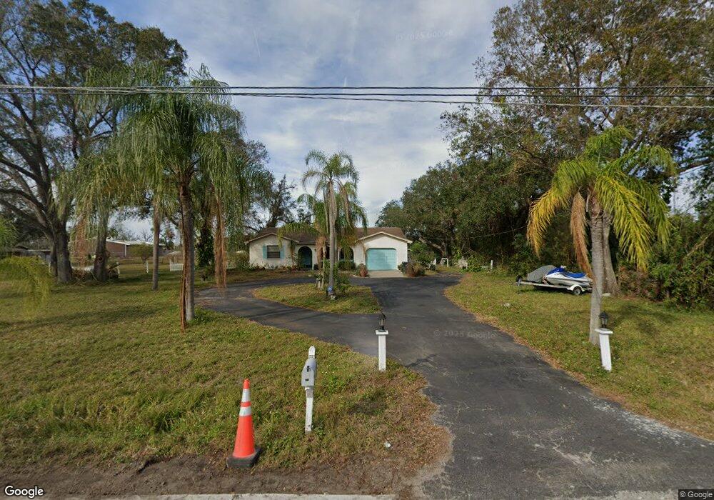
604 E Shell Point Rd Ruskin, FL 33570
Estimated Value: $245,000 - $291,000
2
Beds
2
Baths
1,250
Sq Ft
$214/Sq Ft
Est. Value
About This Home
This home is located at 604 E Shell Point Rd, Ruskin, FL 33570 and is currently estimated at $267,019, approximately $213 per square foot. 604 E Shell Point Rd is a home located in Hillsborough County with nearby schools including Thompson Elementary School, Shields Middle School, and Lennard High School.
Ownership History
Date
Name
Owned For
Owner Type
Purchase Details
Closed on
Apr 14, 2023
Sold by
Edwards Lois Dean
Bought by
Ritchie Roger
Current Estimated Value
Purchase Details
Closed on
Feb 27, 1998
Sold by
Edwards Lois D and Edwards C
Bought by
Edwards Lois D and Jones Brenda R
Purchase Details
Closed on
Mar 12, 1997
Sold by
Mondina Linda A
Bought by
Edwards Lois D
Home Financials for this Owner
Home Financials are based on the most recent Mortgage that was taken out on this home.
Original Mortgage
$29,000
Interest Rate
7.88%
Mortgage Type
New Conventional
Create a Home Valuation Report for This Property
The Home Valuation Report is an in-depth analysis detailing your home's value as well as a comparison with similar homes in the area
Home Values in the Area
Average Home Value in this Area
Purchase History
| Date | Buyer | Sale Price | Title Company |
|---|---|---|---|
| Ritchie Roger | $280,000 | Paramount Title | |
| Edwards Lois D | $100 | -- | |
| Edwards Lois D | $79,000 | -- |
Source: Public Records
Mortgage History
| Date | Status | Borrower | Loan Amount |
|---|---|---|---|
| Previous Owner | Edwards Lois D | $29,000 |
Source: Public Records
Tax History
| Year | Tax Paid | Tax Assessment Tax Assessment Total Assessment is a certain percentage of the fair market value that is determined by local assessors to be the total taxable value of land and additions on the property. | Land | Improvement |
|---|---|---|---|---|
| 2025 | $3,311 | $160,632 | $53,546 | $107,086 |
| 2024 | $3,311 | $158,427 | $49,853 | $108,574 |
| 2023 | $1,046 | $77,244 | $0 | $0 |
| 2022 | $966 | $74,994 | $0 | $0 |
| 2021 | $967 | $72,810 | $0 | $0 |
| 2020 | $908 | $71,805 | $0 | $0 |
| 2019 | $851 | $70,191 | $0 | $0 |
| 2018 | $818 | $68,882 | $0 | $0 |
| 2017 | $811 | $103,643 | $0 | $0 |
| 2016 | $805 | $66,077 | $0 | $0 |
| 2015 | $816 | $65,618 | $0 | $0 |
| 2014 | $799 | $65,097 | $0 | $0 |
| 2013 | -- | $64,135 | $0 | $0 |
Source: Public Records
Map
Nearby Homes
- 508 Glenn Cross Dr
- 525 Glenn Cross Dr
- 714 Barclay Wood Dr
- 501 Delwood Breck St
- 708 Barclay Wood Dr
- 762 Barclay Wood Dr
- 309 Blue Point Dr
- 321 Blue Point Dr
- 506 3rd Ave SE
- 726 Royal Empress Dr
- 736 Royal Empress Dr
- 633 Royal Empress Dr
- 204 E Shell Point Rd
- 928 Royal Empress Dr
- 205 2nd Ave SE
- 0 1st St NE
- 1046 Spotted Egret Loop
- 1005 Spotted Egret Loop
- 1015 Spotted Egret Loop
- 77 E Shell Point Rd
- 604 E Shell Point Rd
- 613 E Shell Point Rd
- 605 E Shell Point Rd
- 705 E Shell Point Rd
- 709 E Shell Point Rd
- 203 6th St NE
- 210 6th St NE
- 702 2nd Ave NE
- 508 E Shell Point Rd
- 303 Delwood Breck St
- 302 Delwood Breck St
- 201 6th St NE
- 206 8th St NE
- 201 6th St NE
- 305 Delwood Breck St
- 202 6th St NE
- 304 Delwood Breck St
- 205 6th St NE
- 307 Delwood Breck St
- 306 Delwood Breck St