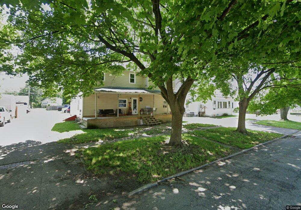
604 Maple St Fostoria, OH 44830
Estimated Value: $94,000 - $129,000
4
Beds
2
Baths
2,408
Sq Ft
$47/Sq Ft
Est. Value
About This Home
This home is located at 604 Maple St, Fostoria, OH 44830 and is currently estimated at $114,300, approximately $47 per square foot. 604 Maple St is a home located in Seneca County with nearby schools including Fostoria Intermediate Elementary School and Fostoria Junior/Senior High School.
Ownership History
Date
Name
Owned For
Owner Type
Purchase Details
Closed on
Aug 21, 2017
Sold by
Babb Rolfe E and Babb Kathy L
Bought by
Nalle Jonathon M and Nalle Lisa M
Current Estimated Value
Purchase Details
Closed on
Sep 10, 2008
Sold by
Nalle Jonathan M
Bought by
Babb Rlfe E and Babb Kathy L
Purchase Details
Closed on
Nov 23, 2007
Sold by
Wells Fargo Bank Na
Bought by
Nalle Jonathon M
Purchase Details
Closed on
Sep 21, 2007
Sold by
Clark Patricia J and Doe John
Bought by
Wells Fargo Bank National Assn
Purchase Details
Closed on
Mar 24, 1998
Sold by
Gallo Joan
Bought by
Clark Patricia J
Purchase Details
Closed on
Jun 26, 1991
Sold by
Kissell Vivian T
Bought by
Gallo Joan
Purchase Details
Closed on
Oct 17, 1990
Create a Home Valuation Report for This Property
The Home Valuation Report is an in-depth analysis detailing your home's value as well as a comparison with similar homes in the area
Home Values in the Area
Average Home Value in this Area
Purchase History
| Date | Buyer | Sale Price | Title Company |
|---|---|---|---|
| Nalle Jonathon M | -- | Attorney | |
| Babb Rlfe E | $17,500 | None Available | |
| Nalle Jonathon M | $18,100 | None Available | |
| Wells Fargo Bank National Assn | $23,334 | None Available | |
| Clark Patricia J | -- | -- | |
| Gallo Joan | $5,500 | -- | |
| -- | -- | -- |
Source: Public Records
Tax History Compared to Growth
Tax History
| Year | Tax Paid | Tax Assessment Tax Assessment Total Assessment is a certain percentage of the fair market value that is determined by local assessors to be the total taxable value of land and additions on the property. | Land | Improvement |
|---|---|---|---|---|
| 2024 | $1,642 | $32,180 | $4,660 | $27,520 |
| 2023 | $1,738 | $32,180 | $4,660 | $27,520 |
| 2022 | $1,517 | $24,210 | $3,860 | $20,350 |
| 2021 | $1,513 | $24,210 | $3,860 | $20,350 |
| 2020 | $5,068 | $24,203 | $3,857 | $20,346 |
| 2019 | $1,480 | $23,363 | $3,724 | $19,639 |
| 2018 | $1,507 | $23,363 | $3,724 | $19,639 |
| 2017 | $1,369 | $23,363 | $3,724 | $19,639 |
| 2016 | $1,250 | $21,144 | $3,966 | $17,178 |
| 2015 | $1,265 | $21,144 | $3,966 | $17,178 |
| 2014 | $1,179 | $21,144 | $3,966 | $17,178 |
| 2013 | $1,274 | $22,981 | $4,312 | $18,669 |
Source: Public Records
Map
Nearby Homes
- 306 E High St
- 520 N Union St
- 505 N Union St
- 321 Mcdougal St
- 325 Mcdougal St
- 207 W Culbertson St
- 711 Circle Dr
- 892 N Countyline St
- 900 N Countyline St
- 1324 N Union St
- 0 W South Route 12
- 625 Jackson Ave
- 508 Short Elm St
- 509 College Ave
- 375 Thomas St
- 619 Foster St
- 461 W Tiffin St
- 620 W North St
- 712 W Tiffin St
- 604 S Union St