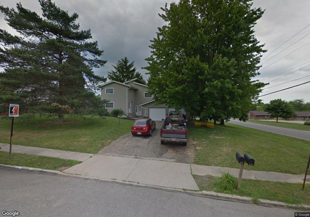
604 Sequoia Ln Mansfield, OH 44904
Estimated Value: $216,000 - $236,000
4
Beds
4
Baths
2,520
Sq Ft
$90/Sq Ft
Est. Value
About This Home
This home is located at 604 Sequoia Ln, Mansfield, OH 44904 and is currently estimated at $226,120, approximately $89 per square foot. 604 Sequoia Ln is a home located in Richland County with nearby schools including Lexington High School, Mansfield Christian School, and Discovery School.
Ownership History
Date
Name
Owned For
Owner Type
Purchase Details
Closed on
Jan 15, 2021
Sold by
Barnhill Daniel L
Bought by
Cooperrider Tom and Cooperrider Ana Christina
Current Estimated Value
Purchase Details
Closed on
Mar 18, 2013
Sold by
The Bank Of New York Mellon
Bought by
Barnhill Daniel L
Purchase Details
Closed on
Oct 26, 2012
Sold by
Twithell Marc C and Case #2012 Cv 0133
Bought by
The Bank Of New York Mellon and The Bank Of New York
Purchase Details
Closed on
Mar 23, 1992
Sold by
Cesare Carol Betty
Bought by
Twitchell Marc C
Create a Home Valuation Report for This Property
The Home Valuation Report is an in-depth analysis detailing your home's value as well as a comparison with similar homes in the area
Home Values in the Area
Average Home Value in this Area
Purchase History
| Date | Buyer | Sale Price | Title Company |
|---|---|---|---|
| Cooperrider Tom | $135,000 | None Available | |
| Barnhill Daniel L | $58,500 | Service Link | |
| The Bank Of New York Mellon | $53,334 | None Available | |
| Twitchell Marc C | $64,000 | -- |
Source: Public Records
Tax History
| Year | Tax Paid | Tax Assessment Tax Assessment Total Assessment is a certain percentage of the fair market value that is determined by local assessors to be the total taxable value of land and additions on the property. | Land | Improvement |
|---|---|---|---|---|
| 2024 | $2,316 | $47,620 | $11,280 | $36,340 |
| 2023 | $2,349 | $47,620 | $11,280 | $36,340 |
| 2022 | $1,891 | $33,010 | $8,520 | $24,490 |
| 2021 | $1,924 | $33,010 | $8,520 | $24,490 |
| 2020 | $1,925 | $33,010 | $8,520 | $24,490 |
| 2019 | $1,770 | $27,980 | $7,220 | $20,760 |
| 2018 | $1,513 | $27,980 | $7,220 | $20,760 |
| 2017 | $1,750 | $32,720 | $7,220 | $25,500 |
| 2016 | $1,138 | $20,850 | $10,080 | $10,770 |
| 2015 | $1,117 | $20,500 | $10,080 | $10,420 |
| 2014 | $1,118 | $20,500 | $10,080 | $10,420 |
| 2012 | $665 | $39,040 | $10,080 | $28,960 |
Source: Public Records
Map
Nearby Homes
- 594 Dirlam Ln
- 615 Bailey Dr
- 1949 Richwood Dr
- 1938 Richwood Dr
- 601 Karlson Dr
- 450 Marwood Dr
- 763 York St W
- 1702 Middle Bellville Rd
- 0 Rippling Brook Dr
- 1689 Middle Bellville Rd
- 1521 Cape Cod Dr
- 680 Weller Ave
- 1637 Cape Cod Dr
- 1490 Hess Cir
- 0 Lot #23132 Hess Cir
- 0 Lot #23127 Hess Cir
- 0 Lot #23139 Hess Cir
- 0 Lot #23121 Hess Cir
- 0 Lot #23133 Hess Cir
- 1485 Overdale Dr
- 602 Sequoia Ln
- 605 Sequoia Ln
- 606 Sequoia Ln
- 1818 Middle Bellville Rd Unit 1820
- 603 Sequoia Ln
- 608 Sequoia Ln
- 607 Sequoia Ln
- 1826 Middle Bellville Rd
- 1823 Sawtooth Place Unit 1825
- 601 Sequoia Ln
- 1812 Middle Bellville Rd Unit 1814
- 609 Sequoia Ln
- 618 Sequoia Ln
- 604 Dirlam Ln
- 1819 Sawtooth Place Unit 1821
- 1886 Mid Bellville Rd Unit 1888
- 608 Dirlam Ln
- 599 Sequoia Ln
- 619 Sequoia Ln
- 598 Dirlam Ln