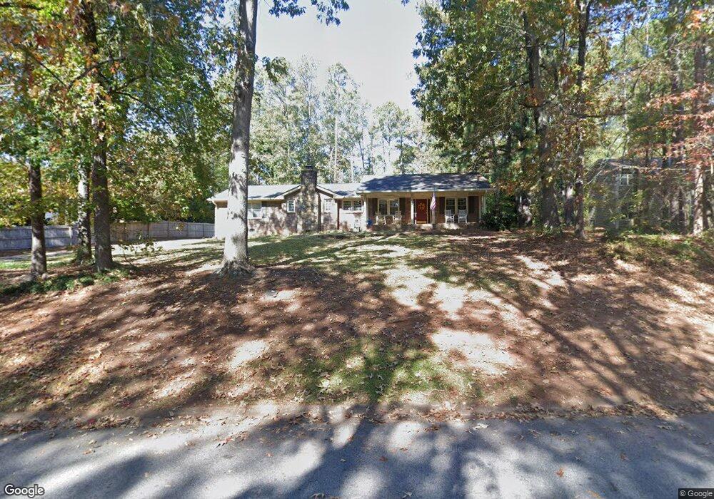
604 Tahoe Dr SE Conyers, GA 30094
Estimated Value: $313,333 - $357,000
4
Beds
3
Baths
2,786
Sq Ft
$121/Sq Ft
Est. Value
About This Home
This home is located at 604 Tahoe Dr SE, Conyers, GA 30094 and is currently estimated at $337,333, approximately $121 per square foot. 604 Tahoe Dr SE is a home located in Rockdale County with nearby schools including Barksdale Elementary School, Gen. Ray Davis Middle School, and Salem High School.
Ownership History
Date
Name
Owned For
Owner Type
Purchase Details
Closed on
Jul 22, 2020
Sold by
Johnson Jane D
Bought by
Johnson Jane D and Johnson James Allen
Current Estimated Value
Purchase Details
Closed on
Apr 5, 2005
Sold by
Miner Donald and Miner Julie
Bought by
Citifinancial Mtg Co
Purchase Details
Closed on
Jun 4, 1999
Sold by
Kent Carlita R
Bought by
Miner Donald and Miner Julie
Home Financials for this Owner
Home Financials are based on the most recent Mortgage that was taken out on this home.
Original Mortgage
$116,000
Interest Rate
7.13%
Mortgage Type
New Conventional
Create a Home Valuation Report for This Property
The Home Valuation Report is an in-depth analysis detailing your home's value as well as a comparison with similar homes in the area
Home Values in the Area
Average Home Value in this Area
Purchase History
| Date | Buyer | Sale Price | Title Company |
|---|---|---|---|
| Johnson Jane D | -- | -- | |
| Citifinancial Mtg Co | $132,500 | -- | |
| Miner Donald | $128,900 | -- |
Source: Public Records
Mortgage History
| Date | Status | Borrower | Loan Amount |
|---|---|---|---|
| Previous Owner | Miner Donald | $116,000 |
Source: Public Records
Tax History Compared to Growth
Tax History
| Year | Tax Paid | Tax Assessment Tax Assessment Total Assessment is a certain percentage of the fair market value that is determined by local assessors to be the total taxable value of land and additions on the property. | Land | Improvement |
|---|---|---|---|---|
| 2024 | $3,120 | $127,440 | $25,360 | $102,080 |
| 2023 | $2,731 | $116,280 | $26,400 | $89,880 |
| 2022 | $2,275 | $98,520 | $22,640 | $75,880 |
| 2021 | $2,073 | $85,480 | $17,040 | $68,440 |
| 2020 | $1,858 | $76,360 | $13,560 | $62,800 |
| 2019 | $1,499 | $63,160 | $10,840 | $52,320 |
| 2018 | $1,404 | $59,800 | $9,680 | $50,120 |
| 2017 | $1,048 | $47,840 | $8,680 | $39,160 |
| 2016 | $968 | $47,840 | $8,680 | $39,160 |
| 2015 | $970 | $47,840 | $8,680 | $39,160 |
| 2014 | $853 | $47,160 | $8,000 | $39,160 |
| 2013 | -- | $60,480 | $12,000 | $48,480 |
Source: Public Records
Map
Nearby Homes
- 2178 NE Hillwood Dr
- 634 Knollwood Cir SE
- 5312 Ashley Dr SE
- 4980 W Lake Dr SE
- 4931 W Lake Dr SE
- 4938 Lake Forest Dr SE
- 4731 Shadybrook Way SE Unit 2
- 4811 W Lake Dr SE
- 801 Greenwood Trail SE
- 1459 Highway 212 SW
- 821 Greenwood Trail SE
- 4970 Hull Rd SE
- 4710 Cedar Brook Dr SE
- 824 Cedar Lake Dr SE
- 4797 Hemlock Dr SE
- 134 Oak Hill West Rd
- 4822 Navajo Trail SE
- 4670 Cedar Brook Dr SE
- 5170 Paul Cir SW
- 614 Tahoe Dr SE
- 601 Tahoe Dr SE
- 601 Tahoe Dr SE
- 0 Tahoe Dr SE Unit 7583543
- 0 Tahoe Dr SE Unit 7539712
- 0 Tahoe Dr SE Unit 7391183
- 0 Tahoe Dr SE Unit 7320075
- 5114 Lake Forest Dr SE
- 5138 Lake Forest Dr SE
- 622 Tahoe Dr SE
- 601 Tahoe Cir SE
- 603 Knollwood Cir SE
- 591 Knollwood Cir SE
- 615 Knollwood Cir SE
- 615 Knollwood Cir SE Unit /24
- 627 Tahoe Dr SE
- 5098 Lake Forest Dr SE
- 581 Tahoe Dr SE
- 581 Tahoe Dr SE
- 5121 Lake Forest Dr SE