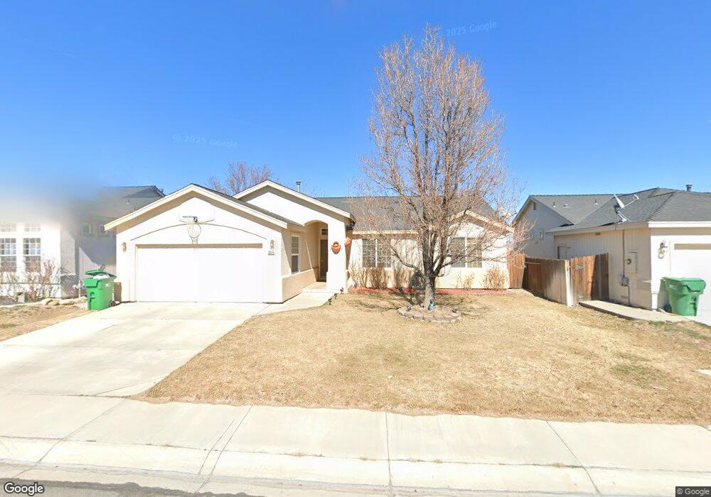
604 Westwinds Dr Dayton, NV 89403
Estimated Value: $391,000 - $419,000
3
Beds
2
Baths
1,390
Sq Ft
$290/Sq Ft
Est. Value
About This Home
This home is located at 604 Westwinds Dr, Dayton, NV 89403 and is currently estimated at $403,658, approximately $290 per square foot. 604 Westwinds Dr is a home located in Lyon County with nearby schools including Sutro Elementary School, Dayton Intermediate School, and Dayton High School.
Ownership History
Date
Name
Owned For
Owner Type
Purchase Details
Closed on
Feb 16, 2005
Sold by
Stone Harris R and Stone Rose Lynn
Bought by
Westom Chad W and Westom Shawna
Current Estimated Value
Home Financials for this Owner
Home Financials are based on the most recent Mortgage that was taken out on this home.
Original Mortgage
$174,000
Outstanding Balance
$87,859
Interest Rate
5.65%
Mortgage Type
New Conventional
Estimated Equity
$315,799
Create a Home Valuation Report for This Property
The Home Valuation Report is an in-depth analysis detailing your home's value as well as a comparison with similar homes in the area
Home Values in the Area
Average Home Value in this Area
Purchase History
| Date | Buyer | Sale Price | Title Company |
|---|---|---|---|
| Westom Chad W | $259,000 | First American Title Co Nv |
Source: Public Records
Mortgage History
| Date | Status | Borrower | Loan Amount |
|---|---|---|---|
| Open | Westom Chad W | $174,000 |
Source: Public Records
Tax History
| Year | Tax Paid | Tax Assessment Tax Assessment Total Assessment is a certain percentage of the fair market value that is determined by local assessors to be the total taxable value of land and additions on the property. | Land | Improvement |
|---|---|---|---|---|
| 2025 | $1,679 | $110,906 | $56,000 | $54,906 |
| 2024 | $1,630 | $111,406 | $56,000 | $55,406 |
| 2023 | $1,630 | $107,990 | $56,000 | $51,990 |
| 2022 | $1,296 | $91,706 | $43,785 | $47,921 |
| 2021 | $1,258 | $90,574 | $43,785 | $46,789 |
| 2020 | $1,221 | $88,661 | $43,790 | $44,871 |
| 2019 | $1,185 | $72,646 | $29,190 | $43,456 |
| 2018 | $1,151 | $63,374 | $21,000 | $42,374 |
| 2017 | $1,117 | $56,402 | $14,000 | $42,402 |
| 2016 | $1,089 | $46,888 | $7,880 | $39,008 |
| 2015 | $1,087 | $36,635 | $7,880 | $28,755 |
| 2014 | $1,055 | $33,040 | $7,880 | $25,160 |
Source: Public Records
Map
Nearby Homes
- 720 Butte Creek Rd
- 737 Butte Creek Rd
- 430 Crosswinds Dr
- 629 Westwinds Dr
- 7013 Highway 50
- 334 Monte Cristo Dr
- 1111 Gold Crater Place Unit Homesite 6
- 209 Corral Dr
- 539 Rawe Peak Dr
- 1115 Gold Crater Place Unit Homesite 8
- 708 Grubbs Well Trail
- 1107 Gold Crater Place Unit Homesite 4
- 1109 Gold Crater Place Unit Homesite 5
- 1103 Gold Crater Place
- 1103 Gold Crater Place Unit Homesite 2
- 1105 Gold Crater Place Unit Homesite 3
- 1105 Gold Crater Place
- 201 Crown Point Dr
- 187 Dayton Village Pkwy
- 260 Green Ln
- 602 Westwinds Dr
- 606 Westwinds Dr
- 600 Westwinds Dr
- 254 Corral Dr
- 523 Windchase Dr
- 610 Westwinds Dr
- 252 Corral Dr
- 521 Windchase Dr
- 264 Corral Dr
- 612 Westwinds Dr
- 611 Westwinds Dr
- 257 Corral Dr
- 519 Windchase Dr
- 259 Corral Dr
- 255 Corral Dr
- 261 Corral Dr
- 253 Corral Dr
- 248 Corral Dr
- 614 Westwinds Dr
- 613 Westwinds Dr
Your Personal Tour Guide
Ask me questions while you tour the home.