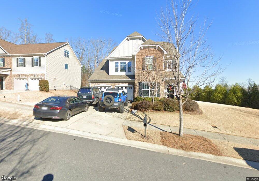
6043 Thorburn Way Belmont, NC 28012
Estimated Value: $563,000 - $594,000
5
Beds
3
Baths
3,490
Sq Ft
$166/Sq Ft
Est. Value
About This Home
This home is located at 6043 Thorburn Way, Belmont, NC 28012 and is currently estimated at $580,626, approximately $166 per square foot. 6043 Thorburn Way is a home with nearby schools including J B Page Elementary School, Belmont Central Elementary School, and Belmont Middle School.
Ownership History
Date
Name
Owned For
Owner Type
Purchase Details
Closed on
Dec 22, 2021
Sold by
Pate Brian D and Pate Traci
Bought by
Pate Brian D
Current Estimated Value
Purchase Details
Closed on
Sep 26, 2013
Sold by
Lennar Carolinas Llc
Bought by
Pate Brian D
Home Financials for this Owner
Home Financials are based on the most recent Mortgage that was taken out on this home.
Original Mortgage
$100,000
Interest Rate
4.39%
Mortgage Type
New Conventional
Create a Home Valuation Report for This Property
The Home Valuation Report is an in-depth analysis detailing your home's value as well as a comparison with similar homes in the area
Home Values in the Area
Average Home Value in this Area
Purchase History
| Date | Buyer | Sale Price | Title Company |
|---|---|---|---|
| Pate Brian D | -- | Vylla Title | |
| Pate Brian D | $244,000 | None Available |
Source: Public Records
Mortgage History
| Date | Status | Borrower | Loan Amount |
|---|---|---|---|
| Previous Owner | Pate Brian D | $100,000 |
Source: Public Records
Tax History Compared to Growth
Tax History
| Year | Tax Paid | Tax Assessment Tax Assessment Total Assessment is a certain percentage of the fair market value that is determined by local assessors to be the total taxable value of land and additions on the property. | Land | Improvement |
|---|---|---|---|---|
| 2025 | $5,636 | $534,700 | $46,000 | $488,700 |
| 2024 | $5,636 | $534,700 | $46,000 | $488,700 |
| 2023 | $5,695 | $534,700 | $46,000 | $488,700 |
| 2022 | $4,491 | $344,150 | $40,000 | $304,150 |
| 2021 | $4,629 | $344,150 | $40,000 | $304,150 |
| 2019 | $4,549 | $335,720 | $40,000 | $295,720 |
| 2018 | $3,567 | $257,553 | $36,000 | $221,553 |
| 2017 | $3,464 | $257,553 | $36,000 | $221,553 |
| 2016 | $3,464 | $257,553 | $0 | $0 |
| 2014 | $3,921 | $291,508 | $55,000 | $236,508 |
Source: Public Records
Map
Nearby Homes
- 6030 Thorburn Way
- 4813 Samuel Pinckney Dr
- 417 Stowe Rd
- 109 James Dr
- 2105 Laurel Village Cir
- 619 R L Stowe Rd
- 5949 Gilchrist Cir
- 651 R L Stowe Rd
- 1250 Hunting Ridge Dr
- 816 S Point Rd
- 806 S Point Rd
- 1507 Cedar Tree Dr
- 1213 Sandra Ct
- 204 Belwood Dr
- 1542 Cedar Tree Dr
- 1075 S Point Rd
- 19 Bowen Dr
- 145 Willerine Dr
- 3131 Channel View Landing
- 2048 Middleton Farm Dr
- 6037 Thorburn Way
- 4819 Samuel Pinckney Dr
- 4819 Samuel Pinckney Dr Unit 107
- 4813 Samuel Pinckney Dr Unit 106
- 6031 Thorburn Way
- 4825 Samuel Pinckney Dr
- 6024 Thorburn Way
- 6018 Thorburn Way
- 6042 Thorburn Way
- 6036 Thorburn Way
- 6025 Thorburn Way
- 4831 Samuel Pinckney Dr Unit 109
- 4831 Samuel Pinckney Dr
- 4831 Pinckney Dr
- 6048 Thorburn Way
- 4818 Samuel Pinckney Dr
- 6019 Thorburn Way
- 3024 Ainsley Ln
- 4812 Samuel Pinckney Dr
- 4824 Samuel Pinckney Dr