Estimated Value: $52,449 - $109,000
--
Bed
--
Bath
985
Sq Ft
$71/Sq Ft
Est. Value
About This Home
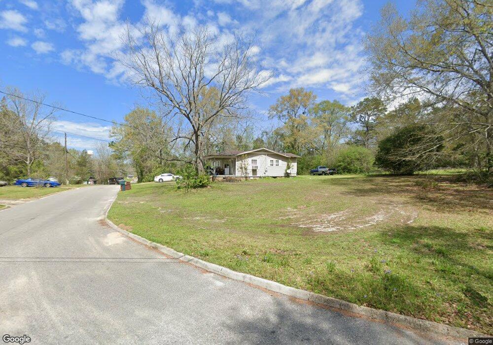
This home is located at 605 4th St, Opp, AL 36467 and is currently estimated at $69,862, approximately $70 per square foot. 605 4th St is a home located in Covington County with nearby schools including Opp Elementary School, Opp Middle School, and Opp High School.
Ownership History
Date
Name
Owned For
Owner Type
Purchase Details
Closed on
Sep 19, 2025
Sold by
Whitt James
Bought by
Bryan John and Bryan Kayla
Current Estimated Value
Purchase Details
Closed on
Dec 6, 2024
Sold by
Nelson Davis C
Bought by
Sixty-Two Financial Group Llc
Purchase Details
Closed on
Mar 22, 2022
Sold by
Lonnie Whitt
Bought by
Whitt James
Purchase Details
Closed on
Apr 29, 2014
Sold by
Whitt James and Whitt Lonnie
Bought by
Whitt Lonnie E
Purchase Details
Closed on
Oct 24, 2011
Sold by
Owens Brittany Diane and Turner Dorothy Nell
Bought by
Whitt Lonnie and Whitt James
Purchase Details
Closed on
Sep 18, 2006
Sold by
Turner Dorothy Nell
Bought by
Owens Brittney Diane
Create a Home Valuation Report for This Property
The Home Valuation Report is an in-depth analysis detailing your home's value as well as a comparison with similar homes in the area
Home Values in the Area
Average Home Value in this Area
Purchase History
| Date | Buyer | Sale Price | Title Company |
|---|---|---|---|
| Bryan John | $4,000 | None Listed On Document | |
| Sixty-Two Financial Group Llc | $5,000 | None Listed On Document | |
| Whitt James | -- | None Listed On Document | |
| Whitt Lonnie E | -- | None Available | |
| Whitt Lonnie | -- | None Available | |
| Owens Brittney Diane | -- | None Available |
Source: Public Records
Tax History Compared to Growth
Tax History
| Year | Tax Paid | Tax Assessment Tax Assessment Total Assessment is a certain percentage of the fair market value that is determined by local assessors to be the total taxable value of land and additions on the property. | Land | Improvement |
|---|---|---|---|---|
| 2024 | $328 | $8,400 | $1,080 | $7,320 |
| 2023 | $328 | $7,212 | $920 | $6,292 |
| 2022 | $268 | $6,852 | $860 | $5,992 |
| 2021 | $225 | $5,760 | $860 | $4,900 |
| 2020 | $225 | $5,760 | $860 | $4,900 |
| 2019 | $229 | $5,880 | $860 | $5,020 |
| 2018 | $229 | $5,880 | $860 | $5,020 |
| 2017 | $218 | $0 | $0 | $0 |
| 2016 | $217 | $0 | $0 | $0 |
| 2015 | $220 | $0 | $0 | $0 |
| 2014 | $220 | $0 | $0 | $0 |
| 2013 | $204 | $5,234 | $864 | $4,370 |
Source: Public Records
Map
Nearby Homes
- 514 Rosalyn Dr
- 811 Maude Ave
- 703 Dorsey St
- TBD 2nd St
- 1003 Maude Ave
- 504 7th St
- 0 Charlie St
- 302 Batten St
- 904 Palmer St
- 300 W Covington Ave
- 404 Barnes St
- 109 Barnes St
- 107 Scott St
- TBD E Cummings Ave
- 114 Foster St
- 114 W Ida Ave
- 209 1/2 W Stewart Ave
- 209 W Stewart Ave
- 211 W Stewart Ave
- 116 Lillie St