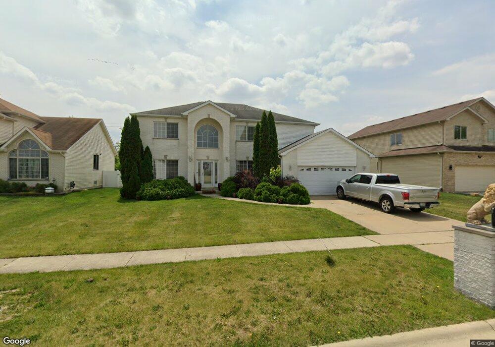
605 Cody Ln University Park, IL 60484
Estimated Value: $277,000 - $320,000
4
Beds
3
Baths
2,592
Sq Ft
$117/Sq Ft
Est. Value
About This Home
This home is located at 605 Cody Ln, University Park, IL 60484 and is currently estimated at $302,875, approximately $116 per square foot. 605 Cody Ln is a home with nearby schools including Talala Elementary School, Crete-Monee Middle School, and Crete-Monee High School.
Ownership History
Date
Name
Owned For
Owner Type
Purchase Details
Closed on
Nov 21, 2005
Sold by
First National Bank Of Illinois
Bought by
Wayne Larry L and Wayne Bettie J
Current Estimated Value
Home Financials for this Owner
Home Financials are based on the most recent Mortgage that was taken out on this home.
Original Mortgage
$255,000
Outstanding Balance
$141,082
Interest Rate
6.2%
Mortgage Type
VA
Estimated Equity
$161,793
Create a Home Valuation Report for This Property
The Home Valuation Report is an in-depth analysis detailing your home's value as well as a comparison with similar homes in the area
Home Values in the Area
Average Home Value in this Area
Purchase History
| Date | Buyer | Sale Price | Title Company |
|---|---|---|---|
| Wayne Larry L | $258,000 | Greater Illinois Title Compa |
Source: Public Records
Mortgage History
| Date | Status | Borrower | Loan Amount |
|---|---|---|---|
| Open | Wayne Larry L | $255,000 |
Source: Public Records
Tax History Compared to Growth
Tax History
| Year | Tax Paid | Tax Assessment Tax Assessment Total Assessment is a certain percentage of the fair market value that is determined by local assessors to be the total taxable value of land and additions on the property. | Land | Improvement |
|---|---|---|---|---|
| 2024 | -- | $94,641 | $14,222 | $80,419 |
| 2023 | -- | $81,587 | $12,260 | $69,327 |
| 2022 | $0 | $71,769 | $10,785 | $60,984 |
| 2021 | $0 | $67,262 | $9,807 | $57,455 |
| 2020 | $3,825 | $62,435 | $9,489 | $52,946 |
| 2019 | $3,825 | $59,209 | $8,999 | $50,210 |
| 2018 | $0 | $56,923 | $8,811 | $48,112 |
| 2017 | $0 | $55,270 | $8,564 | $46,706 |
| 2016 | $0 | $55,622 | $8,234 | $47,388 |
| 2015 | $6,192 | $52,880 | $7,808 | $45,072 |
| 2014 | $6,192 | $53,575 | $7,783 | $45,792 |
| 2013 | $6,192 | $56,100 | $8,150 | $47,950 |
Source: Public Records
Map
Nearby Homes
- 708 Blackhawk Dr
- 713 Circle Dr
- 724 Union Dr
- 523 Circle Dr
- 610 Sandra Dr
- 505 Barbara Ct
- 24625 S Western Ave
- 735 Union Dr
- 807 Blackhawk Dr
- 815 Blackhawk Dr
- 820 Sandra Dr Unit 2C
- 655 Sullivan Ln
- 903 Blackhawk Dr
- 662 Sullivan Ln
- 608 Sullivan Ln
- 786 Delmar Ct Unit 6
- 882 White Oak Ln Unit 3
- 768 Mendocino Ct Unit 5
- 543 Regent Rd
- 766 Mendocino Ct
- 607 Cody Ln
- 603 Cody Ln
- 609 Cody Ln
- 601 Cody Ln
- 694 Cassandra Ln
- 694 Cassendra Ln
- 695 Madisen Ln
- 611 Cody Ln
- 699 Cassendra Ln
- 606 Gordon Terrace
- 692 Cassendra Ln
- 697 Cassendra Ln
- 608 Gordon Terrace
- 693 Madisen Ln
- 602 Gordon Terrace
- 610 Gordon Terrace
- 695 Cassandra Ln
- 600 Gordon Terrace
- 695 Cassendra Ln
- 690 Cassendra Ln