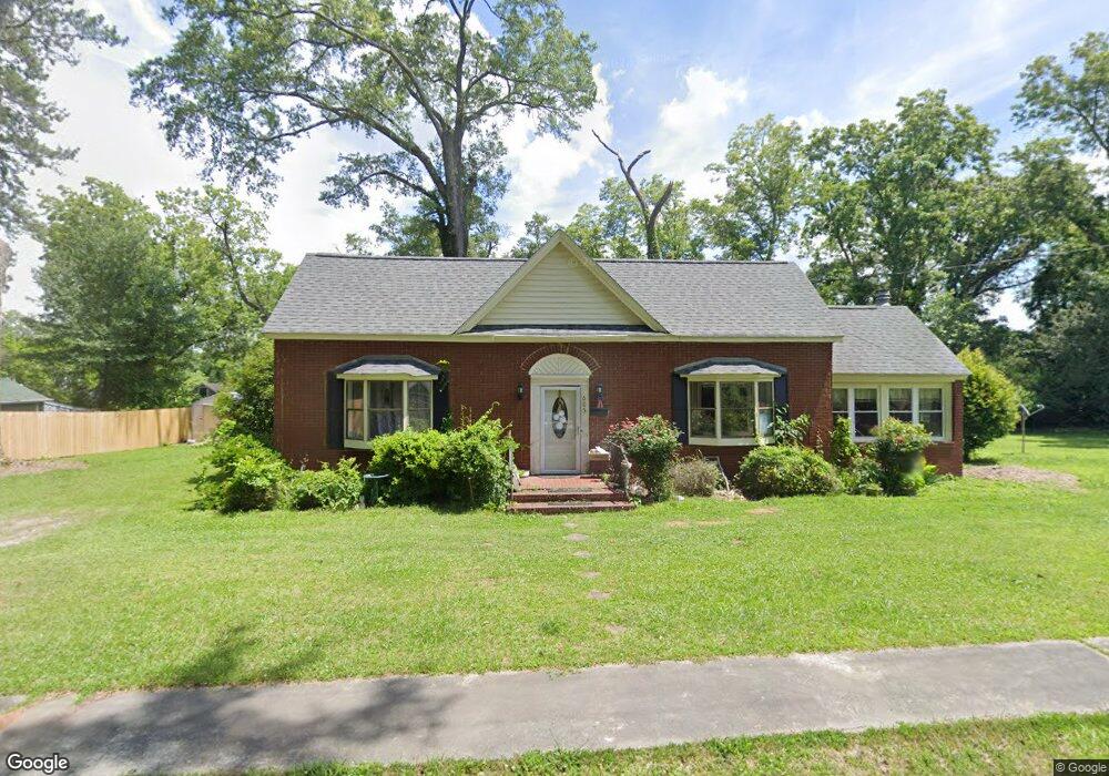
605 Hart Ave Union Point, GA 30669
Estimated Value: $161,000 - $205,000
3
Beds
2
Baths
1,737
Sq Ft
$105/Sq Ft
Est. Value
About This Home
This home is located at 605 Hart Ave, Union Point, GA 30669 and is currently estimated at $181,565, approximately $104 per square foot. 605 Hart Ave is a home located in Greene County with nearby schools including Greene County High School.
Ownership History
Date
Name
Owned For
Owner Type
Purchase Details
Closed on
Dec 7, 2004
Sold by
Graham William A and Graham Cindy L
Bought by
Flynn Cindy Leigh-Divorce--
Current Estimated Value
Purchase Details
Closed on
Feb 9, 1999
Sold by
Brook John C
Bought by
Graham William A and Graham Cindy L
Purchase Details
Closed on
Oct 19, 1994
Sold by
Hawk Robert P
Bought by
Brook John C
Purchase Details
Closed on
Jan 1, 1975
Sold by
Couch Danny S and Couch Regina
Bought by
Hawk Robert P
Purchase Details
Closed on
Jan 1, 1971
Sold by
Durham Mercer C
Bought by
Couch Danny S and Couch Regina
Purchase Details
Closed on
Jan 1, 1968
Sold by
Durham Nell Wright
Bought by
Durham Mercer C
Purchase Details
Closed on
Jan 1, 1967
Sold by
Wright M C Mrs
Bought by
Durham Nell Wright
Purchase Details
Closed on
Jan 1, 1961
Bought by
Wright M C Mrs
Create a Home Valuation Report for This Property
The Home Valuation Report is an in-depth analysis detailing your home's value as well as a comparison with similar homes in the area
Purchase History
| Date | Buyer | Sale Price | Title Company |
|---|---|---|---|
| Flynn Cindy Leigh-Divorce-- | -- | -- | |
| Graham William A | $71,100 | -- | |
| Brook John C | $55,000 | -- | |
| Hawk Robert P | -- | -- | |
| Couch Danny S | -- | -- | |
| Durham Mercer C | -- | -- | |
| Durham Nell Wright | -- | -- | |
| Wright M C Mrs | -- | -- |
Source: Public Records
Tax History
| Year | Tax Paid | Tax Assessment Tax Assessment Total Assessment is a certain percentage of the fair market value that is determined by local assessors to be the total taxable value of land and additions on the property. | Land | Improvement |
|---|---|---|---|---|
| 2025 | $924 | $46,320 | $3,840 | $42,480 |
| 2024 | $898 | $42,800 | $3,840 | $38,960 |
| 2023 | $340 | $40,960 | $3,840 | $37,120 |
| 2022 | $587 | $37,752 | $3,840 | $33,912 |
| 2021 | $612 | $33,712 | $3,840 | $29,872 |
| 2020 | $543 | $20,800 | $3,360 | $17,440 |
| 2019 | $560 | $20,800 | $3,360 | $17,440 |
| 2018 | $421 | $20,800 | $3,360 | $17,440 |
| 2017 | $505 | $20,833 | $3,375 | $17,458 |
| 2016 | $531 | $21,810 | $3,375 | $18,435 |
| 2015 | $498 | $21,810 | $3,375 | $18,435 |
| 2014 | $503 | $21,562 | $3,375 | $18,187 |
Source: Public Records
Map
Nearby Homes
- 202 Veazey St
- 607 Bryan Ave
- 324 N Rhodes St
- 405 Crawfordville Rd
- 0 Woodland Ct Unit 10543600
- 215 Hunter St
- 0 S Rhodes St Unit 10618488
- 1160 Moody St
- 1041 Hillcrest Dr
- 000 Washington Hwy
- 1241 Old Siloam Rd
- 1581 Highway 77 S Hwy
- 1581 Highway 77 S
- 5401 Union Point Hwy
- 1201 Buffalo Lick Rd
- 0 Buffalo Lick Rd Unit 10551234
- 0 Buffalo Lick Rd Unit 10551325
- 1251 Adams Rd
- 0 Old Union Point Rd Unit 1 10557753
- 1251 Brick House Rd
Your Personal Tour Guide
Ask me questions while you tour the home.