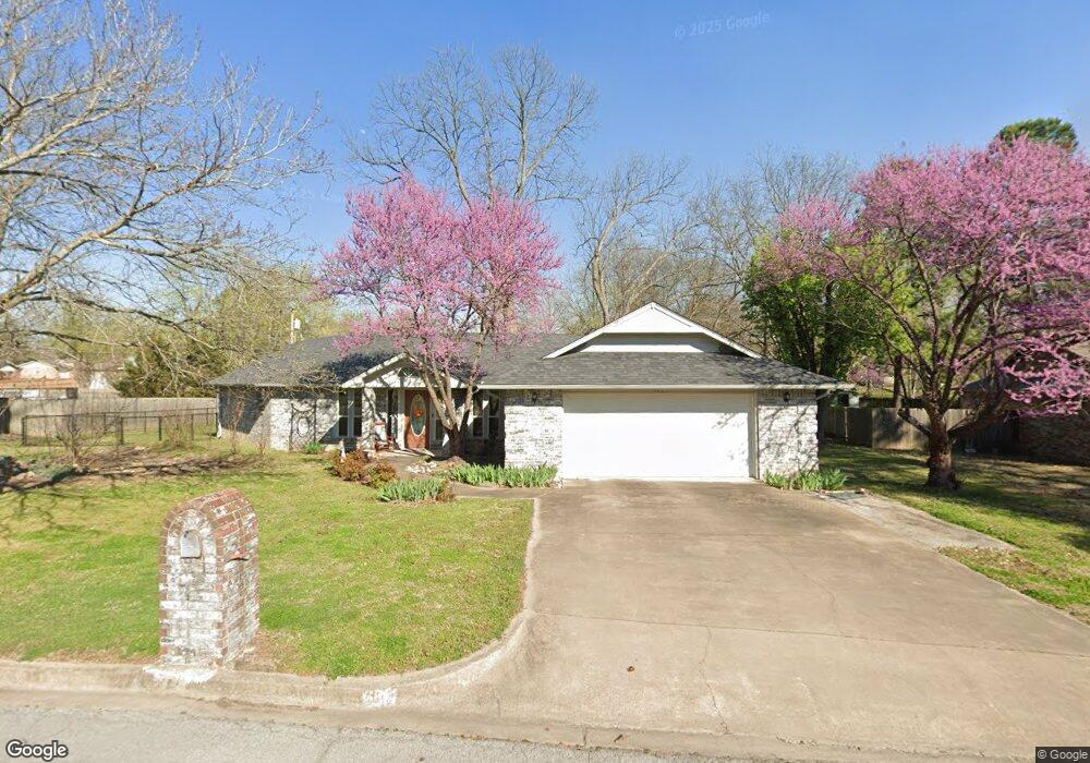
605 May Ave Tahlequah, OK 74464
Estimated Value: $220,965 - $257,000
3
Beds
2
Baths
1,785
Sq Ft
$133/Sq Ft
Est. Value
About This Home
This home is located at 605 May Ave, Tahlequah, OK 74464 and is currently estimated at $236,741, approximately $132 per square foot. 605 May Ave is a home located in Cherokee County with nearby schools including Greenwood Elementary School, Cherokee Elementary School, and Tahlequah Middle School.
Ownership History
Date
Name
Owned For
Owner Type
Purchase Details
Closed on
Feb 24, 2020
Sold by
Presley Hazel Sue
Bought by
Presley Hazel S and Presley Richard Donna
Current Estimated Value
Purchase Details
Closed on
Feb 24, 2019
Sold by
Presley Hazel Sue
Bought by
Presley Hazel S and Presley Mark A
Purchase Details
Closed on
May 10, 2013
Sold by
Mcintosh Donna Sue and Richard Steanen Livain
Bought by
Richard Donna Sue and Richard Stephen Livain
Purchase Details
Closed on
May 19, 2006
Sold by
Trapp Paul Edward and Fears Grace Frances
Bought by
Dorothy F Trapp Trust
Purchase Details
Closed on
Feb 4, 1994
Sold by
Paul and Louise Crosslin
Bought by
Robert W & Peggy V Coop
Create a Home Valuation Report for This Property
The Home Valuation Report is an in-depth analysis detailing your home's value as well as a comparison with similar homes in the area
Home Values in the Area
Average Home Value in this Area
Purchase History
| Date | Buyer | Sale Price | Title Company |
|---|---|---|---|
| Presley Hazel S | -- | None Available | |
| Presley Hazel S | -- | None Available | |
| Richard Donna Sue | -- | None Available | |
| Dorothy F Trapp Trust | -- | None Available | |
| Robert W & Peggy V Coop | $12,000 | -- |
Source: Public Records
Tax History Compared to Growth
Tax History
| Year | Tax Paid | Tax Assessment Tax Assessment Total Assessment is a certain percentage of the fair market value that is determined by local assessors to be the total taxable value of land and additions on the property. | Land | Improvement |
|---|---|---|---|---|
| 2025 | $1,668 | $18,859 | $1,219 | $17,640 |
| 2024 | $1,771 | $19,693 | $1,219 | $18,474 |
| 2023 | $1,771 | $19,376 | $1,142 | $18,234 |
| 2022 | $1,653 | $18,811 | $1,108 | $17,703 |
| 2021 | $1,608 | $18,263 | $1,076 | $17,187 |
| 2020 | $1,586 | $17,731 | $1,045 | $16,686 |
| 2019 | $1,523 | $17,214 | $1,014 | $16,200 |
| 2018 | $1,494 | $16,714 | $1,093 | $15,621 |
| 2017 | $1,445 | $16,227 | $1,061 | $15,166 |
| 2016 | $1,409 | $15,755 | $974 | $14,781 |
| 2015 | $1,342 | $15,296 | $1,111 | $14,185 |
| 2014 | $1,304 | $14,850 | $1,221 | $13,629 |
Source: Public Records
Map
Nearby Homes
- 702 Wilson Ave
- 201 Sandy Cir
- 306 Short St
- 413 Greenwood Dr
- 757 S Bluff Ave
- 508 Covington Place
- 605 S Oak Ave
- 403 S Bluff Ave
- 215 S Maple Ave
- 1105 S Maple Ave
- 802 S College Ave
- 720 S East Ave
- 1290 E 4th St
- 510 S Cherokee Ave
- 215 E Fuller St
- 224 W Chickasaw St
- 1005 Kaufman Ave
- 513 S State Ave
- 104 Tommye Ln
- 516 W Fox St