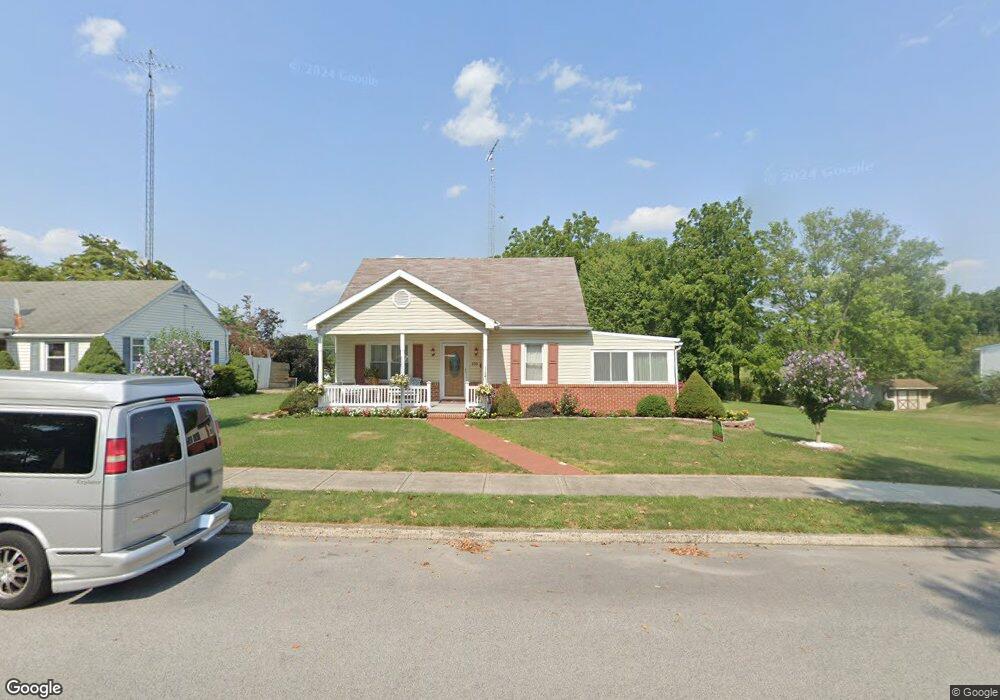
605 Prince St Littlestown, PA 17340
Estimated Value: $279,000 - $336,000
4
Beds
2
Baths
2,046
Sq Ft
$146/Sq Ft
Est. Value
About This Home
This home is located at 605 Prince St, Littlestown, PA 17340 and is currently estimated at $298,673, approximately $145 per square foot. 605 Prince St is a home located in Adams County with nearby schools including Rolling Acres El School, Maple Avenue Middle School, and Littlestown Senior High School.
Ownership History
Date
Name
Owned For
Owner Type
Purchase Details
Closed on
Jan 8, 2024
Sold by
Arthur L And Marie G Barnes Family Trust
Bought by
Arthur L And Marie G Barnes Family Trust and Barnes
Current Estimated Value
Purchase Details
Closed on
Jan 18, 2021
Sold by
Barner Arthur L and Barner Marie G
Bought by
Barnes Arthur L and Barnes Marie G
Purchase Details
Closed on
Jan 1, 1963
Bought by
Barnes Arthur L and Barnes Marie G
Create a Home Valuation Report for This Property
The Home Valuation Report is an in-depth analysis detailing your home's value as well as a comparison with similar homes in the area
Home Values in the Area
Average Home Value in this Area
Purchase History
| Date | Buyer | Sale Price | Title Company |
|---|---|---|---|
| Arthur L And Marie G Barnes Family Trust | -- | None Listed On Document | |
| Arthur L And Marie G Barnes Family Trust | -- | None Listed On Document | |
| Barnes Arthur L | -- | None Available | |
| Barnes Arthur L | $10,500 | -- |
Source: Public Records
Tax History
| Year | Tax Paid | Tax Assessment Tax Assessment Total Assessment is a certain percentage of the fair market value that is determined by local assessors to be the total taxable value of land and additions on the property. | Land | Improvement |
|---|---|---|---|---|
| 2025 | $4,696 | $204,300 | $33,600 | $170,700 |
| 2024 | $4,526 | $204,300 | $33,600 | $170,700 |
| 2023 | $4,201 | $197,300 | $26,600 | $170,700 |
| 2022 | $4,176 | $197,300 | $26,600 | $170,700 |
| 2021 | $4,052 | $197,300 | $26,600 | $170,700 |
| 2020 | $4,004 | $197,300 | $26,600 | $170,700 |
| 2019 | $3,884 | $197,300 | $26,600 | $170,700 |
| 2018 | $3,813 | $197,300 | $26,600 | $170,700 |
| 2017 | $3,715 | $197,300 | $26,600 | $170,700 |
| 2016 | -- | $197,300 | $26,600 | $170,700 |
| 2015 | -- | $197,300 | $26,600 | $170,700 |
| 2014 | -- | $197,300 | $26,600 | $170,700 |
Source: Public Records
Map
Nearby Homes
- 21 Johnamac N Unit 384
- 0 Locust Dr Unit PAAD2015910
- 20c Locust Dr
- 162 Newark St
- 61 Stoners Cir
- 5160 Baltimore Pike Unit 3
- 102 N Queen St
- 68 Maple Ave
- 20 Stedtle Ave
- 72 Patrick Ave
- 149 W Myrtle St
- 620 Saint Johns Rd
- 41 Smith Cir
- 141 W King St
- 115 Charles St
- 144 W King St
- 117 Charles St
- 149 Lumber St
- 161 Cemetery St
- 22 Cemetery St
- 609 Prince St
- 613 Prince St Unit 50
- 529 Prince St Unit 74
- 523 Prince St
- 610 Prince St
- 602 Prince St Unit 59
- 619 Prince St Unit 51
- 532 Prince St Unit 61
- 528 Prince St Unit 62
- 519 Prince St
- 524 Prince St Unit 63
- 513 Prince St Unit 44
- 520 Prince St Unit 64
- 516 Prince St
- 2225 White Hall Rd
- 509 Prince St
- 512 Prince St
- 5356 Baltimore Pike
- 505 Prince St
- 22 Carroll St
Your Personal Tour Guide
Ask me questions while you tour the home.