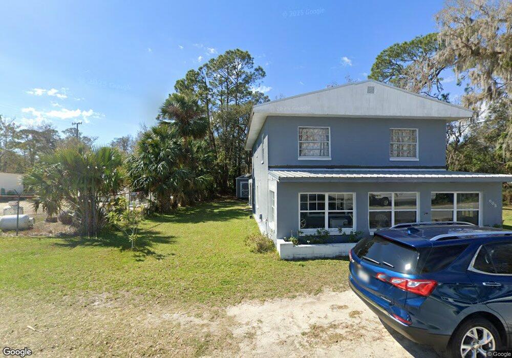
605 S Railroad St Bunnell, FL 32110
Estimated Value: $161,189 - $448,000
4
Beds
1
Bath
2,964
Sq Ft
$89/Sq Ft
Est. Value
About This Home
This home is located at 605 S Railroad St, Bunnell, FL 32110 and is currently estimated at $264,797, approximately $89 per square foot. 605 S Railroad St is a home with nearby schools including Bunnell Elementary School, Buddy Taylor Middle School, and Flagler-Palm Coast High School.
Ownership History
Date
Name
Owned For
Owner Type
Purchase Details
Closed on
Jul 24, 2017
Sold by
Walker Louise Mccall and Crowley Martina
Bought by
Walker Louise Mccall and Crowley Martina Mccall
Current Estimated Value
Purchase Details
Closed on
Jul 20, 2017
Sold by
Brown Roosevelt Clyde
Bought by
Crowley Martina
Purchase Details
Closed on
Nov 16, 2009
Sold by
Walker Louise
Bought by
Hall James and Brown Roosevelt Clyde
Purchase Details
Closed on
Sep 4, 2009
Sold by
Walker Louise and Brown Roosevelt Clyde
Bought by
Walker Louise
Purchase Details
Closed on
Jul 17, 2002
Sold by
Walker Louise and Brown Roosevelt Clyde
Bought by
Walker Louise and Brown Roosevelt Clyde
Create a Home Valuation Report for This Property
The Home Valuation Report is an in-depth analysis detailing your home's value as well as a comparison with similar homes in the area
Home Values in the Area
Average Home Value in this Area
Purchase History
| Date | Buyer | Sale Price | Title Company |
|---|---|---|---|
| Walker Louise Mccall | -- | Attorney | |
| Crowley Martina | -- | Attorney | |
| Hall James | -- | Attorney | |
| Walker Louise | -- | Attorney | |
| Walker Louise | -- | -- |
Source: Public Records
Tax History Compared to Growth
Tax History
| Year | Tax Paid | Tax Assessment Tax Assessment Total Assessment is a certain percentage of the fair market value that is determined by local assessors to be the total taxable value of land and additions on the property. | Land | Improvement |
|---|---|---|---|---|
| 2024 | $763 | $80,621 | -- | -- |
| 2023 | $763 | $78,273 | $0 | $0 |
| 2022 | $707 | $75,993 | $0 | $0 |
| 2021 | $697 | $73,780 | $0 | $0 |
| 2020 | $674 | $72,761 | $0 | $0 |
| 2019 | $670 | $70,465 | $0 | $0 |
| 2018 | $675 | $69,151 | $8,250 | $60,901 |
| 2017 | $1,510 | $65,090 | $8,250 | $56,840 |
| 2016 | $761 | $57,270 | $0 | $0 |
| 2015 | $745 | $56,360 | $0 | $0 |
| 2014 | $716 | $54,807 | $0 | $0 |
Source: Public Records
Map
Nearby Homes
- 401 S Church St
- 300 S Church St
- 0 Sherman St
- 00 Sherman St
- 507 S Anderson St
- 604 Hymon Cir
- 401 Hibiscus Ave
- 504 E Lambert St
- 504 N Cherry St
- 228 N Orange St Unit A
- 0 Chapel St Unit MFRC7495018
- 2095 Grove St
- xx E Woodland St
- 651 Old Haw Creek Rd
- 708 N Chapel St
- 604 Fourth St
- 7 Grand Par Ct
- 15 Grand Par Ct
- 2315 E Moody Blvd
- 32 Grand Par Ct
- 601 S State St
- 305 S Bay St
- 601 S Bay St
- 0 S Bay St Unit 1130983
- 00 S Bay St
- 0000 S Bay St
- 0 S Bay St
- 508 N Railroad St
- 700 S State St
- 510 S State St
- 505 S Bay St
- 0 S Highway Us 1 Unit O5027851
- 0 S Highway Us 1 Unit O5137624
- 602 S State St Unit C
- 602 S State St Unit B
- 602 S State St
- 808 S State St
- 45 Doctor Martin Luther King Jr Ave
- 00 Us 1 S
- 209 Us Highway 1 S