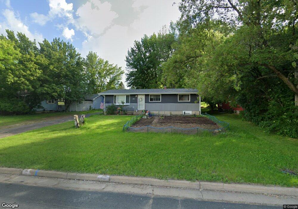
605 Spring St Somerset, WI 54025
Estimated Value: $258,000 - $291,000
3
Beds
1
Bath
1,056
Sq Ft
$260/Sq Ft
Est. Value
About This Home
This home is located at 605 Spring St, Somerset, WI 54025 and is currently estimated at $274,781, approximately $260 per square foot. 605 Spring St is a home located in St. Croix County with nearby schools including Somerset Elementary School, Somerset Middle School, and Somerset High School.
Ownership History
Date
Name
Owned For
Owner Type
Purchase Details
Closed on
Oct 1, 2018
Sold by
Maf Rentals Llc
Bought by
Martin Kevin and Martin Mandi
Current Estimated Value
Home Financials for this Owner
Home Financials are based on the most recent Mortgage that was taken out on this home.
Original Mortgage
$164,900
Outstanding Balance
$143,803
Interest Rate
4.5%
Mortgage Type
New Conventional
Estimated Equity
$130,978
Purchase Details
Closed on
Aug 29, 2017
Sold by
Trt Faust Michael A and Trt Michael A Faust Revocable
Bought by
Maf Rentals Llc
Purchase Details
Closed on
Jun 1, 2016
Sold by
Lais Debra J
Bought by
Faust Michael A and Michael A Faust Revocable Trus
Home Financials for this Owner
Home Financials are based on the most recent Mortgage that was taken out on this home.
Original Mortgage
$100,000
Interest Rate
3.59%
Mortgage Type
Seller Take Back
Create a Home Valuation Report for This Property
The Home Valuation Report is an in-depth analysis detailing your home's value as well as a comparison with similar homes in the area
Home Values in the Area
Average Home Value in this Area
Purchase History
| Date | Buyer | Sale Price | Title Company |
|---|---|---|---|
| Martin Kevin | $170,000 | Abstracts & Titles | |
| Maf Rentals Llc | -- | -- | |
| Faust Michael A | $125,000 | Attorney |
Source: Public Records
Mortgage History
| Date | Status | Borrower | Loan Amount |
|---|---|---|---|
| Open | Martin Kevin | $164,900 | |
| Previous Owner | Faust Michael A | $100,000 |
Source: Public Records
Tax History Compared to Growth
Tax History
| Year | Tax Paid | Tax Assessment Tax Assessment Total Assessment is a certain percentage of the fair market value that is determined by local assessors to be the total taxable value of land and additions on the property. | Land | Improvement |
|---|---|---|---|---|
| 2024 | $27 | $157,000 | $30,500 | $126,500 |
| 2023 | $2,560 | $157,000 | $30,500 | $126,500 |
| 2022 | $2,440 | $157,000 | $30,500 | $126,500 |
| 2021 | $2,348 | $157,000 | $30,500 | $126,500 |
| 2020 | $2,342 | $149,000 | $30,500 | $118,500 |
| 2019 | $2,484 | $102,500 | $21,500 | $81,000 |
| 2018 | $2,339 | $102,500 | $21,500 | $81,000 |
| 2017 | $2,288 | $102,500 | $21,500 | $81,000 |
| 2016 | $2,288 | $102,500 | $21,500 | $81,000 |
| 2015 | $2,270 | $102,500 | $21,500 | $81,000 |
| 2014 | $2,216 | $102,500 | $21,500 | $81,000 |
| 2013 | $2,223 | $102,500 | $21,500 | $81,000 |
Source: Public Records
Map
Nearby Homes
- 108 Main St
- 325 Church Hill Rd
- 270 Main St
- 302 Main St
- 486 Meadow Ln
- 206 Red Pine Dr
- 316 Evergreen Dr
- 441 White Pine Ln
- 314 Cedar St
- 441 Charles Ln
- 481 Martin Way
- 315 Harriman St
- 357 Harriman St
- 1932 64th St
- XXXX 50th St
- The Rockport Plan at Pine Vale
- The Newport Plan at Pine Vale
- The Brook View Plan at Pine Vale
- The Cheyenne Plan at Pine Vale
- The Ashton Plan at Pine Vale