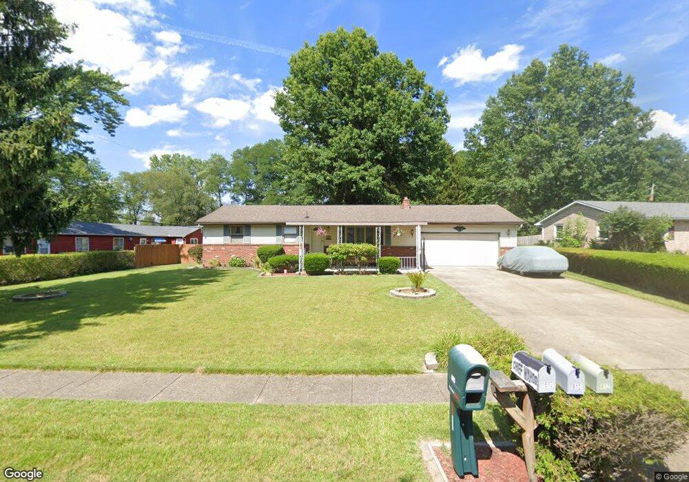
605 Taff Cir Louisville, OH 44641
Estimated Value: $221,000 - $239,000
3
Beds
2
Baths
1,170
Sq Ft
$198/Sq Ft
Est. Value
About This Home
This home is located at 605 Taff Cir, Louisville, OH 44641 and is currently estimated at $231,589, approximately $197 per square foot. 605 Taff Cir is a home located in Stark County with nearby schools including Louisville High School and St. Thomas Aquinas High School & Middle School.
Ownership History
Date
Name
Owned For
Owner Type
Purchase Details
Closed on
Sep 29, 1998
Sold by
Miskimens Everett J
Bought by
Simon Robert E and Simon Stephanie L
Current Estimated Value
Home Financials for this Owner
Home Financials are based on the most recent Mortgage that was taken out on this home.
Original Mortgage
$60,000
Outstanding Balance
$13,239
Interest Rate
6.99%
Mortgage Type
New Conventional
Estimated Equity
$218,350
Purchase Details
Closed on
Nov 17, 1992
Create a Home Valuation Report for This Property
The Home Valuation Report is an in-depth analysis detailing your home's value as well as a comparison with similar homes in the area
Home Values in the Area
Average Home Value in this Area
Purchase History
| Date | Buyer | Sale Price | Title Company |
|---|---|---|---|
| Simon Robert E | $92,000 | -- | |
| -- | $75,000 | -- |
Source: Public Records
Mortgage History
| Date | Status | Borrower | Loan Amount |
|---|---|---|---|
| Open | Simon Robert E | $60,000 |
Source: Public Records
Tax History Compared to Growth
Tax History
| Year | Tax Paid | Tax Assessment Tax Assessment Total Assessment is a certain percentage of the fair market value that is determined by local assessors to be the total taxable value of land and additions on the property. | Land | Improvement |
|---|---|---|---|---|
| 2025 | -- | $67,200 | $21,700 | $45,500 |
| 2024 | -- | $67,200 | $21,700 | $45,500 |
| 2023 | $2,458 | $57,200 | $21,530 | $35,670 |
| 2022 | $2,464 | $57,200 | $21,530 | $35,670 |
| 2021 | $2,471 | $57,200 | $21,530 | $35,670 |
| 2020 | $2,044 | $51,380 | $19,390 | $31,990 |
| 2019 | $2,052 | $51,390 | $19,390 | $32,000 |
| 2018 | $2,045 | $51,390 | $19,390 | $32,000 |
| 2017 | $1,873 | $45,410 | $15,860 | $29,550 |
| 2016 | $1,911 | $45,410 | $15,860 | $29,550 |
| 2015 | $1,917 | $45,410 | $15,860 | $29,550 |
| 2014 | $1,779 | $39,170 | $13,690 | $25,480 |
| 2013 | $893 | $39,170 | $13,690 | $25,480 |
Source: Public Records
Map
Nearby Homes
- 908 Sand Lot Cir
- 1702 View Pointe Ave
- 1639 Horizon Dr
- 510 S Bauman Ct
- 520 S Silver St
- 728 E Broad St
- 641 S Nickelplate St
- 204 E Broad St
- 107 E Broad St
- 308 Superior St
- 1715 High St
- 8225 Georgetown St
- 1812 E Broad St
- 2110 Edmar St
- 325 Lincoln Ave
- 0 Michigan Blvd
- 3390 Meese Rd NE
- 6969 Georgetown St NE
- 201 Indiana Ave
- 2425 Miday Ave NE