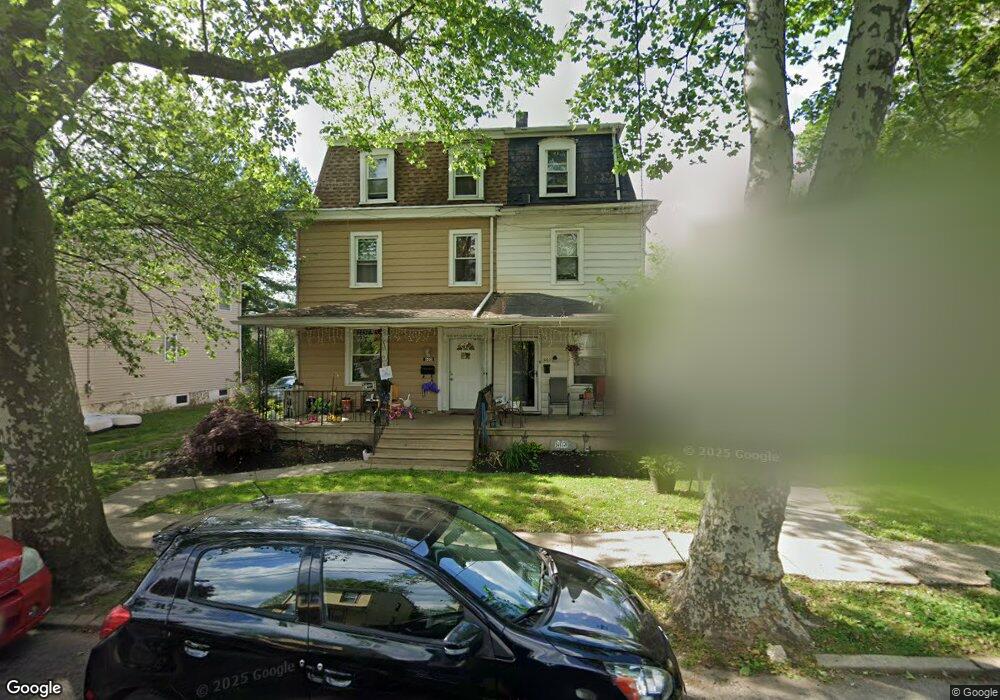
605 W 6th St Palmyra, NJ 08065
Estimated Value: $291,000 - $380,000
4
Beds
2
Baths
1,870
Sq Ft
$174/Sq Ft
Est. Value
About This Home
This home is located at 605 W 6th St, Palmyra, NJ 08065 and is currently estimated at $325,097, approximately $173 per square foot. 605 W 6th St is a home located in Burlington County with nearby schools including Charles Street School, Palmyra Middle School, and Palmyra High School.
Ownership History
Date
Name
Owned For
Owner Type
Purchase Details
Closed on
Mar 31, 2017
Sold by
Gould Alan I and Law Michael L
Bought by
Daniel Mark Properties Llc
Current Estimated Value
Home Financials for this Owner
Home Financials are based on the most recent Mortgage that was taken out on this home.
Original Mortgage
$90,000
Outstanding Balance
$75,077
Interest Rate
4.3%
Mortgage Type
Commercial
Estimated Equity
$250,020
Purchase Details
Closed on
Apr 15, 2008
Sold by
Anthony Mark L and Anthony Lavern
Bought by
Law Michael L
Home Financials for this Owner
Home Financials are based on the most recent Mortgage that was taken out on this home.
Original Mortgage
$1,000,000
Interest Rate
5.99%
Mortgage Type
Credit Line Revolving
Purchase Details
Closed on
Nov 27, 2001
Sold by
Roland S Perry Estate and Anthony Lavern
Bought by
Anthony Mark L and Anthony Lavern
Create a Home Valuation Report for This Property
The Home Valuation Report is an in-depth analysis detailing your home's value as well as a comparison with similar homes in the area
Home Values in the Area
Average Home Value in this Area
Purchase History
| Date | Buyer | Sale Price | Title Company |
|---|---|---|---|
| Daniel Mark Properties Llc | $130,000 | City Abstract | |
| Law Michael L | $70,000 | Foundation Title | |
| Anthony Mark L | -- | -- |
Source: Public Records
Mortgage History
| Date | Status | Borrower | Loan Amount |
|---|---|---|---|
| Open | Daniel Mark Properties Llc | $90,000 | |
| Previous Owner | Law Michael L | $1,000,000 |
Source: Public Records
Tax History Compared to Growth
Tax History
| Year | Tax Paid | Tax Assessment Tax Assessment Total Assessment is a certain percentage of the fair market value that is determined by local assessors to be the total taxable value of land and additions on the property. | Land | Improvement |
|---|---|---|---|---|
| 2025 | $5,176 | $119,700 | $35,400 | $84,300 |
| 2024 | $5,068 | $119,700 | $35,400 | $84,300 |
| 2023 | $5,068 | $119,700 | $35,400 | $84,300 |
| 2022 | $4,948 | $119,700 | $35,400 | $84,300 |
| 2021 | $4,776 | $119,700 | $35,400 | $84,300 |
| 2020 | $4,794 | $119,700 | $35,400 | $84,300 |
| 2019 | $4,643 | $119,700 | $35,400 | $84,300 |
| 2018 | $4,577 | $119,700 | $35,400 | $84,300 |
| 2017 | $4,519 | $119,700 | $35,400 | $84,300 |
| 2016 | $4,430 | $119,700 | $35,400 | $84,300 |
| 2015 | $4,367 | $119,700 | $35,400 | $84,300 |
| 2014 | $4,174 | $119,700 | $35,400 | $84,300 |
Source: Public Records
Map
Nearby Homes
- 523 W 5th St
- 308 W 3rd St
- 403 W Broad St
- 279 Arch St
- 313 Race St
- 309 W 5th St
- 525 Front St
- 223 Horace Ave
- 412 Horace Ave
- 162 Oxford Rd
- 223 Temple Blvd
- 419 Leconey Ave
- 321 Leconey Ave
- 168 Fairfax Dr
- 3059 Harbour Dr Unit 3059
- 111 Temple Blvd
- 105 Leconey Cir
- 150 Fairfax Dr
- 832 Cinnaminson Ave
- 2193 Harbour Dr Unit 2193