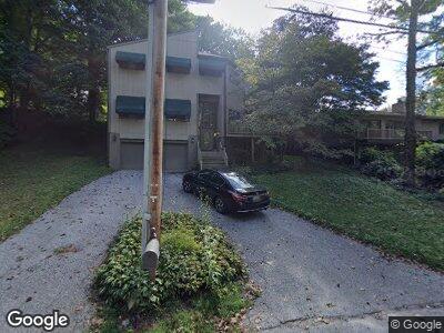
605 W Chesapeake Ave Towson, MD 21204
Southland Hills NeighborhoodEstimated Value: $697,000 - $826,000
--
Bed
4
Baths
3,312
Sq Ft
$231/Sq Ft
Est. Value
About This Home
This home is located at 605 W Chesapeake Ave, Towson, MD 21204 and is currently estimated at $766,485, approximately $231 per square foot. 605 W Chesapeake Ave is a home located in Baltimore County with nearby schools including West Towson Elementary School, Dumbarton Middle School, and Towson High Law & Public Policy.
Ownership History
Date
Name
Owned For
Owner Type
Purchase Details
Closed on
Mar 6, 2003
Sold by
Mccormick Michael B
Bought by
National Equity Inc
Current Estimated Value
Purchase Details
Closed on
Aug 14, 2001
Sold by
Spicer Malcolm F
Bought by
Mccormick Michael B and Mccormick Peggy A
Purchase Details
Closed on
Feb 21, 1986
Sold by
Koman Investment S Inc
Bought by
Spicer Malcolm F
Create a Home Valuation Report for This Property
The Home Valuation Report is an in-depth analysis detailing your home's value as well as a comparison with similar homes in the area
Home Values in the Area
Average Home Value in this Area
Purchase History
| Date | Buyer | Sale Price | Title Company |
|---|---|---|---|
| National Equity Inc | $350,000 | -- | |
| Mccormick Michael B | $315,000 | -- | |
| Spicer Malcolm F | $180,000 | -- |
Source: Public Records
Mortgage History
| Date | Status | Borrower | Loan Amount |
|---|---|---|---|
| Open | Owens Alison Taylor | $80,000 |
Source: Public Records
Tax History Compared to Growth
Tax History
| Year | Tax Paid | Tax Assessment Tax Assessment Total Assessment is a certain percentage of the fair market value that is determined by local assessors to be the total taxable value of land and additions on the property. | Land | Improvement |
|---|---|---|---|---|
| 2024 | $6,958 | $499,367 | $0 | $0 |
| 2023 | $3,464 | $495,533 | $0 | $0 |
| 2022 | $6,730 | $491,700 | $121,800 | $369,900 |
| 2021 | $7,188 | $489,733 | $0 | $0 |
| 2020 | $7,188 | $487,767 | $0 | $0 |
| 2019 | $6,999 | $485,800 | $121,800 | $364,000 |
| 2018 | $6,691 | $463,833 | $0 | $0 |
| 2017 | $6,471 | $441,867 | $0 | $0 |
| 2016 | $6,361 | $419,900 | $0 | $0 |
| 2015 | $6,361 | $419,900 | $0 | $0 |
| 2014 | $6,361 | $419,900 | $0 | $0 |
Source: Public Records
Map
Nearby Homes
- 7 Hampshire Woods Ct
- 22 Stone Manor Ct
- 609 Marwood Rd
- 400 Alabama Rd
- 11 Florida Rd
- 437 Alabama Rd
- 502 Alabama Rd
- 809 Loyola Dr
- 533 Park Ave
- 500 W Joppa Rd
- 28 Allegheny Ave Unit 1901
- 28 Allegheny Ave Unit 2503
- 28 Allegheny Ave Unit 1210
- 28 Allegheny Ave Unit 1504
- 28 Allegheny Ave Unit 2201
- 28 Allegheny Ave Unit 1903-1905
- 16 Linden Terrace
- 303 Davage Ln
- 6 Cedar Ave
- 423 E Jefferson Ave
- 605 W Chesapeake Ave
- 607 W Chesapeake Ave
- 609 W Chesapeake Ave
- 601 W Chesapeake Ave
- 603 W Chesapeake Ave
- 13 Hampshire Woods Ct
- 15 Hampshire Woods Ct
- 611 W Chesapeake Ave
- 15 Burnbrae Rd
- 17 Hampshire Woods Ct
- 9 Hampshire Woods Ct
- 302 Alabama Rd
- 300 Alabama Rd
- 12 Burnbrae Rd
- 613 W Chesapeake Ave
- 304 Alabama Rd
- 5 Hampshire Woods Ct
- 9 Burnbrae Rd
- 16 Hampshire Woods Ct
- 3 Hampshire Woods Ct
