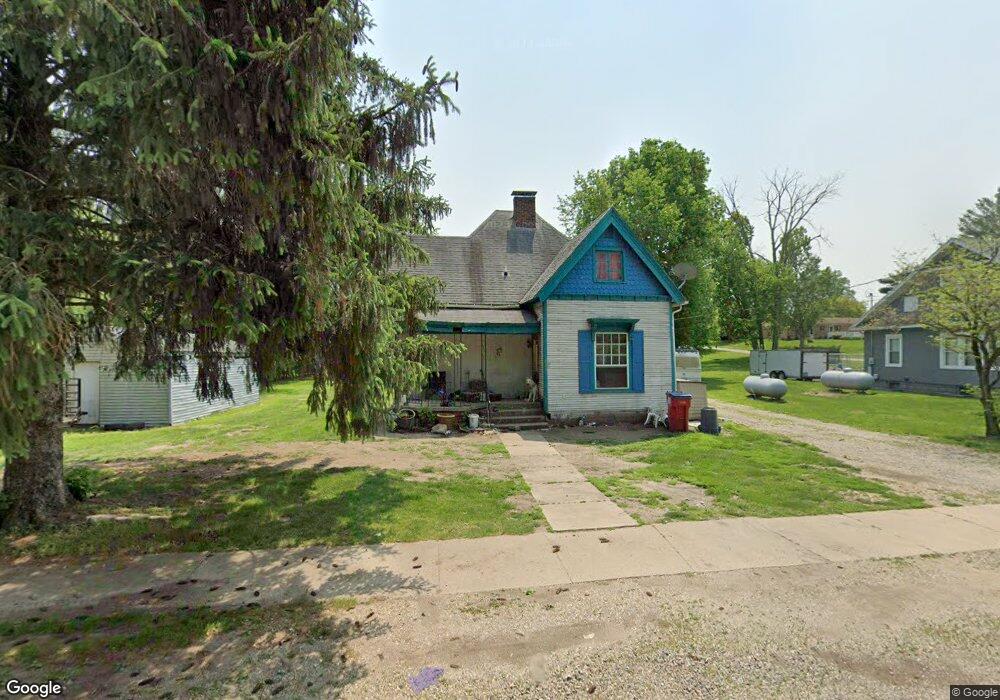
605 W Curtis St Cayuga, IN 47928
Estimated Value: $123,000 - $143,000
3
Beds
1
Bath
1,250
Sq Ft
$105/Sq Ft
Est. Value
About This Home
This home is located at 605 W Curtis St, Cayuga, IN 47928 and is currently estimated at $130,735, approximately $104 per square foot. 605 W Curtis St is a home located in Vermillion County with nearby schools including North Vermillion Elementary School, North Vermillion High School, and RESCARE RESIDENTIAL PROGRAM.
Ownership History
Date
Name
Owned For
Owner Type
Purchase Details
Closed on
Apr 1, 2019
Sold by
Castlerock 2017 Llc
Bought by
Castle Cfd Group Llc
Current Estimated Value
Purchase Details
Closed on
Nov 20, 2017
Sold by
Deutsche Bank National Trust Co
Bought by
Castlerock 2017 Llc
Purchase Details
Closed on
May 22, 2017
Sold by
Vermillion County (In) Sheriff
Bought by
Deutsche Bank National Trust Co
Purchase Details
Closed on
May 11, 2017
Sold by
Michael
Bought by
See
Create a Home Valuation Report for This Property
The Home Valuation Report is an in-depth analysis detailing your home's value as well as a comparison with similar homes in the area
Home Values in the Area
Average Home Value in this Area
Purchase History
| Date | Buyer | Sale Price | Title Company |
|---|---|---|---|
| Castle Cfd Group Llc | -- | None Available | |
| Castlerock 2017 Llc | $7,300 | -- | |
| Deutsche Bank National Trust Co | $60,350 | -- | |
| See | $60,400 | -- |
Source: Public Records
Tax History Compared to Growth
Tax History
| Year | Tax Paid | Tax Assessment Tax Assessment Total Assessment is a certain percentage of the fair market value that is determined by local assessors to be the total taxable value of land and additions on the property. | Land | Improvement |
|---|---|---|---|---|
| 2024 | $1,571 | $78,300 | $11,700 | $66,600 |
| 2023 | $1,572 | $78,600 | $11,700 | $66,900 |
| 2022 | $1,524 | $74,000 | $6,500 | $67,500 |
| 2021 | $1,353 | $65,600 | $8,000 | $57,600 |
| 2020 | $1,356 | $65,700 | $8,000 | $57,700 |
| 2019 | $1,071 | $51,900 | $8,000 | $43,900 |
| 2018 | $1,071 | $51,900 | $8,000 | $43,900 |
| 2017 | $1,064 | $51,500 | $8,000 | $43,500 |
| 2016 | $1,036 | $50,100 | $8,000 | $42,100 |
| 2014 | $1,064 | $51,700 | $8,000 | $43,700 |
| 2013 | $1,064 | $51,900 | $8,000 | $43,900 |
Source: Public Records
Map
Nearby Homes
- 304 S Seventh St
- 402 W Maple St
- 219 N Wabash St
- 908 S Division St
- 0 State Road 234
- 7796 N Meridian Rd
- 9015 Indiana 63
- 2340 W Hibbs Rd
- 3148 S Coffing Brothers Rd
- 0000 Vacant Grd S Main St
- 0 1000 N
- 1 1000 N
- 1000 N 300 W
- 0 1000 N Unit LotWP001
- 1938 W
- 2503 W Bunkertown Rd
- 22715 E 2650th Rd
- 402 W Walnut St
- 1985 S Towpath Rd
- 504 S Seminary St
- 609 W Curtis St
- 603 W Curtis St
- 604 W Curtis St
- 610 W Curtis St
- 602 W Curtis St
- 703 W Curtis St
- 700 W Curtis St
- 702 W Elm St
- 509 W Curtis St
- 709 W Curtis St
- 704 W Elm St
- 706 W Curtis St
- 701 W Elm St
- 510 W Curtis St
- 204 S 7th St
- 110 6th St
- 711 W Curtis St
- 502 W Curtis St
- 205 W Court Dr
- 712 W Curtis St