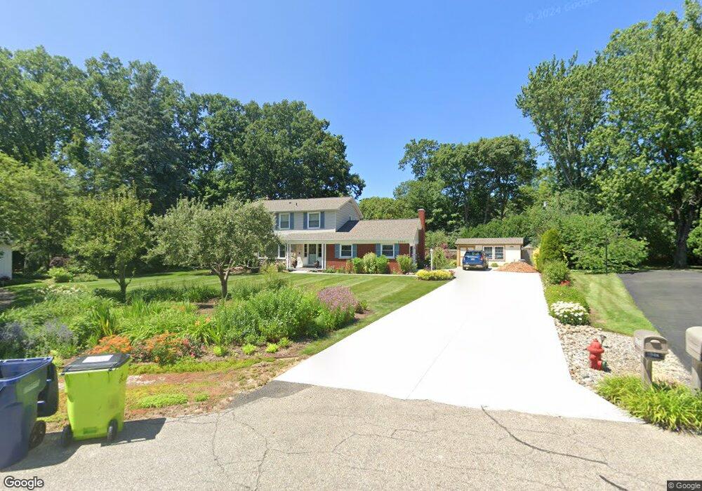
6050 Wellesley Ct West Bloomfield, MI 48322
Estimated Value: $393,000 - $441,000
4
Beds
3
Baths
2,001
Sq Ft
$208/Sq Ft
Est. Value
About This Home
This home is located at 6050 Wellesley Ct, West Bloomfield, MI 48322 and is currently estimated at $417,063, approximately $208 per square foot. 6050 Wellesley Ct is a home located in Oakland County with nearby schools including Sheiko Elementary School, West Bloomfield Middle School, and Maria Montessori Center.
Ownership History
Date
Name
Owned For
Owner Type
Purchase Details
Closed on
May 20, 2013
Sold by
Kemp David B and Kemp Denise M
Bought by
The David B Kemp & Denise M Kemp Revocab
Current Estimated Value
Purchase Details
Closed on
Dec 21, 1995
Sold by
Homovec Drew
Bought by
Kemp David B
Home Financials for this Owner
Home Financials are based on the most recent Mortgage that was taken out on this home.
Original Mortgage
$184,500
Outstanding Balance
$3,742
Interest Rate
7.28%
Estimated Equity
$413,321
Create a Home Valuation Report for This Property
The Home Valuation Report is an in-depth analysis detailing your home's value as well as a comparison with similar homes in the area
Home Values in the Area
Average Home Value in this Area
Purchase History
| Date | Buyer | Sale Price | Title Company |
|---|---|---|---|
| The David B Kemp & Denise M Kemp Revocab | -- | None Available | |
| Kemp David B | $205,000 | -- |
Source: Public Records
Mortgage History
| Date | Status | Borrower | Loan Amount |
|---|---|---|---|
| Open | Kemp David B | $184,500 |
Source: Public Records
Tax History Compared to Growth
Tax History
| Year | Tax Paid | Tax Assessment Tax Assessment Total Assessment is a certain percentage of the fair market value that is determined by local assessors to be the total taxable value of land and additions on the property. | Land | Improvement |
|---|---|---|---|---|
| 2024 | $2,431 | $157,790 | $0 | $0 |
| 2022 | $2,328 | $141,450 | $34,100 | $107,350 |
| 2021 | $3,537 | $139,190 | $0 | $0 |
| 2020 | $2,281 | $135,570 | $34,100 | $101,470 |
| 2018 | $3,410 | $117,330 | $29,600 | $87,730 |
| 2015 | -- | $96,110 | $0 | $0 |
| 2014 | -- | $87,510 | $0 | $0 |
| 2011 | -- | $84,370 | $0 | $0 |
Source: Public Records
Map
Nearby Homes
- 6151 Orchard Lake Rd Unit 103
- 3865 Stonecrest Rd
- 6109 Orchard Lake Rd Unit 101
- 6145 Orchard Lake Rd Unit 204
- 5780 Swan Lake Ct
- 5622 Powder Horn Dr
- 6322 Pepper Hill St Unit 62
- 6222 Pepper Hill St
- 5946 Cherry Crest Dr
- 6624 Mellow Wood Ln
- 3035 Parkland Dr
- 4161 Breckenridge Dr
- 3930 Harris Ln
- 5415 Fairway Ln
- 5321 Fairway Ln Unit 7
- 3104 Spring St
- 6769 Heather Heath
- 6843 Leslee Crest Dr
- 6564 Alderley Way
- 4117 Marlwood Dr
- 6060 Wellesley Ct
- 5916 Saint James Dr
- 6051 Wellesley Ct
- 5930 Saint James Dr
- 6031 Wellesley Dr
- 5908 Saint James Dr
- 6061 Wellesley Ct
- 5944 Saint James Dr
- 6078 Wellesley Ct
- 6071 Wellesley Dr
- 6077 Wellesley Ct
- 6032 Cochise Dr
- 6052 Cochise Dr
- 5958 Saint James Dr
- 5925 Saint James Dr
- 6094 Wellesley Ct
- 6095 Wellesley Dr
- 5935 Saint James Dr
- 5911 Saint James Dr
- 6038 Wellesley Dr