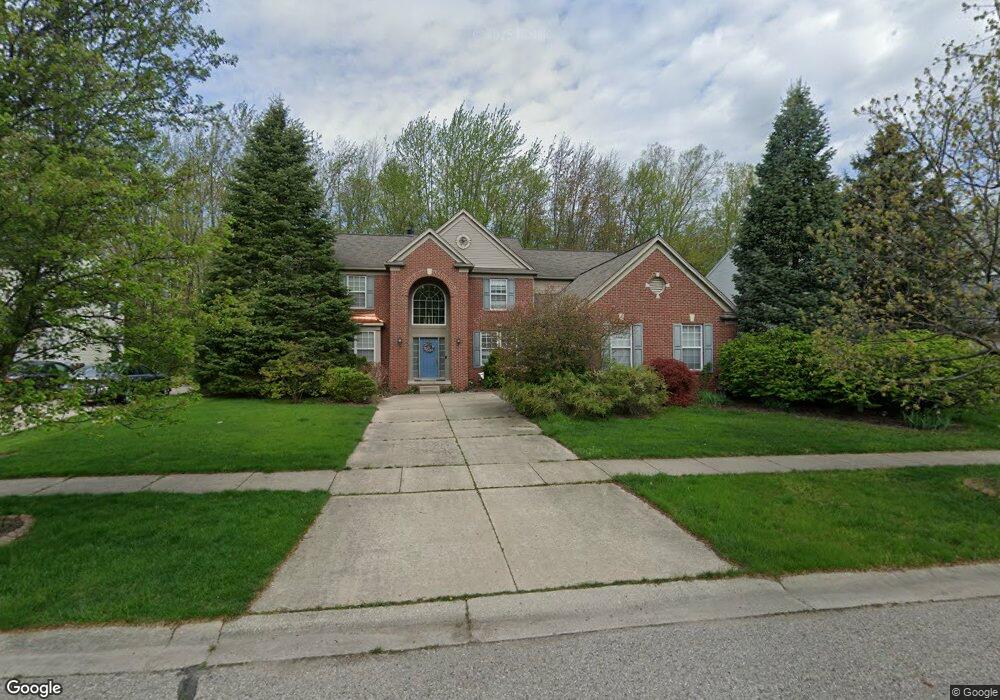
6056 Eagle Trace Dr Ypsilanti, MI 48197
Estimated Value: $461,167 - $512,000
4
Beds
3
Baths
2,900
Sq Ft
$168/Sq Ft
Est. Value
About This Home
This home is located at 6056 Eagle Trace Dr, Ypsilanti, MI 48197 and is currently estimated at $486,792, approximately $167 per square foot. 6056 Eagle Trace Dr is a home located in Washtenaw County with nearby schools including Lincoln Senior High School, East Arbor Charter Academy, and Pittsfield Acres Academy.
Ownership History
Date
Name
Owned For
Owner Type
Purchase Details
Closed on
May 29, 2008
Sold by
Dye David B
Bought by
The Bank Of New York Trust Co Na and Jpmorgan Chase Bank Usa
Current Estimated Value
Purchase Details
Closed on
Apr 28, 2005
Sold by
Paquette Mark A and Paquette Kerry A
Bought by
Dye David B
Purchase Details
Closed on
Apr 22, 2002
Sold by
Pulte Land Company L L C
Bought by
Paquette Mark A
Create a Home Valuation Report for This Property
The Home Valuation Report is an in-depth analysis detailing your home's value as well as a comparison with similar homes in the area
Home Values in the Area
Average Home Value in this Area
Purchase History
| Date | Buyer | Sale Price | Title Company |
|---|---|---|---|
| The Bank Of New York Trust Co Na | $234,000 | None Available | |
| Dye David B | $321,000 | Metropolitan Title Company | |
| Paquette Mark A | $205,500 | -- |
Source: Public Records
Tax History
| Year | Tax Paid | Tax Assessment Tax Assessment Total Assessment is a certain percentage of the fair market value that is determined by local assessors to be the total taxable value of land and additions on the property. | Land | Improvement |
|---|---|---|---|---|
| 2025 | $4,714 | $233,100 | $0 | $0 |
| 2024 | $4,290 | $219,300 | $0 | $0 |
| 2023 | $3,858 | $183,800 | $0 | $0 |
| 2022 | $3,682 | $174,800 | $0 | $0 |
| 2021 | $6,234 | $168,500 | $0 | $0 |
| 2020 | $6,164 | $162,100 | $0 | $0 |
| 2019 | $2,593 | $151,900 | $151,900 | $0 |
| 2018 | $0 | $152,400 | $0 | $0 |
| 2017 | $5,630 | $149,800 | $0 | $0 |
| 2016 | $3,391 | $116,514 | $0 | $0 |
| 2015 | $5,323 | $116,166 | $0 | $0 |
| 2014 | $5,323 | $112,537 | $0 | $0 |
| 2013 | -- | $112,537 | $0 | $0 |
Source: Public Records
Map
Nearby Homes
- 6243 Eagle Trace Ct
- 8084 Creek Bend Dr
- 6122 Cherrywood Dr
- 5695 Caren Dr
- 8350 Thornhill Dr
- 5880 Whittaker Rd
- 7435 Textile Rd
- 7816 Pleasant Ln
- 7850 S Huron River Dr
- 7843 Briarbrook Dr
- 5193 Textile Rd
- 5490 Scott Ct
- 7985 Faircrest Dr
- 7015 Merritt Rd
- 8797 Lilly Dr
- 7034 Hogan Dr
- 8501 Martz Rd
- 7258 Royal Troon Dr
- 6315 Sequoia Dr
- 7511 Bermuda Dunes
- 6072 Eagle Trace Dr
- 6040 Eagle Trace Dr
- 6098 Eagle Trace Dr
- 6022 Eagle Trace Dr
- 0 Eagle Trace Dr
- 6041 Eagle Trace Dr
- 6114 Eagle Trace Dr
- 6010 Eagle Trace Dr
- 7875 Breezewood Ct
- 6130 Eagle Trace Dr
- 7984 Pebblestone Dr
- 6021 Eagle Trace Dr
- 7887 Breezewood Ct
- 7992 Pebblestone Dr
- 6142 Eagle Trace Dr
- 7770 Textile Rd
- 7979 Pebblestone Dr
- 6011 Eagle Trace Dr
- 7899 Breezewood Ct
- 8000 Pebblestone Dr
Your Personal Tour Guide
Ask me questions while you tour the home.