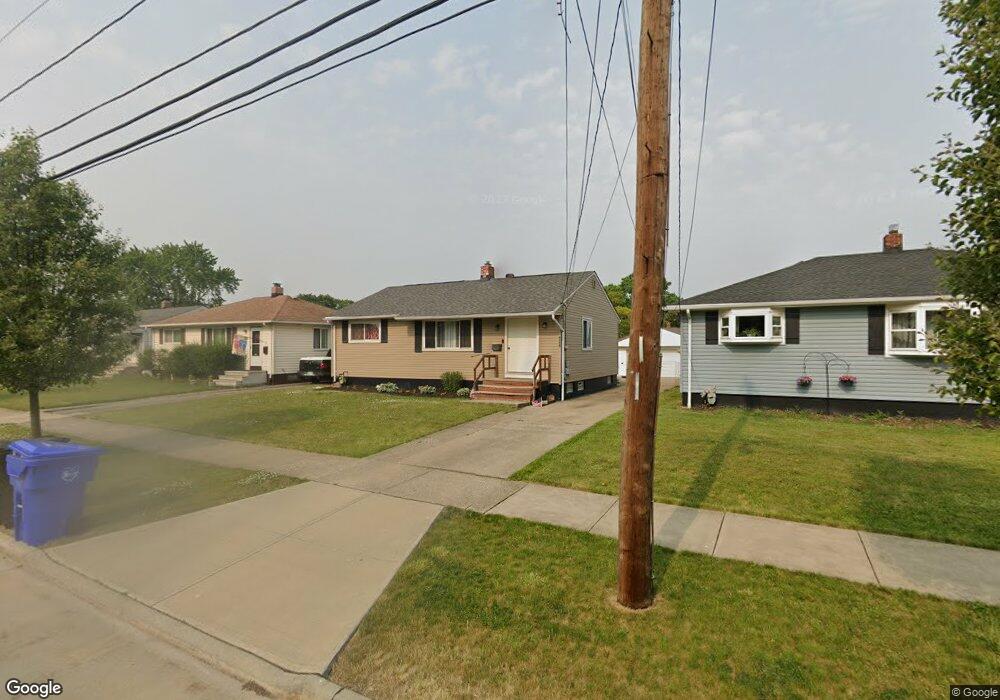
6058 Fry Rd Brookpark, OH 44142
Estimated Value: $190,296 - $218,000
3
Beds
1
Bath
936
Sq Ft
$222/Sq Ft
Est. Value
About This Home
This home is located at 6058 Fry Rd, Brookpark, OH 44142 and is currently estimated at $207,574, approximately $221 per square foot. 6058 Fry Rd is a home located in Cuyahoga County with nearby schools including Berea-Midpark Middle School, Berea-Midpark High School, and Huber Heights Preparatory Academy Parma Academy.
Ownership History
Date
Name
Owned For
Owner Type
Purchase Details
Closed on
Mar 14, 2022
Sold by
Dennis Klubnik
Bought by
Klubnik Dennis Michael
Current Estimated Value
Home Financials for this Owner
Home Financials are based on the most recent Mortgage that was taken out on this home.
Original Mortgage
$104,250
Outstanding Balance
$97,226
Interest Rate
3.76%
Mortgage Type
New Conventional
Estimated Equity
$110,348
Purchase Details
Closed on
May 16, 1984
Sold by
Klubnik Calvin G and Klubnik Diane L
Bought by
Klubnik Calvin G
Purchase Details
Closed on
Sep 12, 1979
Bought by
Klubnik Calvin G and Klubnik Diane L
Purchase Details
Closed on
Jun 5, 1979
Sold by
Crosby Robert M and Crosby Geraldine
Bought by
Cleary Realty Company
Purchase Details
Closed on
Jan 1, 1975
Bought by
Crosby Robert M and Crosby Geraldine
Create a Home Valuation Report for This Property
The Home Valuation Report is an in-depth analysis detailing your home's value as well as a comparison with similar homes in the area
Home Values in the Area
Average Home Value in this Area
Purchase History
| Date | Buyer | Sale Price | Title Company |
|---|---|---|---|
| Klubnik Dennis Michael | -- | Thompson Paul | |
| Klubnik Dennis M | $60,000 | Thompson Paul | |
| Klubnik Calvin G | -- | -- | |
| Klubnik Calvin G | $52,500 | -- | |
| Cleary Realty Company | $49,500 | -- | |
| Crosby Robert M | -- | -- |
Source: Public Records
Mortgage History
| Date | Status | Borrower | Loan Amount |
|---|---|---|---|
| Open | Klubnik Dennis M | $104,250 |
Source: Public Records
Tax History Compared to Growth
Tax History
| Year | Tax Paid | Tax Assessment Tax Assessment Total Assessment is a certain percentage of the fair market value that is determined by local assessors to be the total taxable value of land and additions on the property. | Land | Improvement |
|---|---|---|---|---|
| 2024 | $2,497 | $48,440 | $10,080 | $38,360 |
| 2023 | $2,461 | $39,520 | $8,160 | $31,360 |
| 2022 | $2,444 | $39,520 | $8,160 | $31,360 |
| 2021 | $2,431 | $39,520 | $8,160 | $31,360 |
| 2020 | $2,193 | $31,360 | $6,480 | $24,890 |
| 2019 | $2,079 | $89,600 | $18,500 | $71,100 |
| 2018 | $1,971 | $31,360 | $6,480 | $24,890 |
| 2017 | $2,026 | $28,360 | $6,340 | $22,020 |
| 2016 | $2,010 | $28,360 | $6,340 | $22,020 |
| 2015 | $1,986 | $28,360 | $6,340 | $22,020 |
| 2014 | $1,986 | $29,860 | $6,690 | $23,170 |
Source: Public Records
Map
Nearby Homes
- 6054 Langer Dr
- 16051 Holland Rd
- 15924 Richard Dr
- 5966 Engle Rd
- 17810 Engle Ct
- 6363 Lockhaven Dr
- 6378 Edgehurst Dr
- 6470 Sandfield Dr
- 6195 Hardin Dr
- 14890 Holland Rd
- 6537 Liberty Bell Dr Unit 160
- 16193 Emerald Point Unit 16193
- 6577 Liberty Bell Dr Unit 20C
- 15446 Sheldon Rd
- 6401 Scott Dr
- 6728 Benedict Dr
- 6740 Benedict Dr
- 6755 Benedict Dr
- 6109 Westbrook Dr
- 6748 Benedict Dr