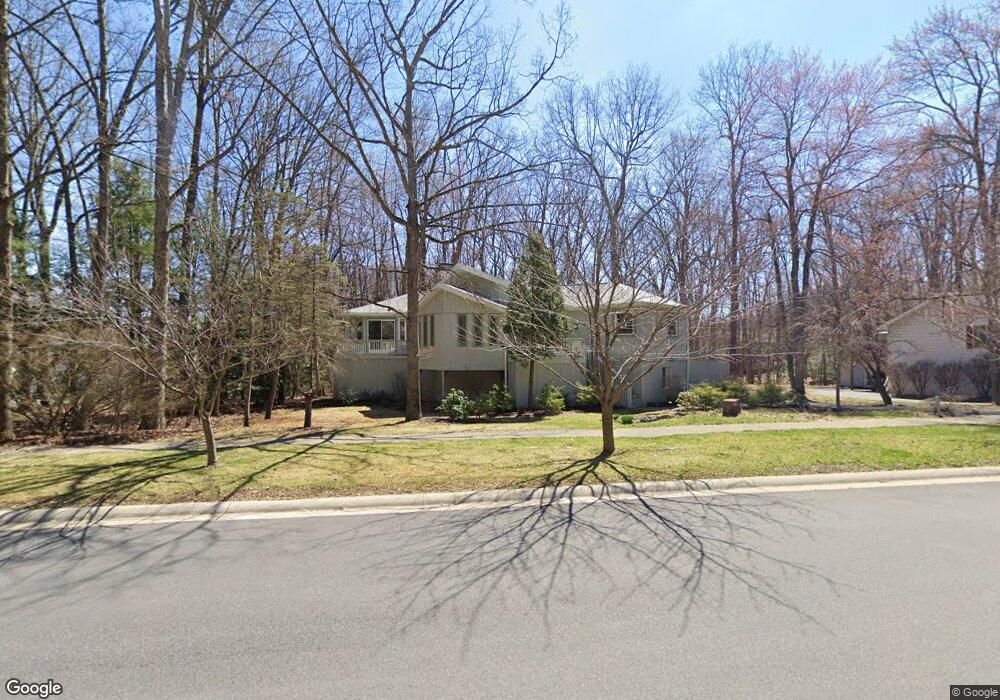
606 Devonshire Dr State College, PA 16803
Patton NeighborhoodEstimated Value: $641,000 - $792,000
5
Beds
4
Baths
4,182
Sq Ft
$171/Sq Ft
Est. Value
About This Home
This home is located at 606 Devonshire Dr, State College, PA 16803 and is currently estimated at $714,600, approximately $170 per square foot. 606 Devonshire Dr is a home located in Centre County with nearby schools including Radio Park Elementary School, Park Forest Middle School, and State College Area High School.
Ownership History
Date
Name
Owned For
Owner Type
Purchase Details
Closed on
May 5, 2006
Sold by
Morgan Helena M
Bought by
Langelaan Jacob W and Ellis Margaret A
Current Estimated Value
Home Financials for this Owner
Home Financials are based on the most recent Mortgage that was taken out on this home.
Original Mortgage
$350,000
Outstanding Balance
$202,705
Interest Rate
6.4%
Mortgage Type
Fannie Mae Freddie Mac
Estimated Equity
$511,895
Purchase Details
Closed on
Jun 13, 2005
Sold by
Coleman Fawn F
Bought by
Morgan Helena M
Home Financials for this Owner
Home Financials are based on the most recent Mortgage that was taken out on this home.
Original Mortgage
$263,900
Interest Rate
5.78%
Mortgage Type
Purchase Money Mortgage
Create a Home Valuation Report for This Property
The Home Valuation Report is an in-depth analysis detailing your home's value as well as a comparison with similar homes in the area
Home Values in the Area
Average Home Value in this Area
Purchase History
| Date | Buyer | Sale Price | Title Company |
|---|---|---|---|
| Langelaan Jacob W | $489,000 | None Available | |
| Morgan Helena M | $215,000 | -- |
Source: Public Records
Mortgage History
| Date | Status | Borrower | Loan Amount |
|---|---|---|---|
| Open | Langelaan Jacob W | $350,000 | |
| Previous Owner | Morgan Helena M | $263,900 |
Source: Public Records
Tax History Compared to Growth
Tax History
| Year | Tax Paid | Tax Assessment Tax Assessment Total Assessment is a certain percentage of the fair market value that is determined by local assessors to be the total taxable value of land and additions on the property. | Land | Improvement |
|---|---|---|---|---|
| 2025 | $8,826 | $126,690 | $17,290 | $109,400 |
| 2024 | $8,234 | $126,690 | $17,290 | $109,400 |
| 2023 | $8,234 | $126,690 | $17,290 | $109,400 |
| 2022 | $8,036 | $126,690 | $17,290 | $109,400 |
| 2021 | $8,036 | $126,690 | $17,290 | $109,400 |
| 2020 | $8,036 | $126,690 | $17,290 | $109,400 |
| 2019 | $5,730 | $126,690 | $17,290 | $109,400 |
| 2018 | $7,790 | $126,690 | $17,290 | $109,400 |
| 2017 | $7,704 | $126,690 | $17,290 | $109,400 |
| 2016 | -- | $126,690 | $17,290 | $109,400 |
| 2015 | -- | $126,690 | $17,290 | $109,400 |
| 2014 | -- | $126,690 | $17,290 | $109,400 |
Source: Public Records
Map
Nearby Homes
- 2251 Red Oak Ln
- 169 Sandy Ridge Rd
- 2292 Oak Leaf Dr
- 291 Oakley Dr
- 1765 Cambridge Dr
- 479 Westgate Dr
- 1635 Princeton Dr
- 1111-C W Aaron Dr
- 835 Galen Dr Unit 835
- 833 Galen Dr
- 1832 Waddle Rd
- 1836 Waddle Rd
- 253 Bolton Ave
- 3182 Carnegie Dr
- 1383 N Allen St
- 1457 Curtin St
- 505 Hillcrest Ave
- 465 Hillcrest Ave
- 936 Taylor St
- 257 Oakwood Ave
- 604 Devonshire Dr
- 610 Devonshire Dr
- 695 Berkshire Dr
- 107 Ridgewood Cir
- 605 Devonshire Dr
- 693 Berkshire Dr
- 105 Ridgewood Cir
- 611 Devonshire Dr
- 106 Ridgewood Cir
- 691 Berkshire Dr
- 603 Devonshire Dr
- 614 Devonshire Dr
- 613 Devonshire Dr
- 101 Cherry Ridge Rd
- 595 Melissa Ln
- 636 Belmont Cir
- 103 Ridgewood Cir
- 596 Melissa Ln
- 689 Berkshire Dr
- 615 Devonshire Dr