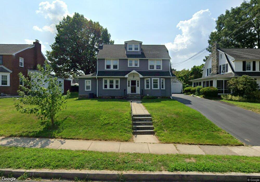
606 Foss Ave Drexel Hill, PA 19026
Estimated Value: $436,000 - $527,000
4
Beds
4
Baths
2,694
Sq Ft
$180/Sq Ft
Est. Value
About This Home
This home is located at 606 Foss Ave, Drexel Hill, PA 19026 and is currently estimated at $483,883, approximately $179 per square foot. 606 Foss Ave is a home located in Delaware County with nearby schools including Hillcrest El School, Drexel Hill Middle School, and Upper Darby High School.
Ownership History
Date
Name
Owned For
Owner Type
Purchase Details
Closed on
Aug 21, 2014
Sold by
Tuinstra Timothy F and Browne Francis P
Bought by
Tuinstra Mary E
Current Estimated Value
Purchase Details
Closed on
Aug 15, 2014
Sold by
Tuinstra Mary E and Tuinstra Timothy F
Bought by
Reichard Greg A and Reichard Mary E
Purchase Details
Closed on
Apr 26, 1994
Sold by
Browne Francis P
Bought by
Browne Francis P
Create a Home Valuation Report for This Property
The Home Valuation Report is an in-depth analysis detailing your home's value as well as a comparison with similar homes in the area
Home Values in the Area
Average Home Value in this Area
Purchase History
| Date | Buyer | Sale Price | Title Company |
|---|---|---|---|
| Tuinstra Mary E | -- | None Available | |
| Reichard Greg A | -- | None Available | |
| Browne Francis P | -- | Commonwealth Land Title Ins |
Source: Public Records
Tax History Compared to Growth
Tax History
| Year | Tax Paid | Tax Assessment Tax Assessment Total Assessment is a certain percentage of the fair market value that is determined by local assessors to be the total taxable value of land and additions on the property. | Land | Improvement |
|---|---|---|---|---|
| 2025 | $11,229 | $265,520 | $44,390 | $221,130 |
| 2024 | $11,229 | $265,520 | $44,390 | $221,130 |
| 2023 | $11,123 | $265,520 | $44,390 | $221,130 |
| 2022 | $10,824 | $265,520 | $44,390 | $221,130 |
| 2021 | $14,595 | $265,520 | $44,390 | $221,130 |
| 2020 | $8,579 | $132,630 | $35,740 | $96,890 |
| 2019 | $8,429 | $132,630 | $35,740 | $96,890 |
| 2018 | $8,332 | $132,630 | $0 | $0 |
| 2017 | $8,115 | $132,630 | $0 | $0 |
| 2016 | $728 | $132,630 | $0 | $0 |
| 2015 | $728 | $132,630 | $0 | $0 |
| 2014 | $728 | $132,630 | $0 | $0 |
Source: Public Records
Map
Nearby Homes
- 719 Mason Ave
- 464 Foss Ave
- 729 Edmonds Ave
- 475 Harper Ave
- 3744 Huey Ave
- 718 Concord Ave
- 3634 Rosemont Ave
- 506 Burmont Rd
- 734 Concord Ave
- 449 Morgan Ave
- 522 Kenwood Rd
- 3804 Rosemont Ave
- 474 Kenwood Rd
- 3708 Garrett Rd
- 3706 Garrett Rd
- 3819-3821 Garrett Rd
- 828 Mason Ave
- 844 Mason Ave
- 2820 Hillcrest Rd
- 455 Irvington Rd