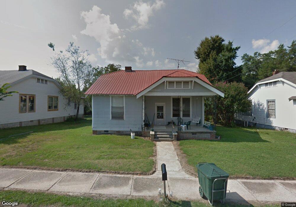
606 Roberts St Elberton, GA 30635
Estimated Value: $64,000 - $138,000
Studio
1
Bath
1,518
Sq Ft
$71/Sq Ft
Est. Value
About This Home
This home is located at 606 Roberts St, Elberton, GA 30635 and is currently estimated at $107,056, approximately $70 per square foot. 606 Roberts St is a home located in Elbert County with nearby schools including Elbert County Primary School, Elbert County Elementary School, and Elbert County Middle School.
Ownership History
Date
Name
Owned For
Owner Type
Purchase Details
Closed on
Jan 12, 2017
Sold by
Rogers Bobbie Sue
Bought by
Andrews Frank D
Current Estimated Value
Purchase Details
Closed on
Apr 27, 2006
Sold by
Burton Gene
Bought by
Rogers Bobbie Sue
Home Financials for this Owner
Home Financials are based on the most recent Mortgage that was taken out on this home.
Original Mortgage
$45,000
Interest Rate
6.33%
Purchase Details
Closed on
Jul 16, 1999
Sold by
Rosser Louise R
Bought by
Burton Gene
Purchase Details
Closed on
Nov 1, 1998
Purchase Details
Closed on
Jan 1, 1960
Create a Home Valuation Report for This Property
The Home Valuation Report is an in-depth analysis detailing your home's value as well as a comparison with similar homes in the area
Home Values in the Area
Average Home Value in this Area
Purchase History
| Date | Buyer | Sale Price | Title Company |
|---|---|---|---|
| Andrews Frank D | $10,000 | -- | |
| Rogers Bobbie Sue | $45,000 | -- | |
| Burton Gene | $23,000 | -- | |
| -- | -- | -- | |
| -- | $1,100 | -- |
Source: Public Records
Mortgage History
| Date | Status | Borrower | Loan Amount |
|---|---|---|---|
| Previous Owner | Rogers Bobbie Sue | $45,000 |
Source: Public Records
Tax History
| Year | Tax Paid | Tax Assessment Tax Assessment Total Assessment is a certain percentage of the fair market value that is determined by local assessors to be the total taxable value of land and additions on the property. | Land | Improvement |
|---|---|---|---|---|
| 2025 | $468 | $19,978 | $3,516 | $16,462 |
| 2024 | $439 | $18,301 | $3,058 | $15,243 |
| 2023 | $439 | $18,300 | $3,058 | $15,243 |
| 2022 | $417 | $17,395 | $3,058 | $14,337 |
| 2021 | $418 | $17,395 | $3,058 | $14,337 |
| 2020 | $362 | $13,335 | $3,058 | $10,277 |
| 2019 | $377 | $13,335 | $3,058 | $10,277 |
| 2018 | $116 | $13,335 | $3,058 | $10,277 |
| 2017 | $267 | $10,505 | $3,058 | $7,447 |
| 2016 | $338 | $13,505 | $3,058 | $10,447 |
| 2015 | -- | $13,505 | $3,058 | $10,447 |
| 2014 | -- | $15,080 | $3,058 | $12,022 |
| 2013 | -- | $16,775 | $3,058 | $13,718 |
Source: Public Records
Map
Nearby Homes
- 201 Snyder Ave
- 349 Cook St
- 430 Knight St
- 0 Old Middleton Rd Unit 10651016
- 1025 Evergreen Dr
- 122 Parkwood Dr
- 135 Brookside Dr
- 416 E Gordon St
- 214 Campbell St
- 334 Heard St
- 181 Brookside Dr
- 1066 Oglesby Boulevard Extension
- 151 S Tusten St
- 120 S Tusten St
- 253 Edwards St
- 252 Edwards St
- 141 Wildwood Dr
- 139 Myrtle St
- 222 E Church St
- 105 S Thomas St
Your Personal Tour Guide
Ask me questions while you tour the home.