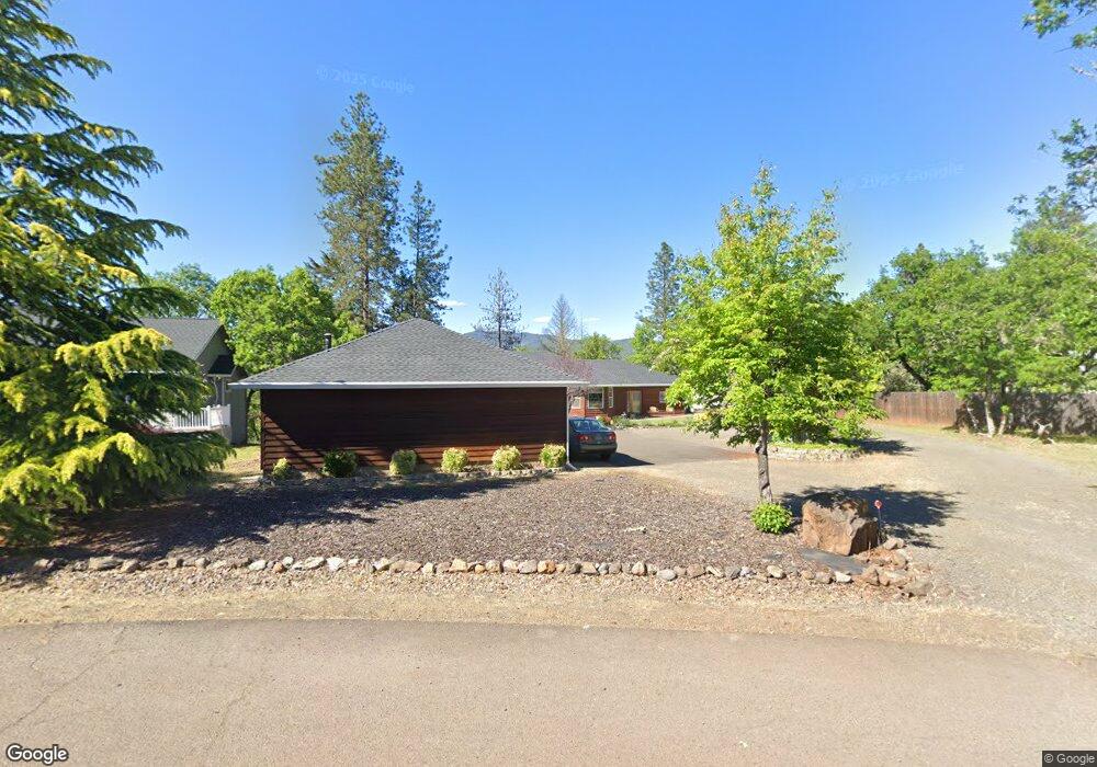
606 Sarma Dr Shady Cove, OR 97539
Estimated Value: $454,000 - $509,770
3
Beds
2
Baths
2,065
Sq Ft
$233/Sq Ft
Est. Value
About This Home
This home is located at 606 Sarma Dr, Shady Cove, OR 97539 and is currently estimated at $480,443, approximately $232 per square foot. 606 Sarma Dr is a home located in Jackson County with nearby schools including Shady Cove School, Eagle Point Middle School, and White Mountain Middle School.
Ownership History
Date
Name
Owned For
Owner Type
Purchase Details
Closed on
Mar 6, 2008
Sold by
Brown Kenneth M and Brown Susan
Bought by
Brown Kenneth M and Brown Susan L
Current Estimated Value
Purchase Details
Closed on
Jan 15, 2007
Sold by
Brainard Benjamin S and Brainard Kelly J
Bought by
Brown Kenneth M and Brown Susan
Purchase Details
Closed on
Dec 17, 2002
Sold by
Mcnall Charles R
Bought by
Brainard Benjamin S and Brainard Kelly J
Home Financials for this Owner
Home Financials are based on the most recent Mortgage that was taken out on this home.
Original Mortgage
$172,000
Interest Rate
3%
Purchase Details
Closed on
Sep 25, 1998
Sold by
Weaver Douglas L and Weaver Shannon
Bought by
Mcnall Charles R
Home Financials for this Owner
Home Financials are based on the most recent Mortgage that was taken out on this home.
Original Mortgage
$97,500
Interest Rate
6.88%
Create a Home Valuation Report for This Property
The Home Valuation Report is an in-depth analysis detailing your home's value as well as a comparison with similar homes in the area
Home Values in the Area
Average Home Value in this Area
Purchase History
| Date | Buyer | Sale Price | Title Company |
|---|---|---|---|
| Brown Kenneth M | -- | None Available | |
| Brown Kenneth M | $360,000 | Amerititle | |
| Brainard Benjamin S | $215,000 | Lawyers Title Insurance Corp | |
| Mcnall Charles R | $150,000 | Jackson County Title |
Source: Public Records
Mortgage History
| Date | Status | Borrower | Loan Amount |
|---|---|---|---|
| Previous Owner | Brainard Benjamin S | $172,000 | |
| Previous Owner | Mcnall Charles R | $97,500 |
Source: Public Records
Tax History Compared to Growth
Tax History
| Year | Tax Paid | Tax Assessment Tax Assessment Total Assessment is a certain percentage of the fair market value that is determined by local assessors to be the total taxable value of land and additions on the property. | Land | Improvement |
|---|---|---|---|---|
| 2025 | $3,422 | $286,340 | $83,880 | $202,460 |
| 2024 | $3,422 | $278,000 | $81,440 | $196,560 |
| 2023 | $3,306 | $269,910 | $79,060 | $190,850 |
| 2022 | $3,218 | $269,910 | $79,060 | $190,850 |
| 2021 | $3,125 | $262,050 | $76,760 | $185,290 |
| 2020 | $3,362 | $254,420 | $74,520 | $179,900 |
| 2019 | $3,319 | $239,820 | $70,250 | $169,570 |
| 2018 | $3,301 | $232,840 | $68,200 | $164,640 |
| 2017 | $3,021 | $232,840 | $68,200 | $164,640 |
| 2016 | $2,913 | $219,480 | $64,290 | $155,190 |
| 2015 | $2,743 | $213,130 | $78,590 | $134,540 |
| 2014 | $2,735 | $206,890 | $60,590 | $146,300 |
Source: Public Records
Map
Nearby Homes
- 640 Sarma Dr
- 635 Sarma Dr
- 23159 Highway 62
- 124 Hudspeth Ln
- 110 Cora Dr
- 0 Pinetop Terrace Unit 220161538
- 1027 Chevney Way
- 30 Dion Ct Unit 3
- 62 Erickson Ave Unit A-B
- 1755 Old Ferry Rd
- 551 Hudspeth Ln
- 23619 Oregon 62
- 838 Ragsdale Rd
- 778 Ragsdale Rd
- 580 Ragsdale Rd
- 84 Meadow Ln
- 975 Old Ferry Rd
- 234 Williams Ln
- 22071 Highway 62 Unit 54
- 202 White Oak Way