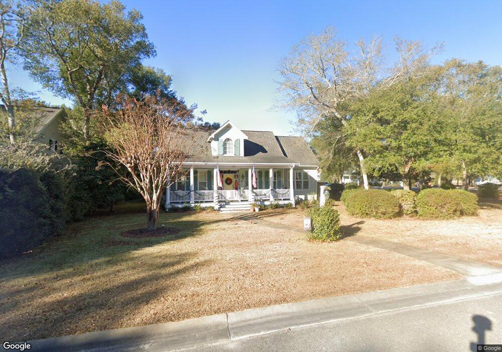
6063 Sullivan Ridge Rd Southport, NC 28461
Estimated Value: $722,270 - $857,000
3
Beds
3
Baths
2,565
Sq Ft
$316/Sq Ft
Est. Value
About This Home
This home is located at 6063 Sullivan Ridge Rd, Southport, NC 28461 and is currently estimated at $811,318, approximately $316 per square foot. 6063 Sullivan Ridge Rd is a home located in Brunswick County with nearby schools including Southport Elementary School, South Brunswick Middle School, and South Brunswick High School.
Ownership History
Date
Name
Owned For
Owner Type
Purchase Details
Closed on
Aug 27, 2013
Sold by
Donnell Thomas F O and Donnell Carol A O
Bought by
Snyder Richard J and Snyder Gale S
Current Estimated Value
Home Financials for this Owner
Home Financials are based on the most recent Mortgage that was taken out on this home.
Original Mortgage
$235,000
Outstanding Balance
$175,918
Interest Rate
4.48%
Mortgage Type
New Conventional
Estimated Equity
$635,400
Purchase Details
Closed on
Mar 16, 2011
Sold by
Odonnell Carol A and Odonnell Thomas F
Bought by
Odonnell Carol A and Odonnell Thomas F
Create a Home Valuation Report for This Property
The Home Valuation Report is an in-depth analysis detailing your home's value as well as a comparison with similar homes in the area
Home Values in the Area
Average Home Value in this Area
Purchase History
| Date | Buyer | Sale Price | Title Company |
|---|---|---|---|
| Snyder Richard J | $360,000 | None Available | |
| Odonnell Carol A | -- | Performance Title |
Source: Public Records
Mortgage History
| Date | Status | Borrower | Loan Amount |
|---|---|---|---|
| Open | Snyder Richard J | $235,000 |
Source: Public Records
Tax History Compared to Growth
Tax History
| Year | Tax Paid | Tax Assessment Tax Assessment Total Assessment is a certain percentage of the fair market value that is determined by local assessors to be the total taxable value of land and additions on the property. | Land | Improvement |
|---|---|---|---|---|
| 2025 | $4,335 | $568,640 | $100,000 | $468,640 |
| 2024 | $4,335 | $568,640 | $100,000 | $468,640 |
| 2023 | $4,359 | $568,640 | $100,000 | $468,640 |
| 2022 | $4,359 | $430,040 | $60,000 | $370,040 |
| 2021 | $3,804 | $430,040 | $60,000 | $370,040 |
| 2020 | $3,804 | $430,040 | $60,000 | $370,040 |
| 2019 | $3,804 | $62,420 | $60,000 | $2,420 |
| 2018 | $3,554 | $74,410 | $71,500 | $2,910 |
| 2017 | $3,529 | $74,410 | $71,500 | $2,910 |
| 2016 | $3,279 | $74,410 | $71,500 | $2,910 |
| 2015 | $3,279 | $399,550 | $71,500 | $328,050 |
| 2014 | $2,473 | $312,149 | $110,000 | $202,149 |
Source: Public Records
Map
Nearby Homes
- 5122 Prices Creek Dr
- 5138 Fernwood Dr
- 1.12 Ac Jabbertown Rd
- 5122 Fernwood Dr
- 5147 Fernwood Dr
- 136 Park Ave
- 305 Fire Fly SE
- 5975 Gray Squirrel Path
- 301 Fire Fly Ln
- 202 Fire Fly Ln
- 411 Fire Fly Ln
- 308 Fire Fly Ln
- 5988 Gray Squirrel Path
- 492 Jabbertown Rd
- 2035 Oakton Dr Unit 9
- 131 Stuart Ave Unit 42
- 131 Stuart Ave
- 2079 Rosin Dr
- 2079 Rosin Dr Unit 17
- 1014 Softwind Way
- 6063 Sullivans Ridge Rd
- 6064 Sullivans Ridge
- 6062 Sullivan Ridge Rd
- 100 Sullivan Ridge Rd
- 0 Sullivan Ridge Rd
- 6090 Sullivan Ridge Rd
- 6070 Sullivan Ridge Rd
- 6099 Sullivan Ridge Rd
- Lot 98 Sullivan Ridge Rd
- 6060 Sullivan Ridge Rd
- 6068 Sullivans Ridge
- L-100 Sullivans Ridge
- 5126 Prices Creek Dr
- 5128 Prices Creek Dr
- 5130 Prices Creek Dr
- 6096 Sullivan Ridge Rd
- 6094 Sullivan Ridge Rd
- 5127 Prices Creek Dr
- 0 Sullivans Ridge Unit 20634486
- 0 Sullivans Ridge Unit 20651979