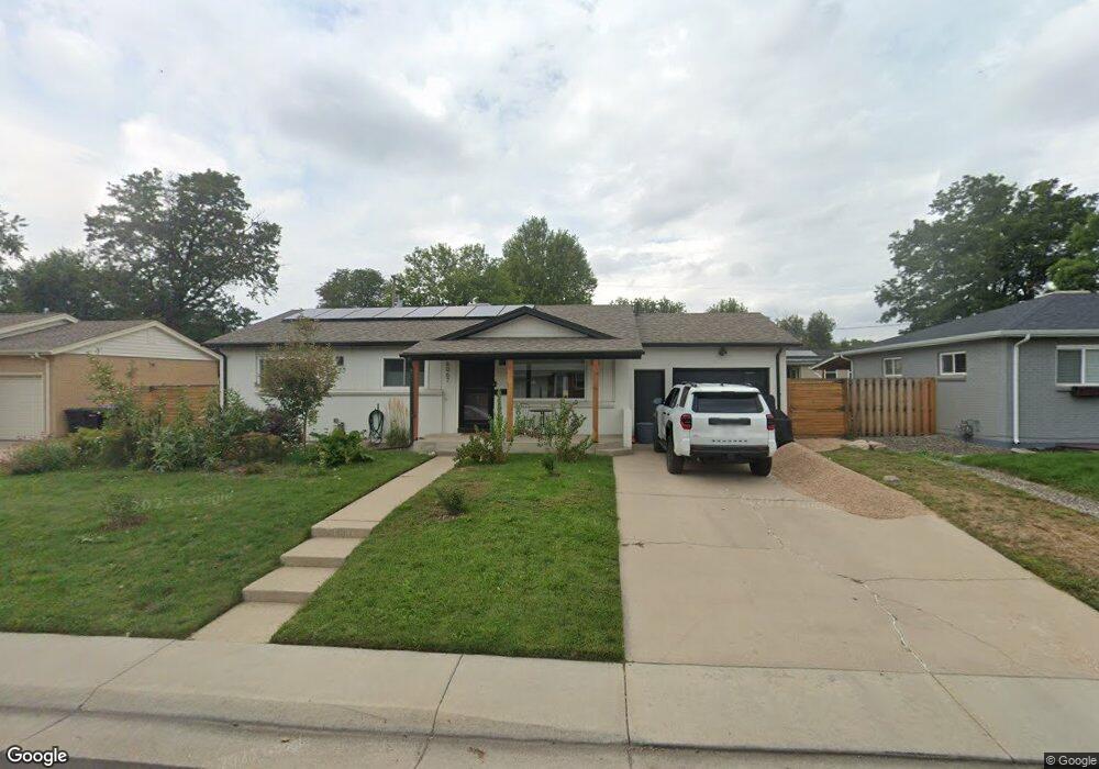
6067 Independence St Arvada, CO 80004
Alta Vista NeighborhoodEstimated Value: $572,000 - $620,805
4
Beds
3
Baths
2,515
Sq Ft
$238/Sq Ft
Est. Value
About This Home
This home is located at 6067 Independence St, Arvada, CO 80004 and is currently estimated at $597,451, approximately $237 per square foot. 6067 Independence St is a home located in Jefferson County with nearby schools including Lawrence Elementary School, North Arvada Middle School, and Arvada High School.
Ownership History
Date
Name
Owned For
Owner Type
Purchase Details
Closed on
Sep 13, 2021
Sold by
Bragg Jesse S and Bragg Audrey A
Bought by
Clark Brandon Jeffrey and Clark Lorena Kathryn
Current Estimated Value
Home Financials for this Owner
Home Financials are based on the most recent Mortgage that was taken out on this home.
Original Mortgage
$551,000
Outstanding Balance
$500,621
Interest Rate
2.7%
Mortgage Type
New Conventional
Estimated Equity
$96,830
Purchase Details
Closed on
Jan 4, 2019
Sold by
Parish Dural L and Estate Of Dural L Parish Jr
Bought by
Bragg Jesse S and Bragg Audrey A S
Home Financials for this Owner
Home Financials are based on the most recent Mortgage that was taken out on this home.
Original Mortgage
$346,478
Interest Rate
4.7%
Mortgage Type
New Conventional
Create a Home Valuation Report for This Property
The Home Valuation Report is an in-depth analysis detailing your home's value as well as a comparison with similar homes in the area
Home Values in the Area
Average Home Value in this Area
Purchase History
| Date | Buyer | Sale Price | Title Company |
|---|---|---|---|
| Clark Brandon Jeffrey | $601,000 | Land Title Guarantee Company | |
| Bragg Jesse S | $357,194 | None Available |
Source: Public Records
Mortgage History
| Date | Status | Borrower | Loan Amount |
|---|---|---|---|
| Open | Clark Brandon Jeffrey | $551,000 | |
| Previous Owner | Bragg Jesse S | $346,478 |
Source: Public Records
Tax History
| Year | Tax Paid | Tax Assessment Tax Assessment Total Assessment is a certain percentage of the fair market value that is determined by local assessors to be the total taxable value of land and additions on the property. | Land | Improvement |
|---|---|---|---|---|
| 2024 | $3,651 | $37,638 | $16,506 | $21,132 |
| 2023 | $3,651 | $37,638 | $16,506 | $21,132 |
| 2022 | $2,777 | $28,359 | $12,214 | $16,145 |
| 2021 | $2,823 | $29,174 | $12,565 | $16,609 |
| 2020 | $2,420 | $25,080 | $9,788 | $15,292 |
| 2019 | $2,388 | $25,080 | $9,788 | $15,292 |
| 2018 | $2,241 | $22,887 | $6,555 | $16,332 |
| 2017 | $1,406 | $22,887 | $6,555 | $16,332 |
| 2016 | $981 | $18,267 | $5,539 | $12,728 |
| 2015 | $755 | $18,267 | $5,539 | $12,728 |
| 2014 | $755 | $14,910 | $4,872 | $10,038 |
Source: Public Records
Map
Nearby Homes
- 6141 Hoyt St
- 6025 Brooks Dr
- 9487 W 58th Ave Unit B
- 9487 W 58th Ave Unit A
- 9457 W 58th Ave Unit B
- 5890 Holland Ct Unit B
- 9546 W 58th Ave Unit B
- 6209 Brooks Dr
- 6077 Flower St
- 5937 Flower St
- 6069 Lee St
- 9142 Oberon Rd
- 8940 Cole Dr
- 10322 W 59th Ave Unit 1
- 6371 Brooks Dr
- 6376 Brooks Dr
- 9539 Grandview Ave
- 9015 W 63rd Ave
- 6240 Everett Ct Unit B
- 8520 W 59th Ave
- 6057 Independence St
- 6077 Independence St
- 6074 Iris Way
- 6084 Iris Way
- 6087 Independence St
- 6047 Independence St
- 6120 Independence St
- 6130 Independence St
- 6094 Iris Way
- 6100 Independence St
- 6052 Iris Way
- 6140 Independence St
- 6037 Independence St
- 6092 Independence St
- 6048 Iris Way
- 6150 Independence St
- 6079 Iris Way
- 6089 Iris Way
- 6107 Independence St
- 6072 Independence St
Your Personal Tour Guide
Ask me questions while you tour the home.