Estimated Value: $127,000 - $177,000
Studio
--
Bath
1,056
Sq Ft
$149/Sq Ft
Est. Value
About This Home
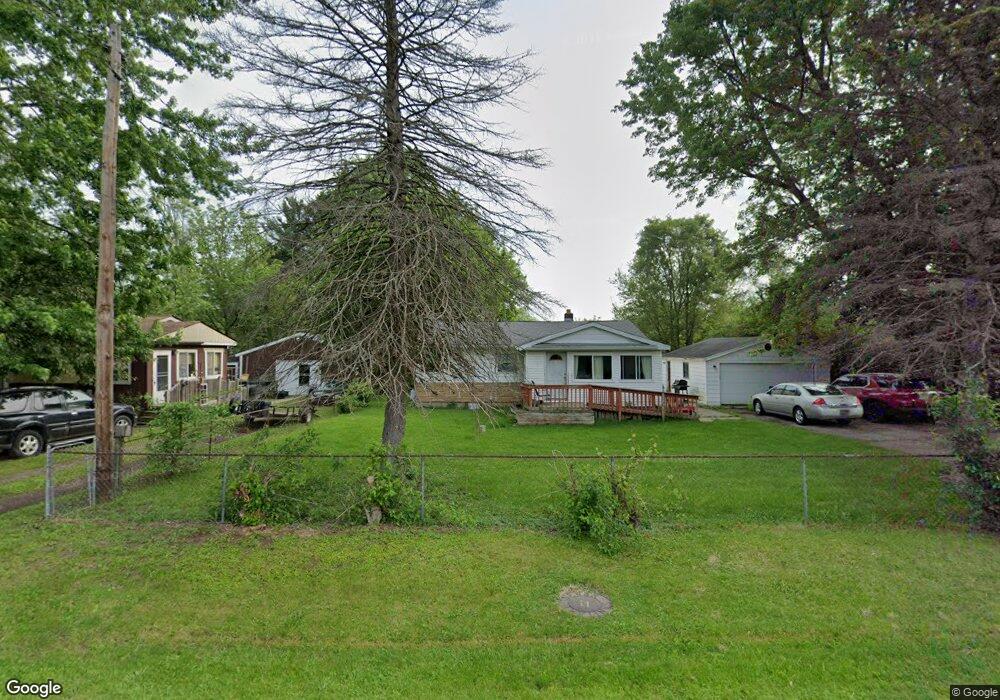
This home is located at 6069 Crown Point, Flint, MI 48506 and is currently estimated at $157,016, approximately $148 per square foot. 6069 Crown Point is a home located in Genesee County with nearby schools including Weston Elementary School, Leota Fiedler Elementary School, and Kate Dowdall Elementary School.
Ownership History
Date
Name
Owned For
Owner Type
Purchase Details
Closed on
May 21, 2007
Sold by
Royce Robert D and Royce Deborah J
Bought by
Timm Stephen F and Timm Leslie M
Current Estimated Value
Purchase Details
Closed on
May 25, 2006
Sold by
Royce Robert D
Bought by
Royce Robert D and Hunt Ruth A
Create a Home Valuation Report for This Property
The Home Valuation Report is an in-depth analysis detailing your home's value as well as a comparison with similar homes in the area
Home Values in the Area
Average Home Value in this Area
Purchase History
| Date | Buyer | Sale Price | Title Company |
|---|---|---|---|
| Timm Stephen F | $79,997 | Sargents Title Company | |
| Royce Robert D | -- | None Available |
Source: Public Records
Tax History
| Year | Tax Paid | Tax Assessment Tax Assessment Total Assessment is a certain percentage of the fair market value that is determined by local assessors to be the total taxable value of land and additions on the property. | Land | Improvement |
|---|---|---|---|---|
| 2025 | $1,722 | $67,300 | $0 | $0 |
| 2024 | $367 | $61,800 | $0 | $0 |
| 2023 | $350 | $55,300 | $0 | $0 |
| 2022 | $1,185 | $51,900 | $0 | $0 |
| 2021 | $1,176 | $47,000 | $0 | $0 |
| 2020 | $321 | $42,900 | $0 | $0 |
| 2019 | $315 | $37,800 | $0 | $0 |
| 2018 | $1,235 | $34,700 | $0 | $0 |
| 2017 | $1,080 | $33,400 | $0 | $0 |
| 2016 | $1,555 | $32,200 | $0 | $0 |
| 2015 | $872 | $30,400 | $0 | $0 |
| 2014 | $291 | $27,300 | $0 | $0 |
| 2012 | -- | $24,300 | $24,300 | $0 |
Source: Public Records
Map
Nearby Homes
- 4062 N Belsay Rd
- 6054 E Pierson Rd
- 6161 Finch Ln
- 3365 Eastdale Dr
- 6443 Richfield Rd
- 6363 Bluejay Dr
- 3296 Mills Acres St
- 3485 N Vassar Rd
- 3179 Gehring Dr
- 3267 Mills Acres St
- 3148 Gehring Dr
- 5067 Paro Dr
- 4413 Esta Dr
- 4455 N Genesee Rd
- 4435 Meadowbrook Dr
- 4452 Muriel Dr
- 0 Sugar Maple Farms Unit 50195365
- 0 Whisper Ridge Ct
- 4489 Home Town Dr Unit 32
- 3413 Blue Lake Dr
- 6061 Crown Point
- 6055 Crown Point
- 6087 Crown Point
- 6076 Stoney Point St
- 6088 Stoney Point St
- 6087 Crown Point St
- 6082 Stoney Point St
- 6068 Stoney Point St
- 6080 Crown Point St
- 6072 Crown Point
- 6062 Crown Point
- 6080 Crown Point
- 6060 Stoney Point St
- 6056 Crown Point
- 6052 Stoney Point St
- 4099 Independence Dr
- 6088 Crown Point Unit Bldg-Unit
- 6088 Crown Point
- 4091 Independence Dr
- 4109 Independence Dr
Your Personal Tour Guide
Ask me questions while you tour the home.