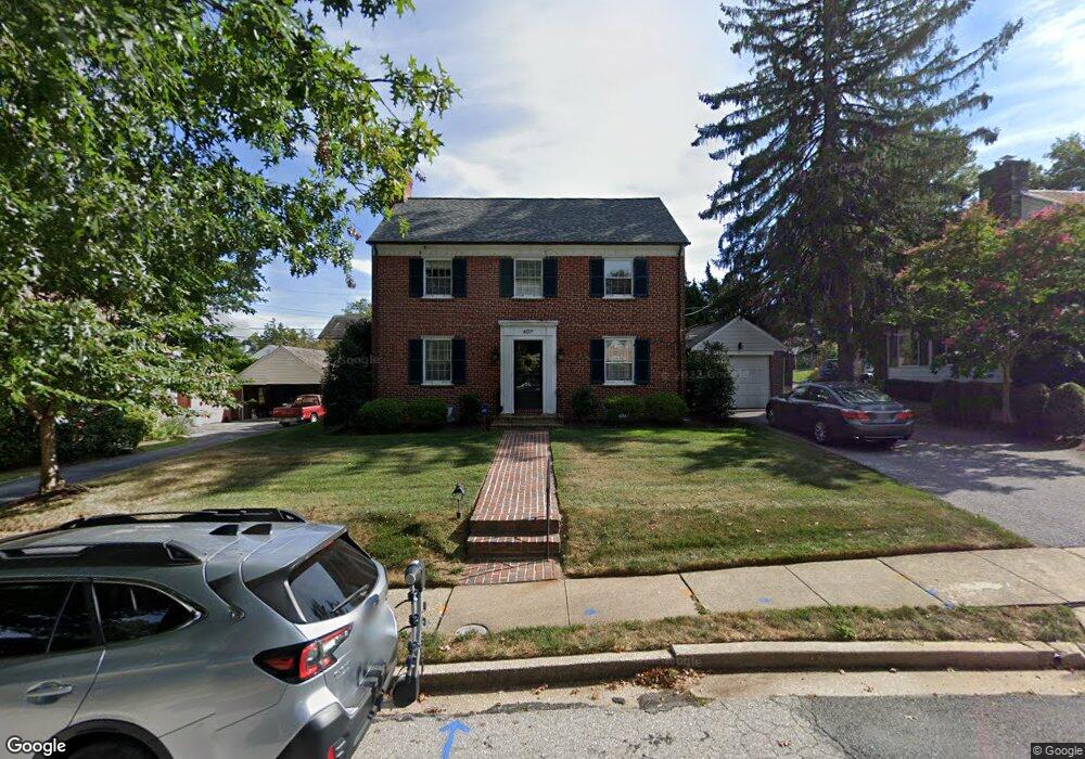
607 Coventry Rd Towson, MD 21286
Estimated Value: $739,525 - $766,000
3
Beds
2
Baths
2,368
Sq Ft
$320/Sq Ft
Est. Value
About This Home
This home is located at 607 Coventry Rd, Towson, MD 21286 and is currently estimated at $756,881, approximately $319 per square foot. 607 Coventry Rd is a home located in Baltimore County with nearby schools including Stoneleigh Elementary School, Dumbarton Middle School, and Towson High Law & Public Policy.
Ownership History
Date
Name
Owned For
Owner Type
Purchase Details
Closed on
Oct 5, 2010
Sold by
Helldorfer John A
Bought by
Pulcinella Michael J and Pulcinella Abigail R
Current Estimated Value
Home Financials for this Owner
Home Financials are based on the most recent Mortgage that was taken out on this home.
Original Mortgage
$375,000
Outstanding Balance
$247,586
Interest Rate
4.36%
Mortgage Type
New Conventional
Estimated Equity
$509,295
Purchase Details
Closed on
Jul 14, 1971
Sold by
Busky John F
Bought by
Helldorfer John A
Create a Home Valuation Report for This Property
The Home Valuation Report is an in-depth analysis detailing your home's value as well as a comparison with similar homes in the area
Home Values in the Area
Average Home Value in this Area
Purchase History
| Date | Buyer | Sale Price | Title Company |
|---|---|---|---|
| Pulcinella Michael J | $495,000 | -- | |
| Helldorfer John A | $37,000 | -- |
Source: Public Records
Mortgage History
| Date | Status | Borrower | Loan Amount |
|---|---|---|---|
| Open | Pulcinella Michael J | $375,000 |
Source: Public Records
Tax History
| Year | Tax Paid | Tax Assessment Tax Assessment Total Assessment is a certain percentage of the fair market value that is determined by local assessors to be the total taxable value of land and additions on the property. | Land | Improvement |
|---|---|---|---|---|
| 2025 | $6,930 | $583,600 | $138,600 | $445,000 |
| 2024 | $6,930 | $554,233 | $0 | $0 |
| 2023 | $3,318 | $524,867 | $0 | $0 |
| 2022 | $5,071 | $495,500 | $129,700 | $365,800 |
| 2021 | $5,867 | $483,800 | $0 | $0 |
| 2020 | $5,867 | $472,100 | $0 | $0 |
| 2019 | $5,619 | $460,400 | $129,700 | $330,700 |
| 2018 | $5,409 | $423,433 | $0 | $0 |
| 2017 | $5,071 | $386,467 | $0 | $0 |
| 2016 | $4,932 | $349,500 | $0 | $0 |
| 2015 | $4,932 | $349,500 | $0 | $0 |
| 2014 | $4,932 | $349,500 | $0 | $0 |
Source: Public Records
Map
Nearby Homes
- 517 Worcester Rd
- 609 Stevenson Ln
- 310 Worthington Rd
- 7404 Knollwood Rd
- 150 Marburth Ave
- 31 Meridian Ln
- 212 E Burke Ave
- 224 E Burke Ave
- 202 Wilden Dr
- 1000 Stevenson Ln
- 6923 Summit Cir
- 664 Regester Ave
- 345 Eudowood Ln
- 305 Davage Ln
- 220 E Pennsylvania Ave
- 806 Forest Rd
- 205 E Joppa Rd
- 205 E Joppa Rd
- 205 E Joppa Rd
- 205 E Joppa Rd
- 609 Coventry Rd
- 611 Coventry Rd
- 603 Coventry Rd
- 605 Coventry Rd
- 612 Worcester Rd
- 610 Worcester Rd
- 602 Coventry Rd
- 604 Coventry Rd
- 600 Coventry Rd
- 606 Coventry Rd
- 615 Coventry Rd
- 606 Worcester Rd
- 13 Aintree Rd
- 11 Aintree Rd
- 601 Coventry Rd
- 608 Coventry Rd
- 609 Worcester Rd
- 607 Worcester Rd
- 17 Aintree Rd
- 604 Worcester Rd
Your Personal Tour Guide
Ask me questions while you tour the home.