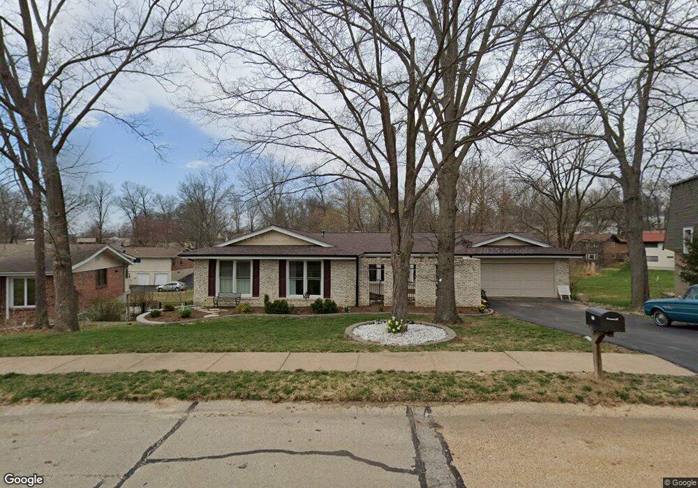
607 Forrester Dr Ballwin, MO 63011
Estimated Value: $427,000 - $457,410
3
Beds
3
Baths
1,998
Sq Ft
$222/Sq Ft
Est. Value
About This Home
This home is located at 607 Forrester Dr, Ballwin, MO 63011 and is currently estimated at $443,603, approximately $222 per square foot. 607 Forrester Dr is a home located in St. Louis County with nearby schools including Pierremont Elementary School, Parkway West Middle School, and Parkway West High School.
Ownership History
Date
Name
Owned For
Owner Type
Purchase Details
Closed on
Jul 8, 1998
Sold by
Eng John T and Eng Cynthia B
Bought by
Waddell Thomas M and Waddell Joyce C
Current Estimated Value
Home Financials for this Owner
Home Financials are based on the most recent Mortgage that was taken out on this home.
Original Mortgage
$139,000
Outstanding Balance
$28,668
Interest Rate
7.09%
Estimated Equity
$414,935
Create a Home Valuation Report for This Property
The Home Valuation Report is an in-depth analysis detailing your home's value as well as a comparison with similar homes in the area
Home Values in the Area
Average Home Value in this Area
Purchase History
| Date | Buyer | Sale Price | Title Company |
|---|---|---|---|
| Waddell Thomas M | -- | -- |
Source: Public Records
Mortgage History
| Date | Status | Borrower | Loan Amount |
|---|---|---|---|
| Open | Waddell Thomas M | $139,000 |
Source: Public Records
Tax History
| Year | Tax Paid | Tax Assessment Tax Assessment Total Assessment is a certain percentage of the fair market value that is determined by local assessors to be the total taxable value of land and additions on the property. | Land | Improvement |
|---|---|---|---|---|
| 2025 | $5,325 | $83,450 | $29,470 | $53,980 |
| 2024 | $5,325 | $77,970 | $17,420 | $60,550 |
| 2023 | $5,371 | $77,970 | $17,420 | $60,550 |
| 2022 | $4,840 | $64,540 | $19,340 | $45,200 |
| 2021 | $4,812 | $64,540 | $19,340 | $45,200 |
| 2020 | $4,238 | $54,340 | $19,170 | $35,170 |
| 2019 | $4,168 | $54,340 | $19,170 | $35,170 |
| 2018 | $3,972 | $48,030 | $17,270 | $30,760 |
| 2017 | $3,806 | $48,030 | $17,270 | $30,760 |
| 2016 | $3,703 | $43,430 | $12,520 | $30,910 |
Source: Public Records
Map
Nearby Homes
- 404 Spring Meadows Dr
- 490 Maymont Dr
- 174 Baxter Heights Ct Unit 18
- 618 Shady Meadows Dr
- 217 Creve Coeur Ave
- 304 Shady Meadows Dr
- 1041 Kennedy Ln
- 1061 Summer Tree Dr
- 108 Maple Ln
- 828 Windmill Dr
- 619 Marcel Dr
- 212 Lindy Blvd
- 0 Unknown Unit MIS25060078
- 0 Unknown Unit MIS25060104
- 0 Unknown Unit MIS25060076
- 0 Unknown Unit MIS25060105
- 0 Unknown Unit MIS25060100
- 0 Unknown Unit MIS25060079
- 0 Unknown Unit MIS25060108
- 0 Unknown Unit MIS25060103
- 609 Forrester Dr
- 605 Forrester Dr
- 18 Leaside Ct
- 17 Leaside Ct
- 602 Forrester Dr
- 19 Leaside Ct
- 611 Forrester Dr
- 603 Forrester Dr
- 22 Leaside Ct
- 604 Forrester Dr
- 21 Leaside Ct
- 23 Leaside Ct
- 600 Forrester Dr
- 428 Glan Tai Dr
- 20 Leaside Ct
- 16 Leaside Ct
- 432 Glan Tai Dr
- 606 Forrester Dr
- 430 Glan Tai Dr
- 24 Leaside Ct
Your Personal Tour Guide
Ask me questions while you tour the home.