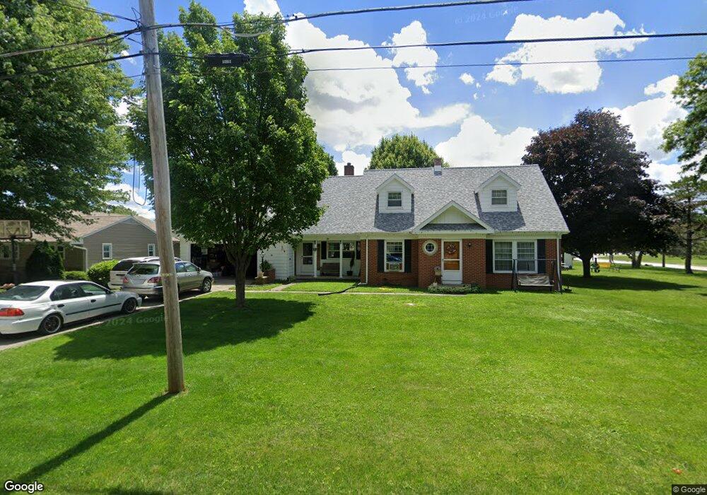
607 Hart Ave Fostoria, OH 44830
Estimated Value: $159,000 - $231,000
4
Beds
2
Baths
1,833
Sq Ft
$103/Sq Ft
Est. Value
About This Home
This home is located at 607 Hart Ave, Fostoria, OH 44830 and is currently estimated at $189,566, approximately $103 per square foot. 607 Hart Ave is a home located in Wood County with nearby schools including Fostoria Intermediate Elementary School and Fostoria Junior/Senior High School.
Ownership History
Date
Name
Owned For
Owner Type
Purchase Details
Closed on
Jul 15, 2021
Sold by
Ritter Lonnie L and Ritter Jennifer J
Bought by
Ritter Jennifer J
Current Estimated Value
Purchase Details
Closed on
Mar 17, 2009
Sold by
Warner Rita M
Bought by
Ritter Lonnie L and Ritter Jennifer J
Home Financials for this Owner
Home Financials are based on the most recent Mortgage that was taken out on this home.
Original Mortgage
$90,000
Interest Rate
5.2%
Mortgage Type
VA
Purchase Details
Closed on
Feb 23, 2006
Sold by
Estate Of Robert L Warner
Bought by
Warner Rita M
Purchase Details
Closed on
Jan 1, 1990
Bought by
Warner Robert L
Create a Home Valuation Report for This Property
The Home Valuation Report is an in-depth analysis detailing your home's value as well as a comparison with similar homes in the area
Home Values in the Area
Average Home Value in this Area
Purchase History
| Date | Buyer | Sale Price | Title Company |
|---|---|---|---|
| Ritter Jennifer J | -- | Guernsey Law Office Llc | |
| Ritter Lonnie L | $100,000 | Attorney | |
| Warner Rita M | -- | None Available | |
| Warner Robert L | -- | -- |
Source: Public Records
Mortgage History
| Date | Status | Borrower | Loan Amount |
|---|---|---|---|
| Previous Owner | Ritter Lonnie L | $90,000 |
Source: Public Records
Tax History Compared to Growth
Tax History
| Year | Tax Paid | Tax Assessment Tax Assessment Total Assessment is a certain percentage of the fair market value that is determined by local assessors to be the total taxable value of land and additions on the property. | Land | Improvement |
|---|---|---|---|---|
| 2024 | $2,309 | $43,820 | $3,535 | $40,285 |
| 2023 | $2,309 | $43,830 | $3,540 | $40,290 |
| 2021 | $2,199 | $35,990 | $2,980 | $33,010 |
| 2020 | $2,221 | $35,990 | $2,980 | $33,010 |
| 2019 | $1,885 | $29,970 | $2,980 | $26,990 |
| 2018 | $1,914 | $29,970 | $2,980 | $26,990 |
| 2017 | $1,887 | $29,970 | $2,980 | $26,990 |
| 2016 | $1,616 | $28,850 | $2,840 | $26,010 |
| 2015 | $1,616 | $28,850 | $2,840 | $26,010 |
| 2014 | $1,668 | $28,850 | $2,840 | $26,010 |
| 2013 | $1,893 | $30,350 | $2,980 | $27,370 |
Source: Public Records
Map
Nearby Homes
- 901 Central Ave
- 727 Eisenhower Dr
- 603 N Vine St
- 892 N Countyline St
- 900 N Countyline St
- 931 N Union St
- 723 N Union St
- 375 Thomas St
- 207 W Culbertson St
- 1324 N Union St
- 520 N Union St
- 509 College Ave
- 633 Maple St
- 203 N Union St
- 425 W Ridge Dr Unit U5
- 634 W Tiffin St
- 411 Monticello Dr
- 1401 Van Buren St Unit U24
- 540 N Poplar St
- 220 E High St