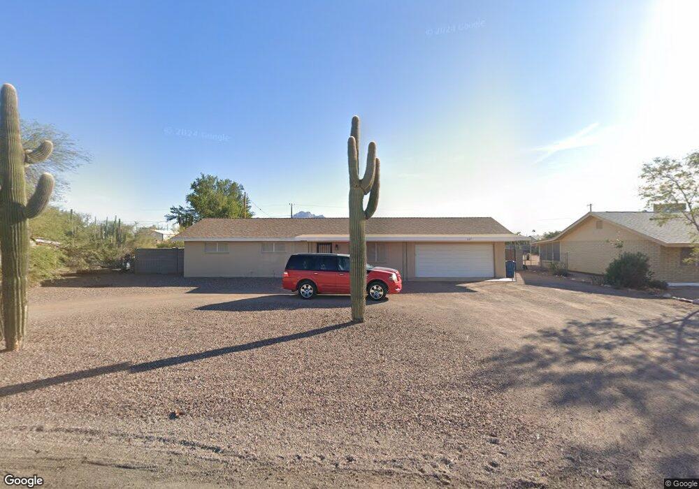
607 N Thunderbird Dr Apache Junction, AZ 85120
Estimated Value: $365,768 - $407,000
3
Beds
2
Baths
1,344
Sq Ft
$287/Sq Ft
Est. Value
About This Home
This home is located at 607 N Thunderbird Dr, Apache Junction, AZ 85120 and is currently estimated at $386,192, approximately $287 per square foot. 607 N Thunderbird Dr is a home located in Pinal County with nearby schools including Four Peaks Elementary School, Cactus Canyon Junior High School, and Apache Junction High School.
Ownership History
Date
Name
Owned For
Owner Type
Purchase Details
Closed on
Oct 15, 2021
Sold by
Cummer Michael F and Cummer Mya T
Bought by
Cummer Michael F and Michael F Cummer Trust
Current Estimated Value
Home Financials for this Owner
Home Financials are based on the most recent Mortgage that was taken out on this home.
Original Mortgage
$185,000
Outstanding Balance
$168,703
Interest Rate
2.8%
Mortgage Type
New Conventional
Estimated Equity
$217,489
Purchase Details
Closed on
Oct 12, 2021
Sold by
Michael F Cummer Trust and Mihcael F Cummer Trust
Bought by
Cummer Michael F and Cummer Mya T
Home Financials for this Owner
Home Financials are based on the most recent Mortgage that was taken out on this home.
Original Mortgage
$185,000
Outstanding Balance
$168,703
Interest Rate
2.8%
Mortgage Type
New Conventional
Estimated Equity
$217,489
Purchase Details
Closed on
Feb 27, 2012
Sold by
Cummer Michael F
Bought by
Cummer Michael F
Home Financials for this Owner
Home Financials are based on the most recent Mortgage that was taken out on this home.
Original Mortgage
$122,270
Interest Rate
3.92%
Mortgage Type
New Conventional
Purchase Details
Closed on
Jun 13, 2008
Sold by
Cummer Michael F
Bought by
Cummer Michael F
Purchase Details
Closed on
Dec 10, 2004
Sold by
Saxton Tracy
Bought by
Stewart Jeffrey T and Stewart Elizabeth C
Home Financials for this Owner
Home Financials are based on the most recent Mortgage that was taken out on this home.
Original Mortgage
$148,000
Interest Rate
5.8%
Mortgage Type
Unknown
Purchase Details
Closed on
Oct 7, 2004
Sold by
Stewart Jeffrey T and Stewart Elizabeth C
Bought by
Stewart Jeffrey T and Stewart Elizabeth C
Purchase Details
Closed on
Sep 29, 2004
Sold by
Federal National Mortgage Association
Bought by
Stewart Jeffrey T and Stewart Elizabeth C
Purchase Details
Closed on
Aug 17, 2004
Sold by
Phillips Paul and Phillips Juliana
Bought by
Federal National Assn
Purchase Details
Closed on
Jan 15, 1999
Sold by
Everett Rodney E
Bought by
Phillips Paul and Phillips Juliana
Home Financials for this Owner
Home Financials are based on the most recent Mortgage that was taken out on this home.
Original Mortgage
$104,450
Interest Rate
6.73%
Create a Home Valuation Report for This Property
The Home Valuation Report is an in-depth analysis detailing your home's value as well as a comparison with similar homes in the area
Home Values in the Area
Average Home Value in this Area
Purchase History
| Date | Buyer | Sale Price | Title Company |
|---|---|---|---|
| Cummer Michael F | -- | Accommodation | |
| Cummer Michael F | -- | Accommodation | |
| Cummer Michael F | -- | Stewart Title & Trust Of Pho | |
| Cummer Michael F | -- | Stewart Title & Trust Of Pho | |
| Cummer Michael F | -- | None Available | |
| Stewart Jeffrey T | -- | Capital Title Agency Inc | |
| Stewart Jeffrey T | -- | Lawyers Title Ins | |
| Stewart Jeffrey T | -- | Lawyers Title Ins | |
| Federal National Assn | $113,630 | -- | |
| Phillips Paul | -- | Ati Title Agency | |
| Phillips Paul | $109,950 | Ati Title Agency |
Source: Public Records
Mortgage History
| Date | Status | Borrower | Loan Amount |
|---|---|---|---|
| Open | Cummer Michael F | $185,000 | |
| Previous Owner | Cummer Michael F | $122,270 | |
| Previous Owner | Stewart Jeffrey T | $148,000 | |
| Previous Owner | Phillips Paul | $104,450 |
Source: Public Records
Tax History
| Year | Tax Paid | Tax Assessment Tax Assessment Total Assessment is a certain percentage of the fair market value that is determined by local assessors to be the total taxable value of land and additions on the property. | Land | Improvement |
|---|---|---|---|---|
| 2025 | $1,481 | $36,899 | -- | -- |
| 2024 | $1,458 | $36,960 | -- | -- |
| 2023 | $1,458 | $25,460 | $6,210 | $19,250 |
| 2022 | $1,398 | $18,705 | $6,210 | $12,495 |
| 2021 | $1,424 | $17,312 | $0 | $0 |
| 2020 | $1,387 | $15,997 | $0 | $0 |
| 2019 | $1,330 | $15,471 | $0 | $0 |
| 2018 | $1,303 | $10,449 | $0 | $0 |
| 2017 | $1,124 | $9,278 | $0 | $0 |
| 2016 | $1,089 | $8,933 | $2,381 | $6,552 |
| 2014 | $1,108 | $7,262 | $2,381 | $4,882 |
Source: Public Records
Map
Nearby Homes
- 764 N Thunderbird Dr
- 315 N Rennick Dr
- 400 N Plaza Dr Unit 533
- 400 N Plaza Dr Unit 596
- 400 N Plaza Dr Unit 528
- 400 N Plaza Dr Unit 188
- 400 N Plaza Dr Unit 44
- 400 N Plaza Dr Unit 673
- 400 N Plaza Dr Unit 473
- 400 N Plaza Dr Unit 411
- 400 N Plaza Dr Unit 256
- 400 N Plaza Dr Unit 694
- 400 N Plaza Dr Unit 30
- 400 N Plaza Dr Unit 169
- 400 N Plaza Dr Unit 200
- 400 N Plaza Dr Unit 202
- 400 N Plaza Dr Unit 543
- 400 N Plaza Dr Unit 232
- 400 N Plaza Dr Unit 148
- 400 N Plaza Dr Unit 180
- 645 N Thunderbird Dr
- 589 N Thunderbird Dr
- 681 N Thunderbird Dr
- 555 N Thunderbird Dr
- 614 N Rennick Dr
- 590 N Rennick Dr
- 650 N Rennick Dr
- 616 N Thunderbird Dr
- 588 N Thunderbird Dr
- 648 N Thunderbird Dr
- 703 N Thunderbird Dr
- 535 N Thunderbird Dr
- 660 N Rennick Dr
- 560 N Rennick Dr
- 560 N Thunderbird Dr
- 684 N Thunderbird Dr
- 524 N Rennick Dr
- 708 N Rennick Dr
- 519 N Thunderbird Dr
- 532 N Thunderbird Dr
Your Personal Tour Guide
Ask me questions while you tour the home.