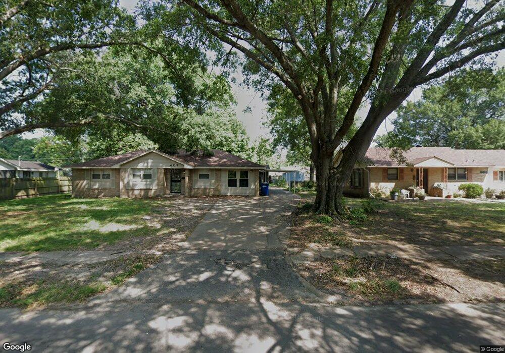
607 Pryor Dr West Memphis, AR 72301
Estimated Value: $180,000 - $202,000
3
Beds
2
Baths
2,303
Sq Ft
$81/Sq Ft
Est. Value
About This Home
This home is located at 607 Pryor Dr, West Memphis, AR 72301 and is currently estimated at $187,602, approximately $81 per square foot. 607 Pryor Dr is a home located in Crittenden County with nearby schools including Richland Elementary School, West Junior High School, and The Academies of West Memphis Charter School.
Ownership History
Date
Name
Owned For
Owner Type
Purchase Details
Closed on
Sep 18, 2020
Sold by
Darby Jerry J and Darby Cheryl L
Bought by
White Dearron Deshawn
Current Estimated Value
Home Financials for this Owner
Home Financials are based on the most recent Mortgage that was taken out on this home.
Original Mortgage
$137,365
Outstanding Balance
$121,676
Interest Rate
2.8%
Mortgage Type
FHA
Estimated Equity
$65,926
Purchase Details
Closed on
Aug 2, 2016
Sold by
Va
Bought by
Darby Jerry L
Purchase Details
Closed on
Sep 1, 2004
Sold by
Not Provided
Bought by
Loomis William E and Loomis Molly A
Create a Home Valuation Report for This Property
The Home Valuation Report is an in-depth analysis detailing your home's value as well as a comparison with similar homes in the area
Home Values in the Area
Average Home Value in this Area
Purchase History
| Date | Buyer | Sale Price | Title Company |
|---|---|---|---|
| White Dearron Deshawn | $139,900 | Stewart Title | |
| Darby Jerry L | $64,444 | Stewart Title | |
| Loomis William E | $110,000 | -- |
Source: Public Records
Mortgage History
| Date | Status | Borrower | Loan Amount |
|---|---|---|---|
| Open | White Dearron Deshawn | $137,365 |
Source: Public Records
Tax History Compared to Growth
Tax History
| Year | Tax Paid | Tax Assessment Tax Assessment Total Assessment is a certain percentage of the fair market value that is determined by local assessors to be the total taxable value of land and additions on the property. | Land | Improvement |
|---|---|---|---|---|
| 2024 | $1,219 | $25,340 | $3,500 | $21,840 |
| 2023 | $1,219 | $25,340 | $3,500 | $21,840 |
| 2022 | $1,219 | $25,340 | $3,500 | $21,840 |
| 2021 | $1,219 | $25,340 | $3,500 | $21,840 |
| 2020 | $1,148 | $25,340 | $3,500 | $21,840 |
| 2019 | $1,022 | $27,030 | $3,500 | $23,530 |
| 2018 | $1,097 | $27,030 | $3,500 | $23,530 |
| 2017 | $1,097 | $0 | $0 | $0 |
| 2016 | $506 | $27,030 | $3,500 | $23,530 |
| 2015 | $515 | $27,030 | $3,500 | $23,530 |
| 2014 | $515 | $21,060 | $3,500 | $17,560 |
Source: Public Records
Map
Nearby Homes
- 603 Highland Dr
- 519 S Roselawn Dr
- 1113 Spears St
- 508 Arlington Dr
- 623 S Roselawn Dr
- 613 Dover Rd
- 1105 Cherry Ln
- 413 Gibson Ave
- 506 Dover Rd
- 607 W Barton Ave
- 813 Pryor Dr
- 808 Dover Rd
- 823 S Roselawn Dr
- 807 W Barton Ave
- 817 Dover Rd
- 321 S Worthington Dr
- 511 W Cooper Ave
- 500 Balfour Rd
- 910 Richland Dr
- 511 Balfour Rd