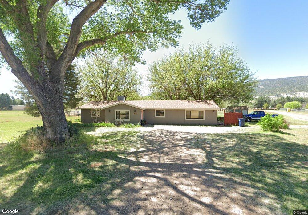
607 W Pheasant Run Cir Camp Verde, AZ 86322
Estimated Value: $487,743 - $632,000
3
Beds
2
Baths
1,664
Sq Ft
$339/Sq Ft
Est. Value
About This Home
This home is located at 607 W Pheasant Run Cir, Camp Verde, AZ 86322 and is currently estimated at $564,186, approximately $339 per square foot. 607 W Pheasant Run Cir is a home located in Yavapai County with nearby schools including Camp Verde Elementary School, Camp Verde Middle School, and Camp Verde High School.
Ownership History
Date
Name
Owned For
Owner Type
Purchase Details
Closed on
Sep 14, 2018
Sold by
Rodger John Michael and Sunfellow Wyatt Jeremia
Bought by
Rodger John Michael and Sunfellow Wyatt Jeremia
Current Estimated Value
Home Financials for this Owner
Home Financials are based on the most recent Mortgage that was taken out on this home.
Original Mortgage
$27,000
Outstanding Balance
$23,497
Interest Rate
4.5%
Mortgage Type
Credit Line Revolving
Estimated Equity
$540,689
Purchase Details
Closed on
Dec 26, 2014
Sold by
Sunfellow Wyatt Jeremia and Rodger John Michael
Bought by
Rodger John Michael and Sunfellow Wyatt Jeremia
Home Financials for this Owner
Home Financials are based on the most recent Mortgage that was taken out on this home.
Original Mortgage
$180,000
Outstanding Balance
$138,480
Interest Rate
3.96%
Mortgage Type
New Conventional
Estimated Equity
$425,706
Purchase Details
Closed on
Oct 20, 2009
Sold by
Deutsche Bank National Trust Company
Bought by
Sunfellow Wyatt Jeremia and Rodger John Michael
Home Financials for this Owner
Home Financials are based on the most recent Mortgage that was taken out on this home.
Original Mortgage
$193,431
Interest Rate
4.83%
Mortgage Type
FHA
Purchase Details
Closed on
Aug 7, 2009
Sold by
Atha Donald E and Atha Barbara L
Bought by
Deutsche Bank National Trust Company
Purchase Details
Closed on
Oct 15, 2008
Sold by
Atha Barbara L
Bought by
Atha Donald E
Purchase Details
Closed on
Nov 13, 1997
Sold by
Baker Michael A
Bought by
Atha Donald E and Atha Barbara L
Home Financials for this Owner
Home Financials are based on the most recent Mortgage that was taken out on this home.
Original Mortgage
$127,720
Interest Rate
7.33%
Mortgage Type
VA
Purchase Details
Closed on
Feb 6, 1995
Sold by
Baker Rebecca L
Bought by
Baker Michael A
Create a Home Valuation Report for This Property
The Home Valuation Report is an in-depth analysis detailing your home's value as well as a comparison with similar homes in the area
Home Values in the Area
Average Home Value in this Area
Purchase History
| Date | Buyer | Sale Price | Title Company |
|---|---|---|---|
| Rodger John Michael | -- | None Available | |
| Rodger John Michael | -- | Lawyers Title | |
| Sunfellow Wyatt Jeremia | $197,000 | Guaranty Title Agency | |
| Deutsche Bank National Trust Company | $208,250 | Lawyers Title Of Arizona | |
| Atha Donald E | -- | None Available | |
| Atha Donald E | $124,000 | Westitle Agency | |
| Baker Michael A | -- | -- |
Source: Public Records
Mortgage History
| Date | Status | Borrower | Loan Amount |
|---|---|---|---|
| Open | Rodger John Michael | $27,000 | |
| Open | Rodger John Michael | $180,000 | |
| Closed | Sunfellow Wyatt Jeremia | $193,431 | |
| Previous Owner | Atha Donald E | $127,720 |
Source: Public Records
Tax History Compared to Growth
Tax History
| Year | Tax Paid | Tax Assessment Tax Assessment Total Assessment is a certain percentage of the fair market value that is determined by local assessors to be the total taxable value of land and additions on the property. | Land | Improvement |
|---|---|---|---|---|
| 2026 | $1,438 | $30,898 | -- | -- |
| 2024 | $1,310 | $30,498 | -- | -- |
| 2023 | $1,390 | $24,409 | $5,269 | $19,140 |
| 2022 | $1,310 | $19,302 | $3,515 | $15,787 |
| 2021 | $1,362 | $18,594 | $4,116 | $14,478 |
| 2020 | $1,314 | $0 | $0 | $0 |
| 2019 | $1,286 | $0 | $0 | $0 |
| 2018 | $1,242 | $0 | $0 | $0 |
| 2017 | $1,177 | $0 | $0 | $0 |
| 2016 | $1,132 | $0 | $0 | $0 |
| 2015 | $1,115 | $0 | $0 | $0 |
| 2014 | -- | $0 | $0 | $0 |
Source: Public Records
Map
Nearby Homes
- 2095 S Hillcrest Dr
- 1993 S Salt Mine Rd
- 1785 S Fort Apache Rd
- 2050 S Hillcrest Dr
- 2045 S Hillcrest Dr
- 1844 S Quarterhorse Ln
- 955 W Copperhead Rd
- 1846 S Dodge Rd
- 452 E Cole Blvd Unit 17
- 452 E Cole Blvd
- 451 W Salt Mine Rd
- 1616 S Reeves Arena Rd
- 2400 S Kynlee Dr Unit 3
- 2400 S Kynlee Dr
- 778 W Salt Mine Rd
- 469 E Cole Blvd Unit 6
- 356 E Cole Blvd Unit 15
- 328 E Cole Blvd Unit 14
- 405 E Cole Blvd Unit 8
- 437 E Cole Blvd Unit 7
- 2148 S Pearl Dr
- 602 W Pheasant Run Cir
- 600 W Fir St
- 650 W Fir St
- 557 W Pheasant Run Cir
- 2208 S Pearl Dr
- 552 W Pheasant Run Cir
- 533 Fir St
- 2098 S Pearl Dr
- 623 W Fir St
- 2238 S Pearl Dr
- 507 W Pheasant Run Cir
- 2058 S Pearl Dr
- 502 W Pheasant Run Cir
- 2035 S Pearl Dr
- 462 W Pheasant Run Cir Unit 2
- 467 W Pheasant Run Cir
- 2038 S Pearl Dr
- 489 W Spruce St
- 469 W Spruce St