Estimated Value: $181,000 - $252,000
3
Beds
2
Baths
1,394
Sq Ft
$154/Sq Ft
Est. Value
About This Home
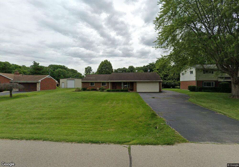
This home is located at 607 Wilson Dr, Xenia, OH 45385 and is currently estimated at $214,755, approximately $154 per square foot. 607 Wilson Dr is a home located in Greene County with nearby schools including Xenia High School, Summit Academy Community School for Alternative Learners - Xenia, and Legacy Christian Academy.
Ownership History
Date
Name
Owned For
Owner Type
Purchase Details
Closed on
Feb 2, 2024
Sold by
Lorenzo Ricky David
Bought by
Howson Laura C
Current Estimated Value
Purchase Details
Closed on
May 21, 2018
Sold by
Lorenzo Julie G
Bought by
Lorenzo Ricky David
Purchase Details
Closed on
Oct 30, 1998
Sold by
Lorenzo Ricky David and Lorenzo Julie G
Bought by
Lorenzo Ricky David and Lorenzo Julie G
Purchase Details
Closed on
Nov 1, 1986
Bought by
Lorenzo Ricky David and Lorenzo Lorenzo
Create a Home Valuation Report for This Property
The Home Valuation Report is an in-depth analysis detailing your home's value as well as a comparison with similar homes in the area
Home Values in the Area
Average Home Value in this Area
Purchase History
| Date | Buyer | Sale Price | Title Company |
|---|---|---|---|
| Howson Laura C | $160,000 | None Listed On Document | |
| Lorenzo Ricky David | -- | None Available | |
| Lorenzo Ricky David | -- | -- | |
| Lorenzo Ricky David | $58,000 | -- |
Source: Public Records
Tax History Compared to Growth
Tax History
| Year | Tax Paid | Tax Assessment Tax Assessment Total Assessment is a certain percentage of the fair market value that is determined by local assessors to be the total taxable value of land and additions on the property. | Land | Improvement |
|---|---|---|---|---|
| 2024 | $2,269 | $47,850 | $9,330 | $38,520 |
| 2023 | $2,269 | $47,850 | $9,330 | $38,520 |
| 2022 | $2,205 | $42,180 | $9,330 | $32,850 |
| 2021 | $2,143 | $42,180 | $9,330 | $32,850 |
| 2020 | $2,143 | $42,180 | $9,330 | $32,850 |
| 2019 | $1,791 | $33,090 | $8,630 | $24,460 |
| 2018 | $1,798 | $33,090 | $8,630 | $24,460 |
| 2017 | $1,663 | $33,090 | $8,630 | $24,460 |
| 2016 | $1,664 | $30,120 | $8,630 | $21,490 |
| 2015 | $1,668 | $30,120 | $8,630 | $21,490 |
| 2014 | $1,600 | $30,120 | $8,630 | $21,490 |
Source: Public Records
Map
Nearby Homes
- 1311 Eagles Way
- 1359 Eagles Way
- 513 Redbud Ln
- 656 Eden Roc Dr
- 610 Saxony Dr
- 508 Marshall Dr
- 1038 Frederick Dr
- 1171 N Detroit St
- 568 Louise Dr
- 902 N Detroit St
- 878 N Detroit St
- 479 N Stadium Dr
- 348 S Stadium Dr
- 659 N King St
- 965 Oak Dale Dr
- 516 N King St
- 119 Park Dr
- 613 N West St
- 983 Echo Ct
- 137 Pleasant St