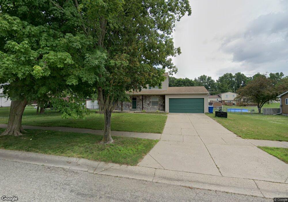
6070 Barker Dr Waterford, MI 48329
Waterford Township NeighborhoodEstimated Value: $297,000 - $320,000
3
Beds
2
Baths
1,496
Sq Ft
$206/Sq Ft
Est. Value
About This Home
This home is located at 6070 Barker Dr, Waterford, MI 48329 and is currently estimated at $308,907, approximately $206 per square foot. 6070 Barker Dr is a home located in Oakland County with nearby schools including Cooley Elementary School, Pierce Middle School, and Waterford Kettering High School.
Ownership History
Date
Name
Owned For
Owner Type
Purchase Details
Closed on
Oct 23, 2020
Sold by
Washnock David H and Washnock April L
Bought by
Washnock April L
Current Estimated Value
Home Financials for this Owner
Home Financials are based on the most recent Mortgage that was taken out on this home.
Original Mortgage
$129,500
Outstanding Balance
$114,973
Interest Rate
2.8%
Mortgage Type
New Conventional
Estimated Equity
$193,934
Purchase Details
Closed on
May 29, 1996
Sold by
Brown Edward C
Bought by
Washnock David M
Home Financials for this Owner
Home Financials are based on the most recent Mortgage that was taken out on this home.
Original Mortgage
$113,850
Interest Rate
8.29%
Create a Home Valuation Report for This Property
The Home Valuation Report is an in-depth analysis detailing your home's value as well as a comparison with similar homes in the area
Home Values in the Area
Average Home Value in this Area
Purchase History
| Date | Buyer | Sale Price | Title Company |
|---|---|---|---|
| Washnock April L | -- | None Available | |
| Washnock David M | $126,500 | -- |
Source: Public Records
Mortgage History
| Date | Status | Borrower | Loan Amount |
|---|---|---|---|
| Open | Washnock April L | $129,500 | |
| Closed | Washnock David M | $113,850 |
Source: Public Records
Tax History Compared to Growth
Tax History
| Year | Tax Paid | Tax Assessment Tax Assessment Total Assessment is a certain percentage of the fair market value that is determined by local assessors to be the total taxable value of land and additions on the property. | Land | Improvement |
|---|---|---|---|---|
| 2024 | $1,546 | $129,720 | $0 | $0 |
| 2023 | $1,475 | $117,440 | $0 | $0 |
| 2022 | $2,440 | $109,980 | $0 | $0 |
| 2021 | $2,311 | $106,290 | $0 | $0 |
| 2020 | $1,350 | $102,440 | $0 | $0 |
| 2019 | $2,259 | $86,830 | $0 | $0 |
| 2018 | $2,242 | $80,910 | $0 | $0 |
| 2017 | $2,067 | $80,910 | $0 | $0 |
| 2016 | $2,063 | $75,400 | $0 | $0 |
| 2015 | -- | $71,170 | $0 | $0 |
| 2014 | -- | $61,760 | $0 | $0 |
| 2011 | -- | $54,220 | $0 | $0 |
Source: Public Records
Map
Nearby Homes
- 2610 Airport Rd
- 2615 Compton Dr
- 6350 Elmwood Dr
- 6175 Hatchery Rd
- 2739 Moosewood Dr Unit 50
- 3077 Nanwich Dr
- 5914 Pleasant Dr
- 6441 Crest Dr
- 6015 Rowley Blvd
- 6376 Lanman Dr
- 2648 Bonita Dr
- 6391 Rowley Blvd
- 6625 Lanman Dr
- 2262 Overridge Ave
- 6275 Williams Lake Rd
- 2351 Overridge Ave
- 5502 Rowley Blvd
- 3194 Whitfield Dr
- 7044 Desmond Rd
- 2685 Diane Marie Ct Unit 1
- 6066 Barker Dr
- 2760 Campbellgate Dr
- 2675 Airport Rd
- 2774 Campbellgate Dr
- 2663 Airport Rd
- 6062 Barker Dr
- 6071 Barker Dr
- 2744 Campbellgate Dr Unit Bldg-Unit
- 2744 Campbellgate Dr
- 2790 Campbellgate Dr
- 2651 Airport Rd
- 6065 Barker Dr
- 6053 Barker Dr
- 6058 Barker Dr Unit Bldg-Unit
- 6058 Barker Dr
- 2639 Airport Rd Unit Bldg-Unit
- 2639 Airport Rd
- 2757 Campbellgate Dr
- 2732 Campbellgate Dr
- 2773 Campbellgate Dr