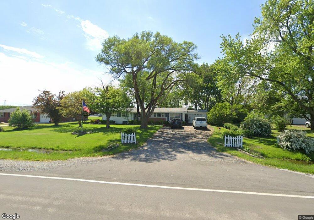
6075 Lake Rd Mattoon, IL 61938
Estimated Value: $140,000 - $176,245
3
Beds
2
Baths
1,944
Sq Ft
$84/Sq Ft
Est. Value
About This Home
This home is located at 6075 Lake Rd, Mattoon, IL 61938 and is currently estimated at $164,061, approximately $84 per square foot. 6075 Lake Rd is a home located in Coles County with nearby schools including Mattoon High School, St Mary School, and Heritage Baptist Academy.
Ownership History
Date
Name
Owned For
Owner Type
Purchase Details
Closed on
Apr 22, 2023
Sold by
Puckett Family Declaration Of Trust
Bought by
Janes Charlotta
Current Estimated Value
Purchase Details
Closed on
Jan 29, 2016
Sold by
Browning Steven L and Janes Charlotta
Bought by
Steve D Puckett and Carlissa R Puckett
Purchase Details
Closed on
Dec 31, 2015
Sold by
Browning Trust
Bought by
Puckett Carlissa R and Browning Steven
Purchase Details
Closed on
Oct 14, 2015
Sold by
Janes Charlotta and Browning Steven
Bought by
Puckett Carlissa
Purchase Details
Closed on
Dec 30, 2014
Sold by
Puckett Steven D and Puckett Carlissa R
Bought by
Puckett Family
Create a Home Valuation Report for This Property
The Home Valuation Report is an in-depth analysis detailing your home's value as well as a comparison with similar homes in the area
Home Values in the Area
Average Home Value in this Area
Purchase History
| Date | Buyer | Sale Price | Title Company |
|---|---|---|---|
| Janes Charlotta | $125,000 | None Listed On Document | |
| Steve D Puckett | -- | -- | |
| Puckett Carlissa R | -- | -- | |
| Browning Trust | -- | -- | |
| Puckett Carlissa | -- | -- | |
| Puckett Family | -- | -- |
Source: Public Records
Tax History Compared to Growth
Tax History
| Year | Tax Paid | Tax Assessment Tax Assessment Total Assessment is a certain percentage of the fair market value that is determined by local assessors to be the total taxable value of land and additions on the property. | Land | Improvement |
|---|---|---|---|---|
| 2024 | $1,943 | $35,882 | $5,387 | $30,495 |
| 2023 | $2,177 | $32,038 | $4,810 | $27,228 |
| 2022 | $2,139 | $31,509 | $4,731 | $26,778 |
| 2021 | $2,161 | $28,942 | $4,346 | $24,596 |
| 2020 | $2,150 | $29,987 | $4,503 | $25,484 |
| 2019 | $1,681 | $28,942 | $4,346 | $24,596 |
| 2018 | $1,657 | $28,942 | $4,346 | $24,596 |
| 2017 | $1,658 | $28,942 | $4,346 | $24,596 |
| 2016 | $1,628 | $28,942 | $4,346 | $24,596 |
| 2015 | $887 | $28,942 | $4,346 | $24,596 |
| 2014 | $887 | $28,942 | $4,346 | $24,596 |
| 2013 | $887 | $28,942 | $4,346 | $24,596 |
Source: Public Records
Map
Nearby Homes
- 3512 Walnut Ave
- 9 Joan Marie Dr
- 3304 Marion Ave
- 421 Parkview Ave
- 2921 Oak Ave
- 3105 Marshall Ave
- 3216 Western Ave
- 3000 Western Ave
- 2801 Commercial Ave
- 3324 Shelby Ave
- 3105 Champaign Ave
- 2808 Western Ave
- 2808 Prairie Ave
- 2913 Champaign Ave
- 2505 Pine Ave
- 2502 Pine Ave
- 113 S 25th St
- 2808 Champaign Ave
- 2921 Moultrie Ave
- 2720 Champaign Ave