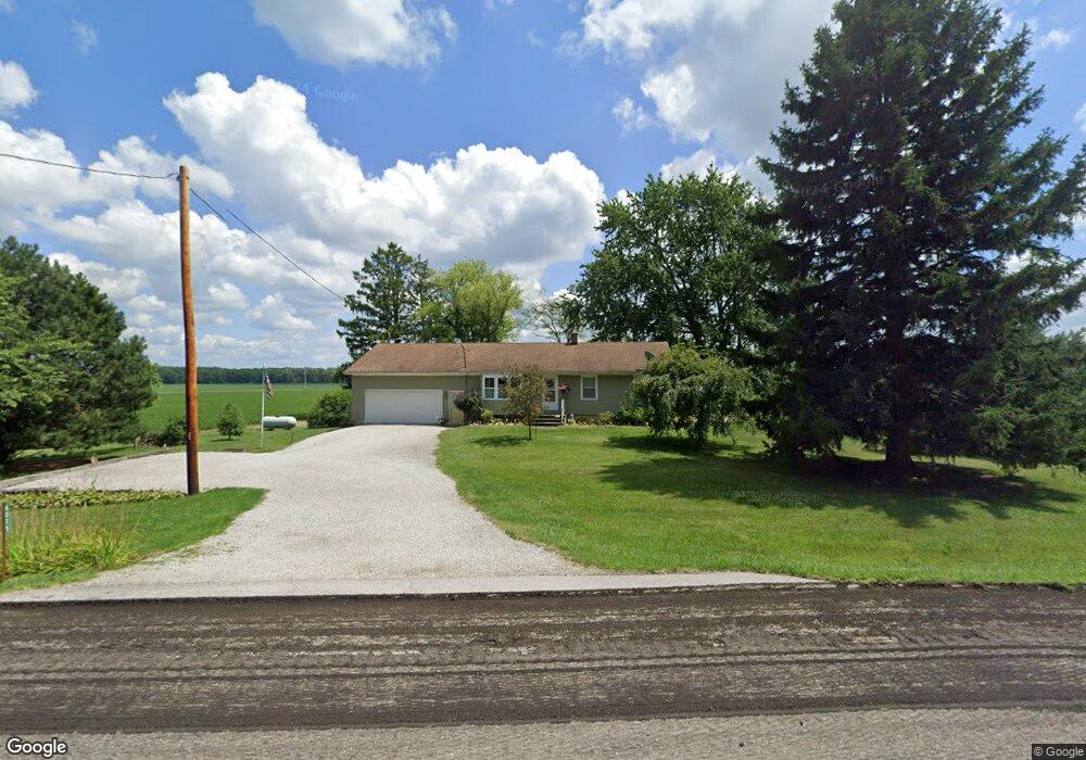
6075 State Route 547 Bellevue, OH 44811
Estimated Value: $148,000 - $223,000
3
Beds
1
Bath
1,120
Sq Ft
$158/Sq Ft
Est. Value
About This Home
This home is located at 6075 State Route 547, Bellevue, OH 44811 and is currently estimated at $176,617, approximately $157 per square foot. 6075 State Route 547 is a home located in Huron County with nearby schools including Bellevue Elementary School, Bellevue Middle School, and Bellevue High School.
Ownership History
Date
Name
Owned For
Owner Type
Purchase Details
Closed on
Feb 1, 2011
Bought by
William D Heimbaugh
Current Estimated Value
Purchase Details
Closed on
Jul 21, 2010
Bought by
Federal National Mortgage Association
Purchase Details
Closed on
Oct 22, 2004
Bought by
Wikel Lois
Purchase Details
Closed on
Apr 23, 2003
Bought by
Francis Lois
Purchase Details
Closed on
May 29, 1996
Sold by
Baxter Dorothy
Bought by
Francis Allen D
Purchase Details
Closed on
Dec 10, 1993
Bought by
Baxter Dorothy M
Create a Home Valuation Report for This Property
The Home Valuation Report is an in-depth analysis detailing your home's value as well as a comparison with similar homes in the area
Home Values in the Area
Average Home Value in this Area
Purchase History
| Date | Buyer | Sale Price | Title Company |
|---|---|---|---|
| William D Heimbaugh | $63,000 | -- | |
| Federal National Mortgage Association | $43,300 | -- | |
| Wikel Lois | -- | -- | |
| Francis Lois | -- | -- | |
| Francis Allen D | $38,300 | -- | |
| Baxter Dorothy M | -- | -- |
Source: Public Records
Mortgage History
| Date | Status | Borrower | Loan Amount |
|---|---|---|---|
| Closed | Francis Allen D | -- |
Source: Public Records
Tax History Compared to Growth
Tax History
| Year | Tax Paid | Tax Assessment Tax Assessment Total Assessment is a certain percentage of the fair market value that is determined by local assessors to be the total taxable value of land and additions on the property. | Land | Improvement |
|---|---|---|---|---|
| 2024 | $1,825 | $43,870 | $7,740 | $36,130 |
| 2023 | $1,825 | $29,910 | $5,600 | $24,310 |
| 2022 | $1,328 | $29,910 | $5,600 | $24,310 |
| 2021 | $1,340 | $29,910 | $5,600 | $24,310 |
| 2020 | $1,368 | $29,030 | $4,420 | $24,610 |
| 2019 | $1,346 | $29,030 | $4,420 | $24,610 |
| 2018 | $1,299 | $29,030 | $4,420 | $24,610 |
| 2017 | $1,161 | $26,740 | $4,330 | $22,410 |
| 2016 | $1,125 | $26,740 | $4,330 | $22,410 |
| 2015 | $1,151 | $26,750 | $4,330 | $22,420 |
| 2014 | $1,195 | $26,780 | $4,340 | $22,440 |
| 2013 | $1,193 | $26,780 | $4,340 | $22,440 |
Source: Public Records
Map
Nearby Homes
- 7740 Washington St
- 3050 E Main St
- 3851 Everingin Rd
- 140 Hobson St
- 111 Park Ave
- 501 E Center St
- 817 E Main St
- 881 Flat Rock Rd
- 736 Kilbourne St
- 720 Kilbourne St
- 206 Southwest St
- 140 Harkness St
- 818 Bellaire Dr
- 129 Hamilton St
- 155 Ashford Ave
- 154 Ashford Ave
- 803 Del Moy Ave
- 0 Hartland Dr
- 231 Lawrence St
- 126 Greenwood Heights
- 6080 State Route 547
- 6096 State Route 547
- 6050 State Route 547
- 2474 State Route 4
- 2337 State Route 4
- 2337 Ohio 4
- 2638 Ohio 4
- 2228 State Route 4
- 2228 State Route 4
- 6386 State Route 547
- 2206 State Route 4
- 2201 State Route 4
- 2605 State Route 4
- 5725 State Route 547
- 1935 Heyman Rd
- 2100 State Route 4
- 2126 State Route 4
- 2701 State Route 4
- 6517 State Route 547
- 6517 Ohio 547