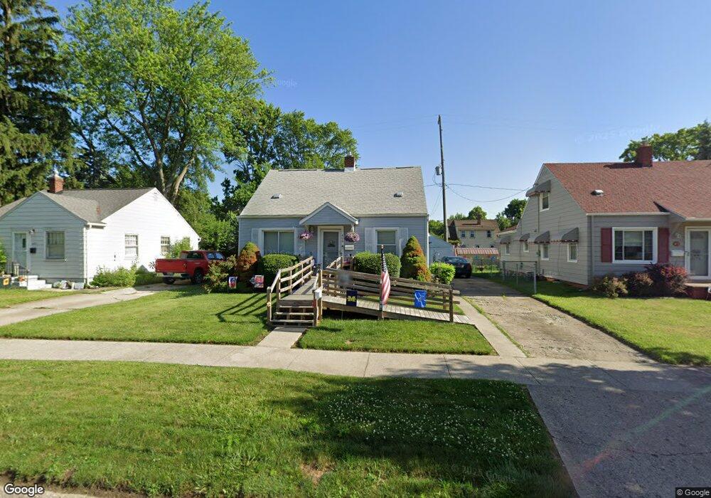
609 Burroughs Ave Flint, MI 48507
Circle Drive NeighborhoodEstimated Value: $71,000 - $89,000
2
Beds
1
Bath
1,240
Sq Ft
$64/Sq Ft
Est. Value
About This Home
This home is located at 609 Burroughs Ave, Flint, MI 48507 and is currently estimated at $79,954, approximately $64 per square foot. 609 Burroughs Ave is a home located in Genesee County with nearby schools including Freeman Elementary School, Flint Southwestern Classical Academy, and Burton Glen Charter Academy.
Ownership History
Date
Name
Owned For
Owner Type
Purchase Details
Closed on
Jan 30, 2017
Sold by
Downie Sherri L and Downie Gerald L
Bought by
Downie Sherri L and Downie Gerald L
Current Estimated Value
Purchase Details
Closed on
Dec 3, 2015
Sold by
Brophy Adam James
Bought by
Downie Sherri
Purchase Details
Closed on
Jul 18, 2011
Sold by
Downie Sherri
Bought by
Downie Sherri and Brophy Adam
Purchase Details
Closed on
Mar 18, 2011
Sold by
Manley Wendy
Bought by
Downie Sherri
Create a Home Valuation Report for This Property
The Home Valuation Report is an in-depth analysis detailing your home's value as well as a comparison with similar homes in the area
Home Values in the Area
Average Home Value in this Area
Purchase History
| Date | Buyer | Sale Price | Title Company |
|---|---|---|---|
| Downie Sherri L | -- | None Available | |
| Dowie Sherri L | -- | None Available | |
| Downie Sherri | -- | Attorney | |
| Downie Sherri | -- | None Available | |
| Downie Sherri | $11,000 | Lighthouse Title Inc |
Source: Public Records
Tax History
| Year | Tax Paid | Tax Assessment Tax Assessment Total Assessment is a certain percentage of the fair market value that is determined by local assessors to be the total taxable value of land and additions on the property. | Land | Improvement |
|---|---|---|---|---|
| 2025 | $1,098 | $37,300 | $0 | $0 |
| 2024 | $991 | $33,300 | $0 | $0 |
| 2023 | $971 | $29,200 | $0 | $0 |
| 2022 | $0 | $23,800 | $0 | $0 |
| 2021 | $1,012 | $24,500 | $0 | $0 |
| 2020 | $909 | $19,400 | $0 | $0 |
| 2019 | $883 | $15,400 | $0 | $0 |
| 2018 | $891 | $13,700 | $0 | $0 |
| 2017 | $866 | $0 | $0 | $0 |
| 2016 | $860 | $0 | $0 | $0 |
| 2015 | -- | $0 | $0 | $0 |
| 2014 | -- | $0 | $0 | $0 |
| 2012 | -- | $17,100 | $0 | $0 |
Source: Public Records
Map
Nearby Homes
- 621 Burroughs Ave
- 630 Buckingham Ave
- 621 Lochhead Ave
- 416 Burroughs Ave
- 4133 Custer Ave
- 4127 Custer Ave
- 617 McKeighan Ave
- 530 McKeighan Ave
- 4205 Red Arrow Rd
- 818 Dell Ave
- 361 Buckingham Ave
- 3505 Comanche Ave
- 802 McKeighan Ave
- 352 Buckingham Ave
- 1111 Lochhead Ave
- 326 Burroughs Ave
- 4424 Cheyenne Ave
- 3115 Circle Dr
- 338 Browning Ave
- 3209 Shawnee Ave
- 613 Burroughs Ave
- 605 Burroughs Ave
- 617 Burroughs Ave
- 610 Buckingham Ave
- 606 Buckingham Ave
- 614 Buckingham Ave
- 618 Buckingham Ave
- 549 Burroughs Ave
- 610 Burroughs Ave
- 614 Burroughs Ave
- 606 Burroughs Ave
- 622 Buckingham Ave
- 548 Buckingham Ave
- 618 Burroughs Ave
- 625 Burroughs Ave
- 545 Burroughs Ave
- 602 Burroughs Ave
- 548 Burroughs Ave
- 626 Buckingham Ave
- 544 Buckingham Ave
Your Personal Tour Guide
Ask me questions while you tour the home.