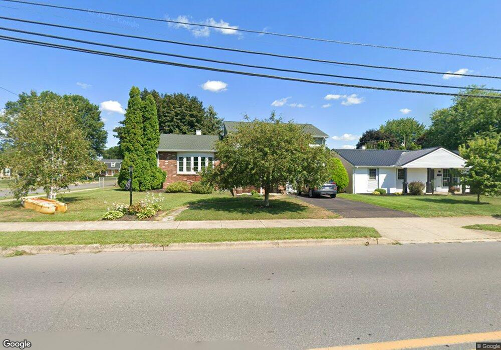
609 N Broad St Selinsgrove, PA 17870
Estimated Value: $219,199 - $284,000
--
Bed
--
Bath
--
Sq Ft
8,712
Sq Ft Lot
About This Home
This home is located at 609 N Broad St, Selinsgrove, PA 17870 and is currently estimated at $254,050. 609 N Broad St is a home located in Snyder County with nearby schools including Selinsgrove Area Elementary School, Selinsgrove Intermediate School, and Selinsgrove Area Middle School.
Ownership History
Date
Name
Owned For
Owner Type
Purchase Details
Closed on
Jul 29, 2025
Sold by
Reichenbach Makayla Brooke and Reichenbach Bryce Alan
Bought by
Reichenbach Bryce Alan and Reichenbach Makayla Brooke
Current Estimated Value
Purchase Details
Closed on
Jul 5, 2023
Sold by
Richards Darcy A
Bought by
Reichenbach Bryce Alan and Hockenbrock Makayla Brooke
Home Financials for this Owner
Home Financials are based on the most recent Mortgage that was taken out on this home.
Original Mortgage
$225,000
Interest Rate
5.63%
Mortgage Type
New Conventional
Create a Home Valuation Report for This Property
The Home Valuation Report is an in-depth analysis detailing your home's value as well as a comparison with similar homes in the area
Home Values in the Area
Average Home Value in this Area
Purchase History
| Date | Buyer | Sale Price | Title Company |
|---|---|---|---|
| Reichenbach Bryce Alan | -- | None Listed On Document | |
| Reichenbach Bryce Alan | $240,000 | None Listed On Document |
Source: Public Records
Mortgage History
| Date | Status | Borrower | Loan Amount |
|---|---|---|---|
| Previous Owner | Reichenbach Bryce Alan | $225,000 |
Source: Public Records
Tax History Compared to Growth
Tax History
| Year | Tax Paid | Tax Assessment Tax Assessment Total Assessment is a certain percentage of the fair market value that is determined by local assessors to be the total taxable value of land and additions on the property. | Land | Improvement |
|---|---|---|---|---|
| 2025 | $3,065 | $25,620 | $5,100 | $20,520 |
| 2024 | $2,877 | $25,620 | $5,100 | $20,520 |
| 2023 | $1,148 | $25,620 | $5,100 | $20,520 |
| 2022 | $2,762 | $25,620 | $5,100 | $20,520 |
| 2021 | $2,736 | $25,620 | $5,100 | $20,520 |
| 2020 | $2,723 | $25,620 | $5,100 | $20,520 |
| 2019 | $2,711 | $25,620 | $5,100 | $20,520 |
| 2018 | $2,685 | $25,620 | $5,100 | $20,520 |
| 2017 | $2,659 | $25,620 | $5,100 | $20,520 |
| 2016 | $1,430 | $25,620 | $5,100 | $20,520 |
| 2015 | $94,314 | $25,620 | $5,100 | $20,520 |
| 2014 | $94,314 | $25,620 | $5,100 | $20,520 |
Source: Public Records
Map
Nearby Homes
- 501 N 9th St
- 722 N 8th St
- 500 N Orange St
- 207 Orange St Unit 209
- 21 Calvett Place
- Lot 1 522 Route S
- 104 18th St
- 20 Quarry Rd
- 223 E Pine St
- 301 E Pine St
- 321 Pleasant Dr
- 301 E Walnut St
- 456 State School Rd
- 34 Oakmont Ct
- 0 Mill Rd
- 85 Old Colony Rd
- 1262 N Old Trail
- 594 Augusta Dr
- 107 Saint Andrews Way
- 81 Saint Andrews Way