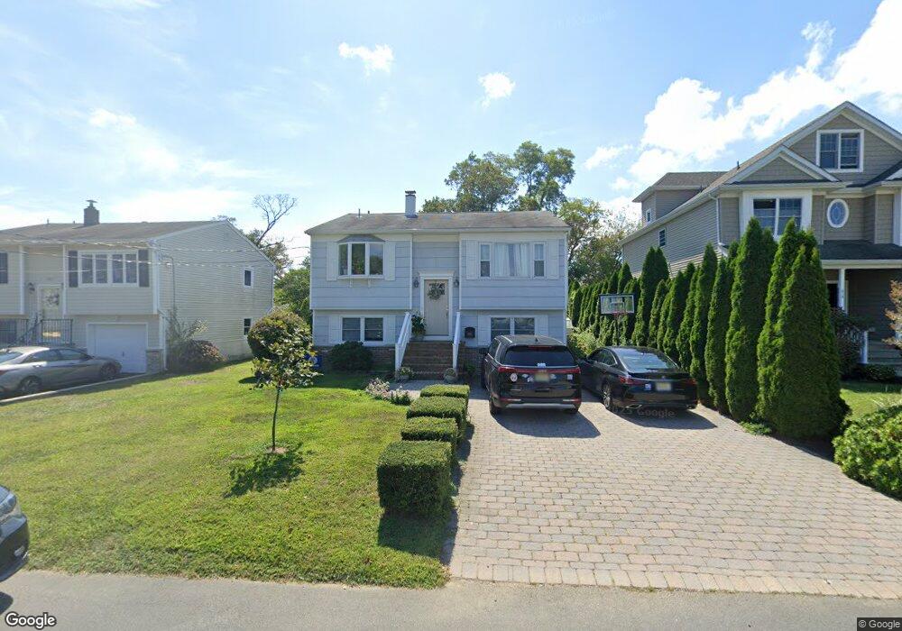
609 Park Ave Brielle, NJ 08730
Estimated Value: $791,000 - $1,004,000
4
Beds
2
Baths
1,765
Sq Ft
$496/Sq Ft
Est. Value
About This Home
This home is located at 609 Park Ave, Brielle, NJ 08730 and is currently estimated at $876,301, approximately $496 per square foot. 609 Park Ave is a home located in Monmouth County with nearby schools including Brielle Elementary School and St. Peter School.
Ownership History
Date
Name
Owned For
Owner Type
Purchase Details
Closed on
Nov 15, 2005
Sold by
Jones Brandon
Bought by
Jones Jrhosaboy and Jones Magdalis
Current Estimated Value
Home Financials for this Owner
Home Financials are based on the most recent Mortgage that was taken out on this home.
Original Mortgage
$336,000
Interest Rate
6.33%
Mortgage Type
New Conventional
Purchase Details
Closed on
Nov 1, 2002
Sold by
Jones John
Bought by
Jones Brandan
Home Financials for this Owner
Home Financials are based on the most recent Mortgage that was taken out on this home.
Original Mortgage
$120,000
Interest Rate
6.19%
Create a Home Valuation Report for This Property
The Home Valuation Report is an in-depth analysis detailing your home's value as well as a comparison with similar homes in the area
Home Values in the Area
Average Home Value in this Area
Purchase History
| Date | Buyer | Sale Price | Title Company |
|---|---|---|---|
| Jones Jrhosaboy | $420,000 | -- | |
| Jones Brandan | $150,000 | -- |
Source: Public Records
Mortgage History
| Date | Status | Borrower | Loan Amount |
|---|---|---|---|
| Previous Owner | Jones Jrhosaboy | $336,000 | |
| Previous Owner | Jones Brandan | $120,000 |
Source: Public Records
Tax History
| Year | Tax Paid | Tax Assessment Tax Assessment Total Assessment is a certain percentage of the fair market value that is determined by local assessors to be the total taxable value of land and additions on the property. | Land | Improvement |
|---|---|---|---|---|
| 2025 | $8,219 | $687,700 | $480,500 | $207,200 |
| 2024 | $7,756 | $662,300 | $458,900 | $203,400 |
| 2023 | $7,756 | $603,600 | $405,000 | $198,600 |
| 2022 | $6,245 | $563,600 | $380,000 | $183,600 |
| 2021 | $6,245 | $407,400 | $260,000 | $147,400 |
| 2020 | $6,615 | $404,100 | $260,000 | $144,100 |
| 2019 | $6,505 | $403,300 | $260,000 | $143,300 |
| 2018 | $6,644 | $406,600 | $270,000 | $136,600 |
| 2017 | $6,408 | $387,400 | $255,000 | $132,400 |
| 2016 | $6,871 | $416,200 | $255,000 | $161,200 |
| 2015 | $6,800 | $408,900 | $255,000 | $153,900 |
| 2014 | $7,215 | $463,100 | $357,500 | $105,600 |
Source: Public Records
Map
Nearby Homes
Your Personal Tour Guide
Ask me questions while you tour the home.