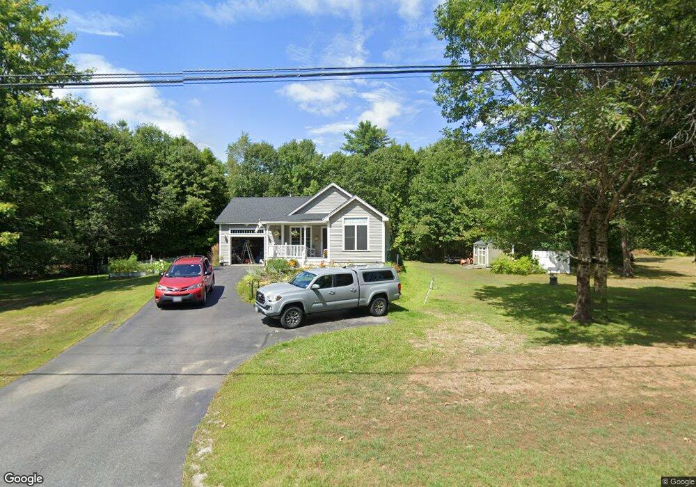
609 Range E Rd Limerick, ME 04048
Estimated Value: $403,434 - $469,000
4
Beds
3
Baths
1,408
Sq Ft
$305/Sq Ft
Est. Value
About This Home
This home is located at 609 Range E Rd, Limerick, ME 04048 and is currently estimated at $429,859, approximately $305 per square foot. 609 Range E Rd is a home located in York County with nearby schools including Massabesic High School.
Ownership History
Date
Name
Owned For
Owner Type
Purchase Details
Closed on
Aug 26, 2024
Sold by
Lehmann Andrew T and Lehmann Linda E
Bought by
Lehmann Andrew T and Lehmann Linda E
Current Estimated Value
Create a Home Valuation Report for This Property
The Home Valuation Report is an in-depth analysis detailing your home's value as well as a comparison with similar homes in the area
Home Values in the Area
Average Home Value in this Area
Purchase History
| Date | Buyer | Sale Price | Title Company |
|---|---|---|---|
| Lehmann Andrew T | -- | None Available | |
| Lehmann Andrew T | -- | None Available |
Source: Public Records
Tax History
| Year | Tax Paid | Tax Assessment Tax Assessment Total Assessment is a certain percentage of the fair market value that is determined by local assessors to be the total taxable value of land and additions on the property. | Land | Improvement |
|---|---|---|---|---|
| 2025 | $3,558 | $374,573 | $91,056 | $283,517 |
| 2024 | $3,558 | $374,573 | $91,056 | $283,517 |
| 2023 | $3,782 | $248,835 | $46,400 | $202,435 |
| 2022 | $3,533 | $248,835 | $46,400 | $202,435 |
| 2021 | $3,305 | $199,068 | $37,120 | $161,948 |
| 2020 | $3,265 | $199,068 | $37,120 | $161,948 |
| 2019 | $3,135 | $199,068 | $37,120 | $161,948 |
| 2018 | $3,215 | $199,068 | $37,120 | $161,948 |
| 2017 | $3,135 | $199,068 | $37,120 | $161,948 |
| 2016 | $2,996 | $199,068 | $37,120 | $161,948 |
| 2015 | $2,906 | $199,068 | $37,120 | $161,948 |
| 2014 | $2,817 | $199,068 | $37,120 | $161,948 |
Source: Public Records
Map
Nearby Homes
- 451 Range E Rd
- 515 Range East Rd
- 545 Foss Rd
- 0 Stone Hill Rd
- 0 Mowry 0 Row Mowry Ln
- 590 Newfield Rd
- 5 Wescott St
- 220 Bond Spring Rd
- TBD Sokokis Trail & Beaver Brook Rd
- TBB Sokokis Trail & Beaver Brook Rd
- 25 Onamor Dr
- 0 Quarry Rd
- 24 Emery Corner Rd
- 4 Deer Crossing Rd
- 50 Island Rd
- LOT# 8 Business Park Rd
- Lot# 11 Business Park Rd
- 0 Island Rd Unit 1643509
- M13L30 Clarks Bridge Rd
- 240 Leisure Ln
- 601 Range E Rd
- 627 Range E Rd
- 681 Elm St
- 671 Elm St
- 661 Elm St
- 9999 ''''''E'''' Range Rd
- 9998 ''''''E'''' Range Ro
- 639 Elm St
- 622 Elm St
- 15 Nutter Ln
- 271 Patterson Rd
- 551 Range E Rd
- 621 Elm St
- 267 Patterson Rd
- 531 Range E Rd
- 787 Water St
- 255 Patterson Rd
- 263 Patterson Rd
- 254 Patterson Rd
- 251 Patterson Rd
Your Personal Tour Guide
Ask me questions while you tour the home.