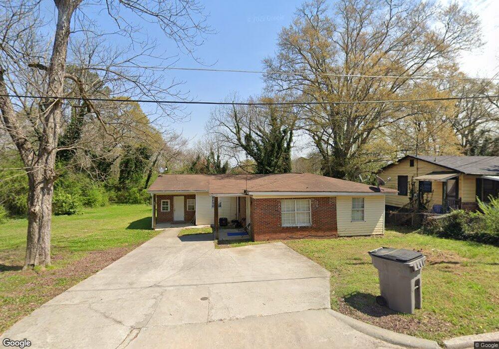
609 Snelson St Lagrange, GA 30241
Estimated Value: $88,000 - $209,000
4
Beds
2
Baths
1,875
Sq Ft
$79/Sq Ft
Est. Value
About This Home
This home is located at 609 Snelson St, Lagrange, GA 30241 and is currently estimated at $148,809, approximately $79 per square foot. 609 Snelson St is a home located in Troup County with nearby schools including Hollis Hand Elementary School, Franklin Forest Elementary School, and Ethel W. Kight Elementary School.
Ownership History
Date
Name
Owned For
Owner Type
Purchase Details
Closed on
Jul 6, 2012
Sold by
Federal National Mortgage Association
Bought by
Farrar Fred M
Current Estimated Value
Purchase Details
Closed on
Jun 7, 2011
Sold by
Wells Fargo Bank Na
Bought by
Federal National Mortgage Association
Purchase Details
Closed on
Mar 5, 2008
Sold by
Davidson Fred J
Bought by
Gresham Jennie H
Purchase Details
Closed on
Mar 15, 2007
Sold by
Hubbard Ruby J
Bought by
Davidson Fred L
Purchase Details
Closed on
May 8, 2000
Sold by
Walter Hubbard
Bought by
Ruby J Hubbard
Purchase Details
Closed on
May 25, 1979
Sold by
Walter Hubbard
Bought by
Walter Hubbard
Purchase Details
Closed on
May 1, 1969
Sold by
Hubbard Hubbard and Hubbard Turner
Bought by
Walter Hubbard
Purchase Details
Closed on
Jan 1, 1945
Bought by
Hubbard Hubbard and Hubbard Turner
Create a Home Valuation Report for This Property
The Home Valuation Report is an in-depth analysis detailing your home's value as well as a comparison with similar homes in the area
Purchase History
| Date | Buyer | Sale Price | Title Company |
|---|---|---|---|
| Farrar Fred M | $24,000 | -- | |
| Federal National Mortgage Association | $22,100 | -- | |
| Wells Fargo Bank Na | $22,100 | -- | |
| Gresham Jennie H | -- | -- | |
| Davidson Fred L | -- | -- | |
| Ruby J Hubbard | -- | -- | |
| Walter Hubbard | -- | -- | |
| Walter Hubbard | -- | -- | |
| Hubbard Hubbard | -- | -- |
Source: Public Records
Tax History
| Year | Tax Paid | Tax Assessment Tax Assessment Total Assessment is a certain percentage of the fair market value that is determined by local assessors to be the total taxable value of land and additions on the property. | Land | Improvement |
|---|---|---|---|---|
| 2025 | $908 | $33,280 | $3,080 | $30,200 |
| 2024 | $816 | $29,920 | $3,080 | $26,840 |
| 2023 | $815 | $29,880 | $3,080 | $26,800 |
| 2022 | $794 | $28,440 | $3,080 | $25,360 |
| 2021 | $542 | $17,960 | $1,840 | $16,120 |
| 2020 | $542 | $17,960 | $1,840 | $16,120 |
| 2019 | $510 | $16,920 | $1,840 | $15,080 |
| 2018 | $509 | $16,880 | $1,800 | $15,080 |
| 2017 | $509 | $16,880 | $1,800 | $15,080 |
| 2016 | $507 | $16,815 | $1,800 | $15,015 |
| 2015 | $510 | $16,880 | $1,865 | $15,015 |
| 2014 | $487 | $16,090 | $1,865 | $14,225 |
| 2013 | -- | $17,380 | $1,865 | $15,515 |
Source: Public Records
Map
Nearby Homes
- 613 Snelson St
- 615 Snelson St
- 603 Snelson St
- 601 Snelson St
- 512 Burr St
- 612 Snelson St Unit S A & B
- 612 Snelson St
- 608 Snelson St
- 599 Snelson St
- 617 Snelson St
- 514 Burr St
- 508 Burr St
- 314 Mccall St
- 405 Mccall St
- 0 Mccall St Unit 8548795
- 0 Mccall St Unit 8548785
- 313 Mccall St
- 404 Revis St
- 400 Revis St
- 406 Revis St
Your Personal Tour Guide
Ask me questions while you tour the home.