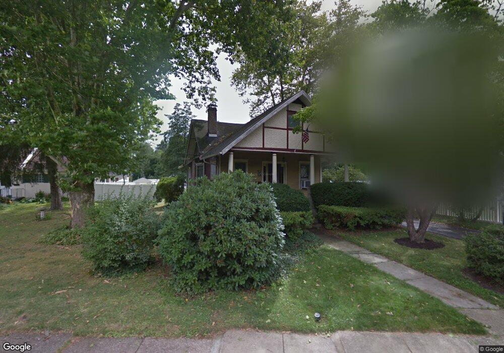
609 W Atlantic Ave Laurel Springs, NJ 08021
Estimated Value: $263,391 - $345,000
--
Bed
--
Bath
1,520
Sq Ft
$201/Sq Ft
Est. Value
About This Home
This home is located at 609 W Atlantic Ave, Laurel Springs, NJ 08021 and is currently estimated at $305,598, approximately $201 per square foot. 609 W Atlantic Ave is a home located in Camden County with nearby schools including Laurel Springs School, Saint John Paul II Regional School, and Trinity Preparatory School Inc..
Ownership History
Date
Name
Owned For
Owner Type
Purchase Details
Closed on
Sep 2, 2020
Sold by
Mai Elizabeth T
Bought by
Mai Brian
Current Estimated Value
Purchase Details
Closed on
Apr 20, 1995
Sold by
Moran James G
Bought by
Mai Brian and Mai Elizabeth
Home Financials for this Owner
Home Financials are based on the most recent Mortgage that was taken out on this home.
Original Mortgage
$88,000
Interest Rate
8.31%
Create a Home Valuation Report for This Property
The Home Valuation Report is an in-depth analysis detailing your home's value as well as a comparison with similar homes in the area
Home Values in the Area
Average Home Value in this Area
Purchase History
| Date | Buyer | Sale Price | Title Company |
|---|---|---|---|
| Mai Brian | -- | None Available | |
| Mai Brian | -- | None Listed On Document | |
| Mai Brian | $92,950 | -- |
Source: Public Records
Mortgage History
| Date | Status | Borrower | Loan Amount |
|---|---|---|---|
| Previous Owner | Mai Brian | $88,000 |
Source: Public Records
Tax History Compared to Growth
Tax History
| Year | Tax Paid | Tax Assessment Tax Assessment Total Assessment is a certain percentage of the fair market value that is determined by local assessors to be the total taxable value of land and additions on the property. | Land | Improvement |
|---|---|---|---|---|
| 2025 | $8,051 | $144,700 | $34,800 | $109,900 |
| 2024 | $7,802 | $144,700 | $34,800 | $109,900 |
| 2023 | $7,802 | $144,700 | $34,800 | $109,900 |
| 2022 | $7,678 | $144,700 | $34,800 | $109,900 |
| 2021 | $7,607 | $144,700 | $34,800 | $109,900 |
| 2020 | $7,516 | $144,700 | $34,800 | $109,900 |
| 2019 | $760 | $144,700 | $34,800 | $109,900 |
| 2018 | $7,377 | $144,700 | $34,800 | $109,900 |
| 2017 | $7,157 | $144,700 | $34,800 | $109,900 |
| 2016 | $7,163 | $95,400 | $30,500 | $64,900 |
| 2015 | $6,998 | $95,400 | $30,500 | $64,900 |
| 2014 | $6,890 | $95,400 | $30,500 | $64,900 |
Source: Public Records
Map
Nearby Homes
- 427 W Maple Ave
- 316 E Stafford Ave
- 514 Park Ave
- 202 Broadway
- 135 Madison Ave
- 104 W Park Ave
- 116 W Park Ave
- 125 Madison Ave
- 135 Mount Vernon Ave
- 335 2nd Ave
- 105 Summit Ave
- 118 1st Ave
- 25 State Ave
- 513 N White Horse Pike
- 503 Laurel Rd
- 605 4th Ave
- 823 N White Horse Pike
- 312 Wallace Ave
- 5 S White Horse Pike
- 126 E Linden Ave
- 601 W Atlantic Ave
- 417 Lindsay Ave
- 617 W Atlantic Ave
- 410 W Maple Ave
- 419 Lindsay Ave
- 414 W Maple Ave
- 623 W Atlantic Ave
- 429 Lindsay Ave
- 521 W Atlantic Ave
- 433 Lindsay Ave
- 424 W Maple Ave
- 435 Lindsay Ave
- 511 W Atlantic Ave
- 418 Lindsay Ave
- 410 Lindsay Ave
- 602 E Atlantic Ave
- 419 W Maple Ave
- 426 Lindsay Ave
- 705 W Atlantic Ave
- 516 E Atlantic Ave