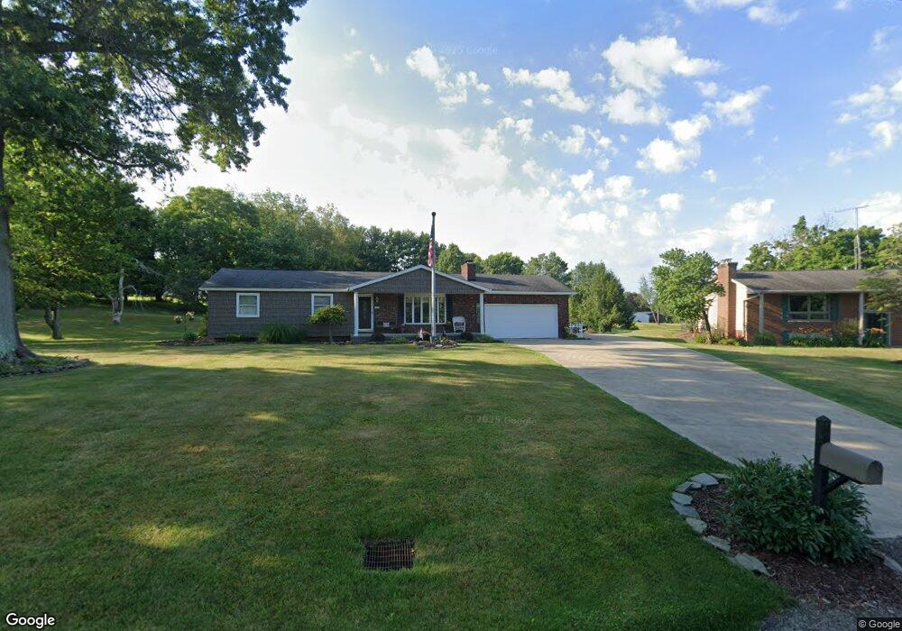
6090 Pilot View Cir Louisville, OH 44641
Estimated Value: $236,000 - $275,000
3
Beds
2
Baths
1,266
Sq Ft
$202/Sq Ft
Est. Value
About This Home
This home is located at 6090 Pilot View Cir, Louisville, OH 44641 and is currently estimated at $256,118, approximately $202 per square foot. 6090 Pilot View Cir is a home located in Stark County with nearby schools including Louisville High School and St. Thomas Aquinas High School & Middle School.
Ownership History
Date
Name
Owned For
Owner Type
Purchase Details
Closed on
Apr 14, 2016
Sold by
Mccauley John G and Mccauley Julia M
Bought by
Mccauley John G and Mccauley Julia M
Current Estimated Value
Purchase Details
Closed on
Jul 1, 2004
Sold by
Mccauley John G and Mccauley Julia M
Bought by
Mccauley John G and Mccauley Julia M
Create a Home Valuation Report for This Property
The Home Valuation Report is an in-depth analysis detailing your home's value as well as a comparison with similar homes in the area
Home Values in the Area
Average Home Value in this Area
Purchase History
| Date | Buyer | Sale Price | Title Company |
|---|---|---|---|
| Mccauley John G | -- | None Available | |
| Mccauley John G | -- | -- |
Source: Public Records
Tax History Compared to Growth
Tax History
| Year | Tax Paid | Tax Assessment Tax Assessment Total Assessment is a certain percentage of the fair market value that is determined by local assessors to be the total taxable value of land and additions on the property. | Land | Improvement |
|---|---|---|---|---|
| 2025 | -- | $79,950 | $19,640 | $60,310 |
| 2024 | -- | $79,950 | $19,640 | $60,310 |
| 2023 | $3,513 | $66,020 | $16,350 | $49,670 |
| 2022 | $3,521 | $66,020 | $16,350 | $49,670 |
| 2021 | $3,530 | $66,020 | $16,350 | $49,670 |
| 2020 | $3,005 | $58,420 | $14,700 | $43,720 |
| 2019 | $3,016 | $58,420 | $14,700 | $43,720 |
| 2018 | $3,008 | $58,420 | $14,700 | $43,720 |
| 2017 | $2,850 | $52,510 | $13,970 | $38,540 |
| 2016 | $2,825 | $53,180 | $14,810 | $38,370 |
| 2015 | $2,832 | $53,180 | $14,810 | $38,370 |
| 2014 | $868 | $49,920 | $13,900 | $36,020 |
| 2013 | $1,438 | $49,920 | $13,900 | $36,020 |
Source: Public Records
Map
Nearby Homes
- 6150 Pilot View Cir
- 6210 Columbus Rd NE
- 0 Pilot Knob Ave NE
- 6079 Eastlawn St NE
- 1561 Noel St
- 5861 Holderman Ave
- 5623 Shallow Creek Ave
- 5109 Columbus Rd NE
- 3580 Brookridge Ave Lot 15
- 0 Brookridge Ave
- 1603 Sturbridge Dr
- 0 Glenbar St
- 5208 Oakridge Dr
- 1175 Sturbridge Dr
- 3951 Glenoak Dr NE
- 6083 Apple St
- Goldenrod Plan at Orchard Park - Aspire Single Family Collection
- Forsythia Plan at Orchard Park - Aspire Single Family Collection
- Oleander Plan at Orchard Park - Aspire Single Family Collection
- Water Lily Plan at Orchard Park - Aspire Single Family Collection
- 6076 Pilot View Cir
- 6110 Pilot View Cir
- 6071 Pilot View Cir
- 6111 Pilot View Cir
- 6166 Pilot Knob Ave
- 6130 Pilot Knob Ave
- 6125 Pilot View Cir
- 6122 Pilot Knob Ave
- 6136 Pilot View Cir
- 6121 Columbus Rd
- 6169 Columbus Rd
- 6204 Pilot Knob Ave
- 6090 Pilot Knob Ave
- 6139 Pilot View Cir
- 6220 Pilot Knob Ave NE
- 6127 Columbus Rd NE
- 6105 Columbus Rd NE
- 6191 Columbus Rd NE
- 6075 Columbus Rd NE
- 6242 Pilot Knob Ave