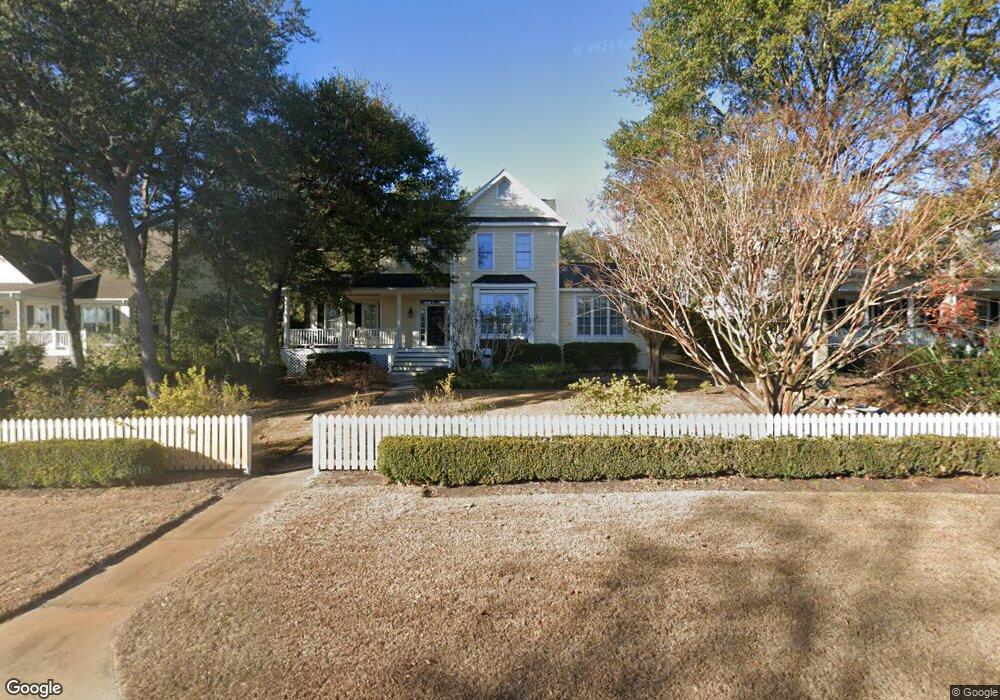
6094 Sullivan Ridge Rd Southport, NC 28461
Estimated Value: $621,496 - $739,000
3
Beds
3
Baths
2,282
Sq Ft
$305/Sq Ft
Est. Value
About This Home
This home is located at 6094 Sullivan Ridge Rd, Southport, NC 28461 and is currently estimated at $696,874, approximately $305 per square foot. 6094 Sullivan Ridge Rd is a home located in Brunswick County with nearby schools including Southport Elementary School, South Brunswick Middle School, and South Brunswick High School.
Ownership History
Date
Name
Owned For
Owner Type
Purchase Details
Closed on
Oct 2, 2025
Sold by
Horan Lawrence
Bought by
Lawrence Horan Revocable Trust and Horan
Current Estimated Value
Purchase Details
Closed on
Aug 1, 2002
Bought by
Horan Lawrence Et Maureen D
Create a Home Valuation Report for This Property
The Home Valuation Report is an in-depth analysis detailing your home's value as well as a comparison with similar homes in the area
Home Values in the Area
Average Home Value in this Area
Purchase History
| Date | Buyer | Sale Price | Title Company |
|---|---|---|---|
| Lawrence Horan Revocable Trust | -- | None Listed On Document | |
| Horan Lawrence Et Maureen D | $295,500 | -- |
Source: Public Records
Tax History Compared to Growth
Tax History
| Year | Tax Paid | Tax Assessment Tax Assessment Total Assessment is a certain percentage of the fair market value that is determined by local assessors to be the total taxable value of land and additions on the property. | Land | Improvement |
|---|---|---|---|---|
| 2025 | $3,856 | $499,470 | $100,000 | $399,470 |
| 2024 | $3,856 | $499,470 | $100,000 | $399,470 |
| 2023 | $3,724 | $499,470 | $100,000 | $399,470 |
| 2022 | $3,724 | $361,020 | $60,000 | $301,020 |
| 2021 | $3,238 | $361,020 | $60,000 | $301,020 |
| 2020 | $3,238 | $361,020 | $60,000 | $301,020 |
| 2019 | $3,238 | $60,810 | $60,000 | $810 |
| 2018 | $2,973 | $66,040 | $65,000 | $1,040 |
| 2017 | $2,948 | $66,040 | $65,000 | $1,040 |
| 2016 | $2,733 | $66,040 | $65,000 | $1,040 |
| 2015 | $2,733 | $328,730 | $65,000 | $263,730 |
| 2014 | $2,659 | $337,696 | $126,500 | $211,196 |
Source: Public Records
Map
Nearby Homes
- 5122 Prices Creek Dr
- 5138 Fernwood Dr
- 1.12 Ac Jabbertown Rd
- 5122 Fernwood Dr
- 5147 Fernwood Dr
- 136 Park Ave
- 305 Fire Fly SE
- 5975 Gray Squirrel Path
- 301 Fire Fly Ln
- 202 Fire Fly Ln
- 411 Fire Fly Ln
- 308 Fire Fly Ln
- 5988 Gray Squirrel Path
- 492 Jabbertown Rd
- 2035 Oakton Dr Unit 9
- 131 Stuart Ave Unit 42
- 131 Stuart Ave
- 2079 Rosin Dr
- 2079 Rosin Dr Unit 17
- 1014 Softwind Way
- 6092 Sullivan Ridge Rd
- 6096 Sullivan Ridge Rd
- 6064 Sullivans Ridge
- 6068 Sullivans Ridge
- L-100 Sullivans Ridge
- 6090 Sullivans Ridge
- 0 Sullivans Ridge Unit 20634486
- 0 Sullivans Ridge Unit 20651979
- 6098 Sullivans Ridge
- 6093 Sullivan Ridge Rd
- 6095 Sullivan Ridge Rd
- 6060 Sullivan Ridge Rd
- 5110 Hollow Tree Dr
- 6088 Sullivan Ridge Rd
- 6099 Sullivans Ridge
- 6062 Sullivan Ridge Rd
- 100 Sullivan Ridge Rd
- 0 Sullivan Ridge Rd
- 6090 Sullivan Ridge Rd
- 6070 Sullivan Ridge Rd