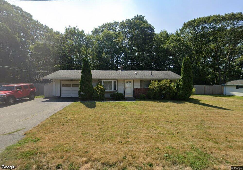
61 Bernard Rd Brockton, MA 02302
Montello NeighborhoodEstimated Value: $416,000 - $471,000
3
Beds
1
Bath
864
Sq Ft
$512/Sq Ft
Est. Value
About This Home
This home is located at 61 Bernard Rd, Brockton, MA 02302 and is currently estimated at $442,066, approximately $511 per square foot. 61 Bernard Rd is a home located in Plymouth County with nearby schools including Brookfield Elementary School, Mary E. Baker Elementary School, and Downey Elementary School.
Ownership History
Date
Name
Owned For
Owner Type
Purchase Details
Closed on
Aug 20, 2004
Sold by
Carnes Jason
Bought by
Miller Thomas E and Nguyen Jennifer
Current Estimated Value
Home Financials for this Owner
Home Financials are based on the most recent Mortgage that was taken out on this home.
Original Mortgage
$240,230
Interest Rate
6.03%
Mortgage Type
Purchase Money Mortgage
Purchase Details
Closed on
Sep 28, 2001
Sold by
Brouthers Cheryl A
Bought by
Carnes Jason
Home Financials for this Owner
Home Financials are based on the most recent Mortgage that was taken out on this home.
Original Mortgage
$129,600
Interest Rate
6.91%
Mortgage Type
Purchase Money Mortgage
Purchase Details
Closed on
Mar 24, 1998
Sold by
Foley Brian M and Carol Foley J
Bought by
Brouthers Dennis H and Brouthers Cheryl A
Create a Home Valuation Report for This Property
The Home Valuation Report is an in-depth analysis detailing your home's value as well as a comparison with similar homes in the area
Home Values in the Area
Average Home Value in this Area
Purchase History
| Date | Buyer | Sale Price | Title Company |
|---|---|---|---|
| Miller Thomas E | $244,000 | -- | |
| Carnes Jason | $162,000 | -- | |
| Brouthers Dennis H | $97,700 | -- |
Source: Public Records
Mortgage History
| Date | Status | Borrower | Loan Amount |
|---|---|---|---|
| Open | Brouthers Dennis H | $217,949 | |
| Closed | Brouthers Dennis H | $240,230 | |
| Previous Owner | Brouthers Dennis H | $129,600 |
Source: Public Records
Tax History
| Year | Tax Paid | Tax Assessment Tax Assessment Total Assessment is a certain percentage of the fair market value that is determined by local assessors to be the total taxable value of land and additions on the property. | Land | Improvement |
|---|---|---|---|---|
| 2025 | $4,413 | $364,400 | $159,700 | $204,700 |
| 2024 | $3,994 | $332,300 | $159,700 | $172,600 |
| 2023 | $4,299 | $331,200 | $110,000 | $221,200 |
| 2022 | $4,095 | $293,100 | $100,000 | $193,100 |
| 2021 | $3,911 | $269,700 | $92,700 | $177,000 |
| 2020 | $3,703 | $244,400 | $81,400 | $163,000 |
| 2019 | $3,459 | $222,600 | $77,600 | $145,000 |
| 2018 | $3,498 | $217,800 | $77,600 | $140,200 |
| 2017 | $2,887 | $179,300 | $77,600 | $101,700 |
| 2016 | $2,767 | $159,400 | $74,000 | $85,400 |
| 2015 | $2,801 | $154,300 | $74,000 | $80,300 |
| 2014 | $2,462 | $135,800 | $74,000 | $61,800 |
Source: Public Records
Map
Nearby Homes
- 53 Bernard Rd
- 69 Bernard Rd
- 244 Hovendon Ave
- 250 Hovendon Ave
- 5 Bernard Cir
- 68 Bernard Rd
- 236 Hovendon Ave
- 45 Bernard Rd
- 77 Bernard Rd
- 258 Hovendon Ave
- 76 Bernard Rd
- 6 Bernard Cir
- 230 Hovendon Ave
- 11 Bernard Cir
- 264 Hovendon Ave
- 37 Bernard Rd
- 27 Bernard Cir
- 40 Bernard Rd
- 96 Bernard Rd
- 224 Hovendon Ave
Your Personal Tour Guide
Ask me questions while you tour the home.