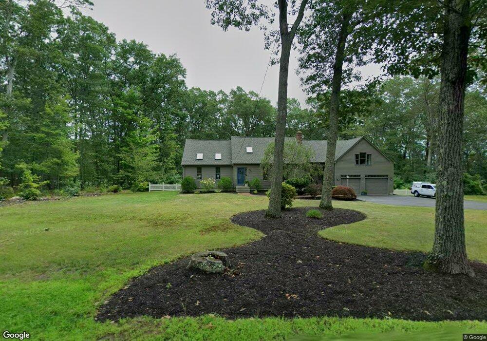
61 Fales Rd North Attleboro, MA 02760
North Attleboro NeighborhoodEstimated Value: $730,000 - $773,000
3
Beds
2
Baths
2,284
Sq Ft
$333/Sq Ft
Est. Value
About This Home
This home is located at 61 Fales Rd, North Attleboro, MA 02760 and is currently estimated at $759,747, approximately $332 per square foot. 61 Fales Rd is a home located in Bristol County with nearby schools including North Attleboro High School and Mercymount Country Day School.
Ownership History
Date
Name
Owned For
Owner Type
Purchase Details
Closed on
Mar 8, 2023
Sold by
Burns Steven W and Burns Lisa H
Bought by
Arlene A Hickey Irt
Current Estimated Value
Purchase Details
Closed on
Feb 28, 2023
Sold by
Arlene A Hickey Irt
Bought by
Burns Steven W and Burns Lisa H
Create a Home Valuation Report for This Property
The Home Valuation Report is an in-depth analysis detailing your home's value as well as a comparison with similar homes in the area
Home Values in the Area
Average Home Value in this Area
Purchase History
| Date | Buyer | Sale Price | Title Company |
|---|---|---|---|
| Arlene A Hickey Irt | -- | None Available | |
| Arlene A Hickey Irt | -- | None Available | |
| Burns Steven W | -- | None Available | |
| Burns Steven W | -- | None Available |
Source: Public Records
Tax History Compared to Growth
Tax History
| Year | Tax Paid | Tax Assessment Tax Assessment Total Assessment is a certain percentage of the fair market value that is determined by local assessors to be the total taxable value of land and additions on the property. | Land | Improvement |
|---|---|---|---|---|
| 2025 | $8,159 | $692,000 | $153,900 | $538,100 |
| 2024 | $7,706 | $667,800 | $151,900 | $515,900 |
| 2023 | $7,758 | $606,600 | $151,900 | $454,700 |
| 2022 | $7,103 | $509,900 | $151,900 | $358,000 |
| 2021 | $6,890 | $482,800 | $151,900 | $330,900 |
| 2020 | $6,690 | $466,200 | $151,900 | $314,300 |
| 2019 | $6,452 | $453,100 | $138,800 | $314,300 |
| 2018 | $5,715 | $428,400 | $138,800 | $289,600 |
| 2017 | $5,264 | $398,200 | $138,800 | $259,400 |
| 2016 | $5,191 | $392,700 | $153,600 | $239,100 |
| 2015 | $4,807 | $365,800 | $161,000 | $204,800 |
| 2014 | $4,618 | $348,800 | $149,300 | $199,500 |
Source: Public Records
Map
Nearby Homes
- 41 Stone Ridge Rd
- 34 Stone Ridge Rd
- 740 Allen Ave
- 12 Intervale Dr
- 30 Sperry Ln Unit Lot 15
- 0 Anawan Rd
- 160 Crescent Ave
- 105 Newell Dr
- 46 Westside Ave
- 25 Gregory Way
- 49 Hoppin Hill Ave
- 22 Gilbert Ct
- 44 Powder Horn Way
- 16 Johnson St
- 50 Metcalf Rd
- 16 Wollen Dr
- 80 Broadway Unit 9
- 12 Roosevelt Ave
- 12 Morgan Way Unit 1
- 334 S Washington St