Estimated Value: $260,000 - $314,000
3
Beds
3
Baths
1,764
Sq Ft
$162/Sq Ft
Est. Value
About This Home
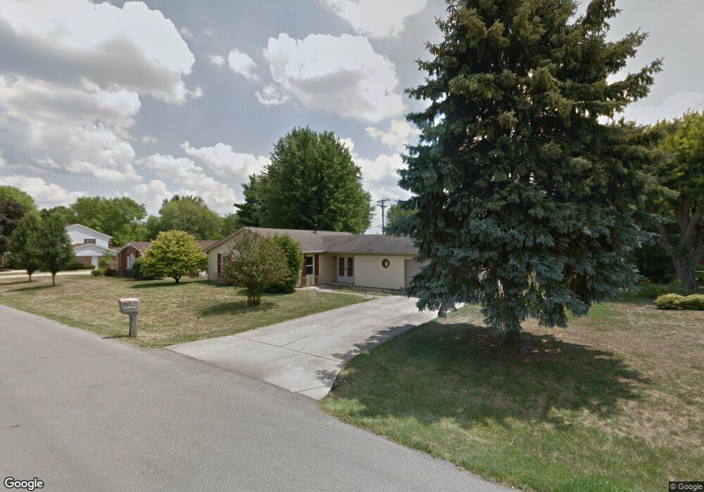
This home is located at 61 Hardacre Dr, Xenia, OH 45385 and is currently estimated at $285,756, approximately $161 per square foot. 61 Hardacre Dr is a home located in Greene County with nearby schools including Xenia High School, Summit Academy Community School for Alternative Learners - Xenia, and Legacy Christian Academy.
Ownership History
Date
Name
Owned For
Owner Type
Purchase Details
Closed on
Dec 11, 2012
Sold by
Fannie Mae
Bought by
Russell Natalie E
Current Estimated Value
Home Financials for this Owner
Home Financials are based on the most recent Mortgage that was taken out on this home.
Original Mortgage
$104,298
Interest Rate
3.5%
Mortgage Type
FHA
Purchase Details
Closed on
May 7, 2012
Sold by
Zehring David M
Bought by
Federal National Mortgage Association
Purchase Details
Closed on
Feb 28, 2007
Sold by
Stavick Robert E and Stavick Shirley W
Bought by
Zehring David M and Zehring Christine A
Home Financials for this Owner
Home Financials are based on the most recent Mortgage that was taken out on this home.
Original Mortgage
$116,000
Interest Rate
6.28%
Mortgage Type
Unknown
Purchase Details
Closed on
Aug 7, 2001
Sold by
Stavick Robert E and Stavick Shirley W
Bought by
Stavick Robert E and Stavick Shirley W
Create a Home Valuation Report for This Property
The Home Valuation Report is an in-depth analysis detailing your home's value as well as a comparison with similar homes in the area
Home Values in the Area
Average Home Value in this Area
Purchase History
| Date | Buyer | Sale Price | Title Company |
|---|---|---|---|
| Russell Natalie E | $107,900 | None Available | |
| Federal National Mortgage Association | $80,000 | None Available | |
| Zehring David M | $145,000 | Midwest Title Company | |
| Stavick Robert E | -- | -- |
Source: Public Records
Mortgage History
| Date | Status | Borrower | Loan Amount |
|---|---|---|---|
| Previous Owner | Russell Natalie E | $104,298 | |
| Previous Owner | Zehring David M | $116,000 |
Source: Public Records
Tax History
| Year | Tax Paid | Tax Assessment Tax Assessment Total Assessment is a certain percentage of the fair market value that is determined by local assessors to be the total taxable value of land and additions on the property. | Land | Improvement |
|---|---|---|---|---|
| 2025 | $3,395 | $69,270 | $13,880 | $55,390 |
| 2024 | $3,395 | $69,270 | $13,880 | $55,390 |
| 2023 | $3,367 | $69,270 | $13,880 | $55,390 |
| 2022 | $2,797 | $52,150 | $11,570 | $40,580 |
| 2021 | $2,832 | $52,150 | $11,570 | $40,580 |
| 2020 | $2,722 | $52,150 | $11,570 | $40,580 |
| 2019 | $2,377 | $42,760 | $10,260 | $32,500 |
| 2018 | $2,386 | $42,760 | $10,260 | $32,500 |
| 2017 | $2,278 | $42,760 | $10,260 | $32,500 |
| 2016 | $2,279 | $40,160 | $10,260 | $29,900 |
| 2015 | $2,285 | $40,160 | $10,260 | $29,900 |
| 2014 | $2,194 | $40,160 | $10,260 | $29,900 |
Source: Public Records
Map
Nearby Homes
- 1038 Lark Ln
- 1809 Palmer Ct
- 1556 N Regency Dr
- 1044 Whitestone Rd
- 167 Beverly Place
- 1785 Tahoe Dr
- 1461 Pavey Place
- 289 Hollywood Blvd
- 2096 Sierra Trail
- 955 Oak Dale Dr
- 2255 Monterey Dr
- 634 Martin Dr
- 453 Hollywood Blvd
- 461 Hollywood Blvd
- 1359 Eagles Way
- 179 Omalee Dr
- 1785 Palmer Ct
- 1796 Palmer Ct
- 1790 Palmer Ct
- 1808 Palmer Ct
Your Personal Tour Guide
Ask me questions while you tour the home.